10:30pm Update: Serious Tornado Risk Wednesday Afternoon and Evening; Increasing Flood Risk
Note: As of 8:15am Wednesday, this forecast has been updated. Please go here for the latest.
As of 10:30pm Tuesday, it appears the strong tornado forecast (hatching) may have to be brought south into Kay and Osage counties of Oklahoma and west to I-35 in south central Kansas.
I will have an update in the mid- to late morning Wednesday.
1:30pm: It is important that people in the threatened areas (below) pay close attention to the weather Wednesday afternoon and evening. This includes school officials.
Please note the Dallas-Ft Worth Metroplex is included in the "significant" tornado risk area. There is also a risk of damaging thunderstorm winds throughout these areas.
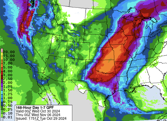
In addition.... a heads up for flooding:
Above is the 7-day rainfall forecast. The amber area on the Kansas-Oklahoma border is a forecast of 7 inches of rain! The orange area from Missouri to the Red River is 5-7 inches. While much of this area is in drought, this is enough rain that at least localized flooding will occur. The NWS's 7-day National Flood Outlook calls for no flooding. I believe this is another very poor forecast from this organization.
Of course, I will update these forecasts tomorrow.
--- original text ---
Of course, I will update the situation.


Comments
Post a Comment