5pm EDT [Updated] Dangerous Hurricane Milton Moving Toward Florida's Gulf Coast
Satellite image at 2:25pm CDT shows intensifying Hurricane Milton developing an eye. The storm has maximum winds of 80 mph and the central pressure has dropped to 988 millibars.
 |
| 3pm CDT |
My forecast for the point of landfall for the eye has barely changed since yesterday.
I am forecasting the eye to make landfall between the two arrows. However, in addition to the danger of winds in the eyewall, there will be a life-threatening storm surge! For example, if the eye passes just north of Tampa Bay and it reaches at least Cat 2 intensity, there will be places that experience a storm surge of more than 9 feet above sea level. By far, the worst storm surge effects will be near and south of the eye. The intensity forecast is rather difficult. The models are all over the map. My best forecast at this point is that the storm will be Cat 2 or 3 at landfall. Cat 4 is certainly possible. That is sufficient to cause serious damage. The fact the storm will strike the coast at or near a 90° angle will worsen both the wind and surge damage.
If you live 9 or fewer feet above sea level, you may wish to consider leaving sooner rather than later. Jacksonville, Talahasseee, Destin, and Mobile are all good locations. I would not evacuate to Florida's east coast south of JAX.
More Florida information, here.
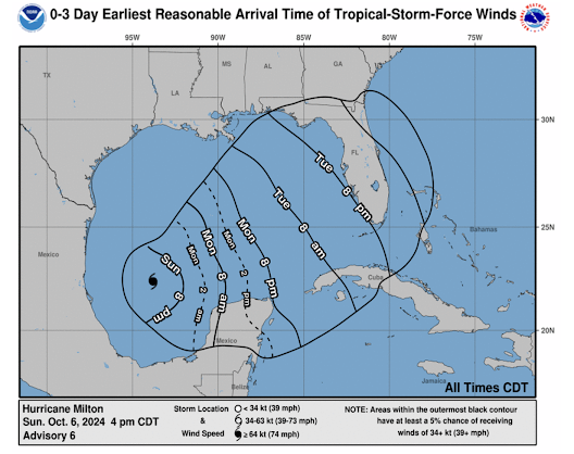
Earliest time of arrival for 40 mph or stronger winds.
Preparation Suggestions:
- Make sure you have adequate food and water for at least a week after the storm. Fill your generator if you have one, with fuel.
- Fuel your car. Same with your chainsaw if you have one. Trees will fall.
- Refill prescriptions.
- Make sure you know the sea level elevation of your home. If you don't know, use the "compass" app on your iPhone. Put it on the floor of a room of your home and it will tell you how high your home is. This will be important when storm surge warnings are issued.
- Get plenty of cash from the ATM. Cash registers, fuel pumps, etc., do not work with power after the storm.
- Make certain elderly and infirm friends and relatives are cared for.
From insurance expert Andrew Sieffert:
The Tampa Bay area, with its extensive waterfront property and a population that has ballooned from 450,000 in 1946 to 4.1 million today, faces significant risks from Milton’s approach. A major hurricane could lead to catastrophic flooding, especially if the storm's track funnels water into the bay. This scenario would submerge key areas like Tampa Airport and Downtown Tampa. The storm could also bring strong winds across central Florida, impacting cities along the I-4 corridor. With Milton poised to be the fifth landfalling hurricane of the 2024 season, this could further strain the insurance industry, which is already dealing with damages from previous storms this season. Now is the time for the industry and residents to prepare for potentially devastating impacts.
Additional Information from NHC at 5pm EDT:
Update: The central pressure was 983 mb and wind speed was 85 mph.
They are forecasting a wind speed of 145 mph (Cat 4) west of Florida. Wind speed at 1pm Wednesday is forecast at 120 mph. Near and south of the eye, there will be a severe storm surge. If it goes over or just north of Tampa Bay, we may have another catastrophe on our hands. Their path forecast is below. It is similar to mine.


Comments
Post a Comment