1:40pm EDT Update on Now Cat 5 Hurricane Milton
There is later information. Please go here to view it.
-- 1:40pm Posting --
Based on new data from the Hurricane Hunters, it appears winds are 175 mph and it looks like the central pressure has dropped to about 912 millibars.
The Hurricane Center says its winds are 175 mph. They are at least that. The "vortex message," a route message from the Hurricane Hunters, has winds even stronger.
You will find information on current evacuation orders here.
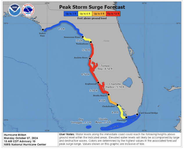
Note: the hurricane may weaken due to its interaction with the Yucatan Penninsula on its way east then northeast. It is not expected to be as strong as it is when it strikes Florida. However, like Katrina, the storm surge Milton is now creating will be devastating.
-- 12:55pm posting --
I agree with Dr. Cowan's interpretation of the newest Hurricane Hunter data.
-Wind gusts are to 175 mph, pressure 925 millibars-
11:46am EDT satellite image. The pressure has dropped an amazing 22 mb in 4 hours down to 933 millibars. --- original posting from 11:10am ---
NHC has tweaked its forecast to show the hurricane's most likely path right over Tampa Bay.
Color codes:- Red = hurricane warning.
- Blue = tropical storm warning.
- Pink = hurricane watch.
- Yellow = tropical storm watch.
At landfall, the forecast wind speed -- of a hurricane much larger in size -- of 125 mph will bring with it a life-threatening storm surge.
In addition to the storm surge, Milton will bring tornadoes -- primarily along and south of I-4 -- to the Florida Peninsula and flooding rains. Rainfall amounts may exceed, in places, the amounts shown on the map below.
And, no, the movement of this storm is not caused by weather modification. It is a result of conditions in the upper atmosphere. More on weather modification here.


Comments
Post a Comment