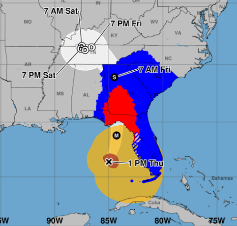
2:25pm EDT Forecast for Helene...
.... has not changed since last night.
Current winds are 110 120 mph (Hurricane Hunters just reported) and the pressure in the eye is 959 mb. Winds are expected to be about 130 mph at landfall with even stronger gusts. When it gets to Atlanta, the winds are forecast to be 65 mph with stronger gusts. The hurricane warning (red) extends far inland with a tropical storm warning (blue) all the way into North Carolina and Tennessee.
 |
| The National Hurricane Center uses Central time on this graphic. |
The amber is 39 mph or stronger winds and the brown is the current location of hurricane force winds -- which may grow in size. Power outages will be widespread and will last for days in many cases.
Tornadoes are possible anywhere in this region today and tonight.
The flood forecast is unchanged from yesterday, please see the posting below this one for complete info on the flooding threat.
Latest satellite image (2:21pm) is below.


Comments
Post a Comment