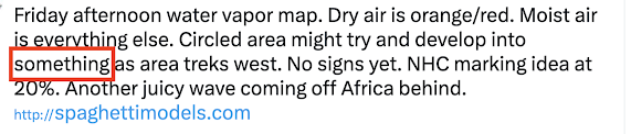
Posts

Showing posts from July, 2024

Whitman Unwarned Tornado, Part Two; Livonia Fatal Unwarned Tornado Reports

Image
Last week, I reported on the National Weather Service’s terrible miss of an obviously strong tornado that did damage in the Whitman, Nebraska area.  In this report, I am going to provide additional information pertaining to that event and tell the story of a fatal NWS tornado warning miss near Detroit last month.      Whitman, Nebraska, Tornado Warning Miss You can read my initial report  here . Since then, I have learned the issue was neither the nationwide outage of some National Weather Service (NWS) data that was in progress nor was there a problem with any system at the North Platte NWS Office. There appears to be an issue regarding the ability of some NWS meteorologists to properly evaluate radar.  As we have reported the last few years, that is not a unique issue.      Unfortunately, the National Weather Service, as usual, has gone into defensive mode and has not issued a statement about this fiasco even though some of us expected one. The NWS simply will not provide objective i

10:30 Update on Hurricane Beryl

Image
Beryl is now attacking Jamaica, which is the large island south of Cuba. Kingston is on the south side of the island and will be suffering a great deal of damage. Sustained winds are around 140-145 mph and there will be major storm surge.  I have modified the forecast from the National Hurricane Center, below. Here is a color code: Red outlines for Jamaica, Cayman Islands and east Yucatan are hurricane warnings.  The yellow on the north side of Yucatan and Belize are tropical storm warnings.  Brown is the radius of hurricane force winds, greater than 75 mph. Amber is winds 40 to 74 mph.  White is the "confidence cone" which is where the center  of Beryl is forecast to be. It is important to remember that the effects of the storm will be larger than the cone.  Orange lines are my extension of the confidence cone. I believe that the Texas coast is now in play. The storm would arrive Sunday or Sunday night. Intensity is too soon to say.  I will update this evening. 

Validation of July 1 Tornado Mini-Forecast

Image
Whenever possible, I like to narrow down tornado danger areas. I issued one of my mini-forecasts Monday afternoon on Twitter/X. See below.  At 4:29pm I forecast tornadoes within the blue outline from 5 until 6:30pm.   What actually happened? The red dots are the locations of tornadoes. The first was at 5:51pm and within the forecast area. All of the rest of the tornadoes were in the mini-forecast except for the easternmost which was just past the forecast. However, the more eastern two tornadoes occurred after 6:30. I have a tendency to end these forecasts too soon, so it is something I need to keep in mind.  How would I grade this forecast? B. 

11pm Update on Cat 4 Beryl

Image
We have hurricane warnings  for Jamaica (major hurricane intensity) and the Cayman Islands. A hurricane watch has been issued for the Yucatan.  Unfortunately, it now looks like the US is now in play, so more detailed coverage of Beryl will begin Wednesday.

Wichita - Bird Fleeing Severe Thunderstorm

Image
The photo depicts a "shelf cloud" from above the building to the tree which is the leading edge of rain-cooled air accompanied by gusts up to 70 mph in various parts of Wichita. There's a report of trees toppled in the northwest part of the city. At upper right, you see a bird fleeing the storm.  If you like this photo, see my collection (available for licensing) here .  And, I thought you might enjoy this photo taken shortly before sunset. 

Tornado Forecasts - Updated at 4:55pm

Image
Tornadoes, 2" hail and 75 mph winds are forecast to occur.  Please note that, in addition to tornadoes, the forecast is for 2" hail and wind gusts to 70 mph which have the potential to cause tree damage and power outages.  -- original, and still valid, posting --- The brown area has a significant risk of tornadoes. Please keep up on the weather later today. I will provide an update this afternoon. 

Latest on Cat 5 Hurricane Beryl

Image
Here is the current forecast pertaining to Cat 5 Hurricane Beryl with 165 mph winds. A hurricane warning is in effect for Jamaica and a hurricane watch is in effect for the Cayman Islands.  Yes, the forecast has been nudged a bit to the north in the Gulf of Mexico. But, it should be pointed out that S  means "tropical storm" while H  means hurricane and M  means "major" (Cat 3-5) hurricane. 

Hurricane Beryl - Earliest Cat 5 in Atlantic History!

Image
Satellite Image at 11:20pm Latest Forecast A hurricane warning   is now in effect for Jamaica. Evacuation of tourists is a good idea, if possible. Cayman Islands should monitor closely. 

Tornado Watch - Nebraska - 4pm Update

Image
A tornado watch has been issued for much of southern Nebraska.  Below is the radar from 3:59pm. The storms The thunderstorms at lower left in the tornado watch are continuing to intensify. Keep an eye on the weather until 10pm if you are in the tornado watch area. 

Beryl Update - 11:15am Monday

Image
Here is an update on strong Cat 4 Hurricane Beryl.  Please note there is now a hurricane watch in effect for Jamaica. At this point there is no  watch for the Cayman Islands but that area will have to be monitored. 

The Sorry Invisibility of Weather Science

Image
Does anyone else see anything missing in the captioning of the Twisters  trailer? In  Warnings ,  I wrote that weather science is the "Rodney Dangerfield of the sciences -- we get no respect." This is screen capture of a closed caption from the Twisters  trailer certainly an example.  A movie about weather and tornadoes and there is no mention of the National Weather Service or NOAA -- even though the movie's technical advisor was an employee of a NOAA lab! I don't blame him, I blame our science and the distaste many meteorologists have for engaging the public. And, while I won't name names, some of the people who are anti-public relations are the same people who complain that weather science is underfunded.  Weather science has cut the death rate (deaths per million population) by 95%. It is estimated the warnings for Hurricane Katrina saved more than 30,000 lives! Those are Nobel-worth accomplishments but hardly anyone knows about them. Our science needs to do a

Exactly Right: "How to Be a Global Warming Activist"

Image
Enough said!!