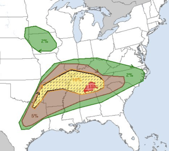
Overnight Tornado Forecast Update 8:50pm CDT
After another eight hours, this ends my coverage for the night.
Below are forecasts for the remainder of the night, please look them over.
Tornado Forecast for the Rest of the Night
- In the red, there is a high risk of tornadoes, some strong, between now and 1am
- The yellow hatched area is where there is an enhanced risk of strong tornadoes the rest of the night.
- The brown area has a significant risk of tornadoes until 7am Thursday
New Tornado Watch Until 3am CDT Thursday
This is one of the most extraordinary radar images I've ever seen. This is the Dopper wind velocity data for the east half of Tennessee and far northern Alabama. I've the circled the rotation for each of the tornado warnings (red polygons). 809p CDT
Severe thunderstorm and tornado risk increasing as more storms from from around Dallas to points northeast. Please monitor the area in the red outlined area.
This is the radar and tornado watches (amber) currently in effect (6:09pm).
Thunderstorms are starting to develop in north central Texas. The dangerous thunderstorm with the strong tornado continues south of Nashville. Data: 6:12pm.
Tornado watch (red outline) for eastern Tennessee, northern Alabama (including Huntsville) and northern Georgia.
New tornado watch, including the DFW Metroplex, has been issued.
Damaging Wind Forecast
This will be a major problem today.
Where you see hatching, the forecast is for wind gusts to 75 mph or stronger -- in the rest of the area, the forecast is for gusts of 60 mph or stronger. - The purple area has a high risk.
- The red area has an enhanced risk.
- The yellow area has a signifiant area.
Giant Hail Forecast
The hatched area is where hailstones 2" in diameter or larger are forecast to fall. In the rest of the area, hail 1" or larger is forecast.
- The purple area has a high risk.
- The red area has an enhanced risk.
- The yellow area has a signifiant area.
I will provide at least one forecast update later today. You are encouraged to follow me on Twitter for real-time updates @usweatherexpert.


Comments
Post a Comment