Great Plains: Dangerous Storms Monday!
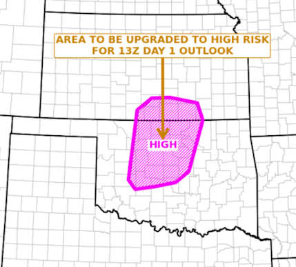
As of 7:30am Monday, the NWS has announced they will be upgrading their forecast to "high risk" -- which is the highest on their 5-point scale. The last high risk in the region was five years ago in 2019. This level of threat is rare..
---------
For the first time since I created my 4 point risk scale four years ago, I am forecasting my highest category of tornado risk, which is "extreme" (purple), in a forecast for the next day. Because the gradient seems so tight, I am skipping the "high" risk category. Red outlines the enhanced risk and orange outlines the significant risk. Strong tornadoes are likely, especially in the purple outlined area.
Damaging Wind Forecast Valid 6pm Monday Until 6am Tuesday
- Hatching = wind gusts of 75 mph or stronger. Otherwise, the forecast is for wind gusts of 60 mph or stronger.
- Red = enhanced probability of winds stronger than 60 mph.
- Yellow = significant risk of winds greater than 60 mph.
Large Hail Forecast 2pm Until 6am Tuesday
Color code:
- Hatching is where hail larger than 2" is forecast.
- Purple = high risk of giant hail 2 to 4" in diameter.
- Red = enhanced risk of hail 2 to 3.5" in diameter.
- Yellow (unhatched) = significant risk of hail 1" in diameter or larger.
This is a situation where I recommend calling your friends and relatives in the highest risk area to make sure they are going to be following the weather tomorrow. I invite you to pass along this blog's URL ( www.mikesmithenterprisesblog.com ) and my Twitter handle where I post real-time updates, which is @usweatherexpert.
Needless to say, I recommend the following:
- At least three independent ways of receiving warnings. Make sure your phone and laptop are fully charged, but take them off of the charger the first time you hear thunder (in order to prevent power-surge damage).
- I sleep better at night with StormWarn. It calls you 24/hr. day but, unlike other systems, it calls only if you are in the path of a tornado or wind gust of 80 mph or stronger. Me? I don't want calls or a weather radio going off at 3am for 1" hail.
- Power outages are likely in the areas where 75+ mph winds are forecast. Prepare accordingly.
- Make sure your tornado sheltering area is ready to go: bottles of water, diapers, shoes (if the worst happens, you don't want to be walking on metal shards and broken glass) and -- if you have them and wish to do so -- hard hats like a football helmet, baseball batter's helmet, et cetera.
- Put your lawn furniture and other items that can blow around indoors.
Of course, I will update this forecast Monday morning.
The tornadoes I am forecasting will be at least this strong!
Remember:
------------------------------------------
Discussion for Meteorologists
This meteorological situation looks a lot like May 8, 2003, except about 100 miles to the southwest.
I ran the USAF Miller 12-point checklist for tornado forecasts and, while #8 can't be determined with today's models, all of the others were "strong" on his 3-point scale.
12:05am addition: NADOCAST more or less confirms this forecast but also takes the extreme risk toward Hobart, OK. That is a possible outcome but none of the other guidance tools up the risk probabilities in southwest Oklahoma. CSU's tornado forecast from 00Z is identical to my extreme risk, unfortunately. The STL U analogs are:
- April 26, 1991
- May 8, 2003
Take a look at the 00Z 300mb chart. The difluence over south central Kansas is among the strongest I've ever seen.


Comments
Post a Comment