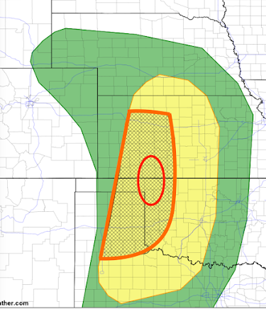
[Updated] Thursday and Friday Tornado and Severe Thunderstorm Risk
Thursday and Thursday Night Forecast
The yellow area has a significant risk of tornadoes and severe thunderstorms (large hail and damaging thunderstorm-generated winds). The orange, hatched area is where there is an enhanced risk giant hail and tornadoes are more likely. The red oval is where I believe there is a higher risk of tornadoes, especially Thursday evening. Update:
The NWS has updated their forecast for Thursday and it is below.
Their red area is very similar to my orange area. However, they pull their higher risk area to include Hutchinson and Pratt and it is close to Wichita. Where you see red + hatching in their forecast there is an enhanced risk of strong tornadoes and hail 2-3" in diameter. Elsewhere, where you see the hatching, there is a risk of tornadoes but the primary risk is hail ≥ 2 inches.
With the potential for strong tornadoes, it is important to monitor the weather Thursday (and Friday, see below). Of course, I will update these forecasts tomorrow.
Friday and Friday Night
If everything comes together, Friday has the potential to be a major tornado and severe thunderstorm day. Here is the color code:- Yellow = significant risk of tornadoes and severe thunderstorms.
- Orange = enhanced risk.
- Red rectangle = high risk.
Of course, these are preliminary forecasts and the risk areas may have to be adjusted somewhat. However, late April is getting into the peak of "tornado season" so it is time to make sure you have fresh batteries for your weather radio, WEA alerts are activated on your smartphone and your tornado sheltering area is ready to go.
If you live in a mobile home without a neighborhood shelter, please consult this map for community tornado shelters.


Comments
Post a Comment