Wednesday: Updated Tornado and Heavy Snow Forecasts
The tornado forecast has been updated. Go here.
The snow forecast has been updated. Go here.
--- original post ---
Colorado and Wyoming -- Updated 2:40pm MDT
Here is the color code:- Pink = winter storm warning.
- Purple = winter weather advisory.
- Dark blue = winter storm watch.
- Magenta = very high wildfire danger, go here for more information.
The winter storm warning includes Denver and parts of I-70 and I-25. In downtown Denver, 6-12" is predicted to fall, although there are some models that are showing more. The most significant snow will begin tomorrow night. This is forecast to be the biggest snowstorm in at least three years.
Tornado Threat - Updated 3:35pm CDT
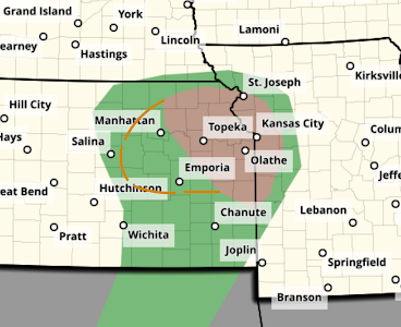
The brown area, which also includes Tuttle Creek, Lawrence and Ft. Scott has a significant risk of tornadoes Wednesday afternoon and night. I have also added a dashed brown line. It outlines an area where -- if any strong thunderstorms develop -- tornadoes are also possible.
In addition, there is a risk of giant hail (yellow, hatched) larger than two inches.
The yellow area has a significant risk of hail 1" or larger. I will update this forecast tomorrow morning. In the meantime, make sure your tornado safety area is ready to go for 2024.


Comments
Post a Comment