California: Forecast of Dangerous Flash Flooding, Wind, and Snow [Update #2]
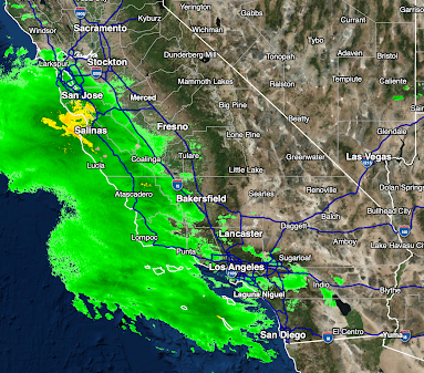
This is a complex, powerful storm. I've marked the center of low pressure of the coast as the storm moves east. The leading edge of the rain is just reaching the coast between Salinas and Point Conception.
[Added 5:20pm radar image]
Rain has moved onto the coast from Marin County, south to almost San Diego. I'm braking the storm down by hazard types.
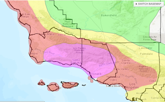
Flash Flood Forecast
This is the forecast for California from 4am Sunday to 4am Monday. Note that San Francisco and the south Bay Area is in the "high" risk area Sunday.
There is also a slight risk of a tornado from Carmel to Point Conception Sunday afternoon.
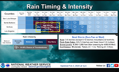
Forecast rainfall from 4pm this afternoon to 4am Tuesday.
Peak amounts are right at eleven (11) inches. Updated at 2pm for Los Angeles:
Total amount from this afternoon to Saturday morning. Peak amount is 13 inches.
Snow and Blizzard ConditionsThe maximum amount will be around 40 inches in the next three days with the heaviest amounts and blizzard conditions possible south of I-80. Snow in the Southland:
Peak Winds
Below are the peak wind gusts expected between now and mid-morning Tuesday.


I love great weather events, however, living in Southern California doesn't provide much to sink our teeth into, so I have to search the country for something good. I love the beautiful Eastern Sierras between Bishop and Reno.There can be some interesting snow events between January and April. I like to try my hand at forecasting so when we do get a strong storm I like to see what happens. There are many times when heavy rain is predicted for Southern California and yet it never happens. I have a theory as to why. When NWS is tracking a strong storm out over the Pacific, they see it as it is, but then when the storm moves over land the storm changes its characteristics. I have to believe storms change due to ground or water. So instead of being upset for not seeing the predicted results, or blaming the weather men I figure the storm changed as it came over land. I think my theory holds water (as it were), but the weather men never factor that in.
ReplyDelete