Updated Freezing Rain and Heavy Rain Forecast
Note: An Updated Forecast is Available HERE
Freezing Rain
The National Weather Service has now issued winter weather advisories, two warnings and a watch. It may be a bit too large but, when it comes to freezing rain and slick roads, caution is usually the better course of action. Here's a color code:
- Deep purple is an ice storm warning; serious condition where power outages are possible.
- Pink is a winter storm warning for significant icing.
- Deep green is a winter storm watch. I don't know why this is still a watch. If I were on the forecast desk I would have a winter storm warning for icing.
- Dark blue is a winter weather advisory, a lesser condition, for icing.
Here is a view of the entire watch/warning/advisory area. The small area of green in Illinois is for flooding and, in Nebraska, for snow.
Here is a forecast of freezing rain amounts; totals to 6am Tuesday.
Color codes:- Yellow is 0.25 to 0.50 inches. Power outages may occur in this areas.
- Deep blue is 0.1 to .25 inches.
- Medium blue is 0.05 to 0.1 inches.
- Light blue is 0.01 to 0.05 inches.
- Turquoise is trace amounts.
I believe amounts may be over-forecast in Kansas and Missouri northwest of Interstate 35. Regardless, roads will be hazardous in most of these areas.
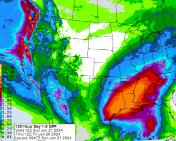
Heavy Rain Forecast
The orange areas are more than five inches. Flooding is likely in the south central states and in the higher elevations of the West. *Please bookmark: http://mikesmithenterprisesblog.com as we'll have a special report pertaining to the New York Times' story about about whether people will be able to get climate data in the future.*


Ummm when?
ReplyDeleteWhat time is it expected to start and end tomorrow?
Delete