Posts

Showing posts from December, 2023

Long Range Snow Outlook

Image
Note: Updated Forecast Here ------ © 2023 Mike Smith Enterprises, LLC Please bookmark:  www.mikesmithenterprisesblog.com If you are in a business where the location and intensity of snow is important, you'll want to take a look at the forecasts below. Looks like 2024 is going to start out meteorologically active.  Snow Forecast through 6pm January 3rd, 2024 Forecast snow for contiguous United States through 6pm Wednesday.  Snow Outlook for January 4 through 12  It appears we will have a very active storm track beginning the middle of this week and continuing through the end of next week. Above, I have provided some general geography to assist you for planning.  I developed the above forecast before the 6-10 day precipitation probability forecast was published by the National Weather Service. It is below. If you compare the eastward bulge through KS and OK, you'll notice it has a similarity to my area of where heavy snow is more likely. That indicates the NWS is viewing this po

Weather Forecast Note to Readers....

Image
© 2023 Mike Smith Enterprises, LLC Please bookmark:  www.mikesmithenterprisesblog.com For those interested, the weather is going to become quite active from coast-to-coast this week and, possibly, into the early part of the week of the 8th. Looks like 2024 is going to come in with a bang! I expect to have comprehensive forecasts posted tomorrow.  In the meantime, here is the forecast rainfall (snow in the Sierra) from 5pm this evening to 10am Tuesday, Pacific Time.   Snowfall Forecast I'll have some general forecasts up later this afternoon so you can plan for the storms later in the week.  In the meantime, please take a look at the essay I have posted below pertaining to the economy and energy in 2024. 

As the Clock Runs Out on 2023....

Image
Copyright 2023, Mike Smith Enterprises, LLC www.mikesmithenterprisesblog.com iStock ....there are reasons for optimism on the climate front and, maybe, the economic front as well. Here are some thoughts on prospects for the New Year.  Economically, new data indicates U.S. productivity (key to rising wages and prosperity) is increasing rapidly (the blue line at far right): absolutely essential for growth. While there were people early in the Biden Administration who were drifting toward the (illusionary) benefits of socialism (example, here ), that boomlet seems to have dampened down a bit -- always a good thing. Of course, we need to get back to a truly free enterprise system rather than the crony capitalism we suffer with these days, regardless of which party is in power. The Actual Climate and the Climate Movement  As reported at the time, the U.S. summer of 2023 was nothing special -- in spite of what Big Climate and their lackeys in government and the MSM wanted you to believe. Th

New Year's Travel Weather

Image
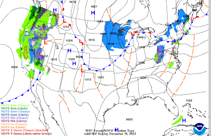
Here is a forecast of travel conditions for the rest of the New Year's Weekend. Note: if you like these forecasts, please booknote: www.mikesmithenterprisesblog.com  6pm Saturday The primary trouble areas tonight will be the western Great Lakes region and the higher passes of the Sierra and Cascades. There will be a few snow showers in the East but they will not be particularly heavy.  6am Sunday The low pressure system will continue east across the Great Lakes bringing some periods of heavy snow (dark blue) will which cause significant travel problems.  6pm Sunday 6am New Year's Day (Monday) Heavy snow will continue in the Great Lakes and Appalachians with poor travel conditions. It would be a good idea to complete any travel in that area before this time. The next weather system moves inland in California. That storm is likely to cause snow in the Rockies and Great Plains as the week progresses. Please check back for later updates. © 2023 Mike Smith Enterprises, LLC Please bo

Now, That's a Flash Flood!

Image
This occurred in Argentina on Christmas. No word as to casualties. Never underestimate to power of flowing water. Sorry for the poor editing.  The location was Poman, in Argentina. 

UPDATED! A "Mad Man" Pop Tarts Bowl

Image
[scroll to bottom for the update] The Twitterverse has spent the last 18 hours talking about last night's Pop Tart's Bowl and how much fun it was.  Our Kansas State Wildcats defeated the North Carolina State Wolfpack 28-19 in a really great game. The Kansas City Star  had an apt headline. Left, the giant Pop Tarts mascot. Right, K-State's QB, and Player of the Game, Avery Johnson.  The Pop Tarts people did an amazing job with their fun "edible mascot" that is being talked about from  Sports Illustrated  to Variety  (the "bible" of show business) to CBS . How did they come up with this idea?  For fans of the television series Mad Men, the Twitterers has been coming up with various Don Draper (the main character ,who is a marketing genius, on NYC's Madison Ave. in the '50's) scenarios. Here's mine: Don, "This is how breakfast food is typically sold. It won't work for Pop Tarts which have been around 40 years. We want to sell more P

Another Wind Farm Bites the Dust

Image
This, too, came out on Christmas Eve. Anther wind farm sinks out of sight -- this time, under Lake Erie.  And, speaking of biting the dust, I'd say the town of Sweetwater, Texas, has been bitten pretty good by this horrible display of 'environmentalism.' All of the vast amount of white in the photo is disposed of wind turbine blades. This is happening in multiple states.  So much for wind energy being "good for the environment."

California Receiving Needed Rains

Image
At least two storms are forecast to move across California during the next week. Rain is needed (with snow at higher elevations) as the 2023-24 rainy season has started off slowly. This forecast is intended to give you a general idea of the amounts expected to fall.  A high tide is bringing coastal flooding in some areas.

In Case You Doubt Global Warming Zealots are Anti-Humanity

Image
-- You Just Knew This was Coming -- We learn in 4th grade that humans exhale CO2 so this is hardly "news." There's little doubt in my mind this is an attempt to influence the thinking of the public and policymakers to allow even more radical restrictions in the name of global warming measures. 

The Reason We Issued Blizzard Warnings

Image
This was from Goodland, in the northwest corner of Kansas, along Interstate 70. I 70 was closed yesterday from the east side of Denver, through Goodland, to Colby, KS. Conditions were even worse farther north through parts of Nebraska and South Dakota.  I believe these warnings helped prevent literally thousands of people from being stranded in remote areas over the Christmas period. 

A Reply to NBC News' Story About a Climate Scientist

Image
Kalmus, 49, thinks civilization is on the path to break down, the Biden administration is clueless on climate, and that he might get fired from his job at NASA if he is arrested for a third time protesting what he views as downright madness: the continued use of fossil fuels. This is a reply to NBC's Christmas Eve story about climate modeler Peter Kalmus. I don't believe in politicizing Christmas, so I waited to reply. I completely agree "the Biden administration is clueless on climate," However, I see not only the administration, but also Dr. Kalmus and his ilk, as part of the problem rather than part of the solution. For example, when I went to his Twitter/X site to get some biographic info, I found I am blocked even though I don't recall ever having an interaction with him.  He is a climate extremist (he chains himself to buildings) who evidently doesn't wish to hear from others who have a different approach to solving the problem, even though he has no uni

A "New" Theory Regarding the Maui Fire -- That You Read About Here Months Ago

Image
The Daily Mail's story, published yesterday, is here .  Or, you could have read about it on my blog a week after the fire.  My story of the extreme winds, accelerated by Maui's terrain, is here .  Keep in mind that the usual suspects immediately went to "climate change" as the cause. Then, it was Hurricane Dora. But, for meteorologists who were paying attention to the facts, neither was involved.  I post this not to brag but as a cautionary item that Big Climate will try to find a way to get everything it can blamed on global warming initially (when the cause is uncertain) rather than waiting for the facts. The late Michael Crichton's comments on the media via Elon Musk on Twitter/X: You open the newspaper to an article on some subject you know well... You read the article and see the journalist has absolutely no understanding of either the facts or the issues. Often, the article is so wrong it actually presents the story backward -- reversing cause and effect. I

The End of Our Blizzard and Ice Storm Coverage

Image
As the threat from this storm is ending and the snow and ice intensity in most areas is decreasing, this marks the end of over extensive coverage which began December 22nd.  I will cover some travel weather for the weekend later in the week but, right now, it doesn't look too severe.  Thank you for reading. We've had more than 80,000 page views for our winter weather coverage. Your trust is genuinely appreciated and we'll continue to do a best to be worthy of it. 

3pm Blizzard and Ice Storm Update

Image
Here are the NWS's latest warnings: Here is the color code: Orange is a blizzard warning. It has been extended into northwest Kansas and farther south in eastern Colorado. I-70 just closed from the Denver Airport exit to Colby, KS. Deep purple is an ice storm warning.  Pink is a winer storm warning.  Gold is a high wind warning.  Light purple is a winter weather advisory (a lesser condition). Ignore the sand colors. I-70 is now under a blizzard warning in Kansas and Colorado. The blizzard warning just to the east of Denver where the road is closed from the DEN airport exit to Goodland, KS.  Here is the radar at 2:50pm. The radar is slightly under depicting snow because it is a dry in some areas.  Radar Color Code: Pink/Salmon is ice. Blue is snow with darker blue meaning heavier rates of snow. Green is rain, freezing in some areas. From my friends at AccuWeather , is a forecast of additional snow.  Additional Ice Accumulation From the Sperry-Piltz Index Page. There will be addition

Some Christmas Climatology

Image

Snowing at The Smith House on Christmas

Image
6:50pm. The streaks show the small snowflakes. We've had a trace of accumulation on the railing and porch rug at our home in northeast Wichita. So, we've had a somewhat White Christmas.  Here's the radar from 6:53pm. The snow is moving southeast. 

Ice Storm Update: 7:20pm

Image
Photo by Carol Bauer, Graceville, MN Via Twitter/X T he Sperry-Piltz Ice Storm Index is at the very dangerous level of "4." Here is what the colors mean: Note: the power may be out for a week in some areas. So far, only about 30,000 people are without power in South Dakota, Minnesota and North Dakota -- all in rural areas (which take longer to restore). Those number will only rise. Just west of the ice storm area at Valentine, NE (on the SD border), the wind is gusting to 55 mph.  The pink area on the radar (7:15pm) is where freezing rain is occurring. It is also occurring just to the west of the pink area in South Dakota. The snow will change to rain in southeast North Dakota and eastern South Dakota.  The Latest NWS Storm Warnings Deep purple is an  ice storm warning  where numerous power outages are expected (some could last for days)!   Rest of Color Code: Deep purple is an ice storm warning where numerous power outages are expected.  Orange is a blizzard warning. It incl

Status of Blizzard and Ice Storm, 4pm

Image
Above is a forecast from now until 7:30pm Interstate 80 in Nebraska, at least for the moment,  has reopened. I expect additional closures tonight. The number of people without power has not risen (I don't think) but there are large areas not reporting. Some lines are down. US 281 closed.  Color code on the 1:35pm regional radar, this was from 3pm. Blue is falling snow with the darker blues indicating heavier snow.  Salmon is freezing rain with darker salmon indicating heavier freezing rain. Greens are rain. Yellow is where thunder is possible with the train.  The Blizzard Here is the forecast for additional  snow forecast from 7am this morning to 7am Wednesday.  Roads will range from very difficult to impossible for travel (keeping in mind a snowplow is a non-meteorological event). Winds are already gusting to 40 mph in north central Nebraska! They winds will strengthen throughout the day casing extreme drifting snow. NWS Warnings as of 4pm. Deep purple is an ice storm warning  whe