How Did Yesterday's Tornado Forecast Work Out?
[Updated 1pm, November 22]
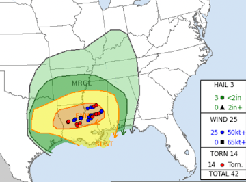
Red dots are the location of tornadoes. Blue dots are the locations of damaging winds (>60 mph). The orange "enhanced" location forecast was excellent. However, the forecast of "strong" tornadoes did not work out nor did the yellow tornado forecast area where none occurred. So, overall, it was an "overforecast" in terms of the threatened area and tornado strength.


Comments
Post a Comment