Hurricane Lee Update 10am Thursday
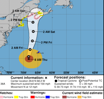
Above is the latest forecast from the National Hurricane Center. It refers to the center (eye) of the storm. H = hurricane. (S) = post tropical-storm (non-meteorologically, it is a distinction without a difference).
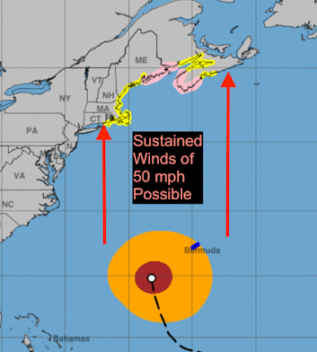
Below is the Hurricane Center's wind field (brown = 75 mph winds or stronger; amber = 40 - 74 mph winds). The wind field will spread out a little further, especially to the east of the center.
The storm will be much like 2012's Sandy in that the strongest winds, by the time it makes landfall, will not be tightly concentrated around the eye. That means everyone under a hurricane or storm warning needs to be prepared for high winds and power outages and, near the immediate coast, damage due to the surf and storm surge. There will also be a serious storm surge on Nantucket and around Cape Cod Bay. What I recommend at this point if you live in the Maritimes or in New England coastal areas:
- Get plenty of cash. ATM's and credit card readers do not work without electricity.
- If you have a gasoline-powered car, keep it filled with fuel.
- In Nor'easters, the worst winds usually come from the north through east. In this storm, the worst winds will come from south through southeast. There will also be much more of a storm surge and corresponding flooding. There will be 10-25 feet waves near shore on top of the storm surge. Please plan accordingly as they can be highly destructive.
- Put together a "go kit" in case you have to evacuate.
Remember, you can always re-deposit the money if the storm does not affect land and you'll eventually use the fuel.
I'll have another update this afternoon.


Comments
Post a Comment