UPDATED: Texas Severe Storm Update
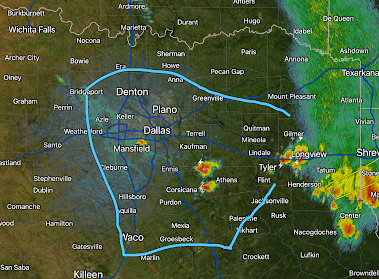
It is a hot, humid day in the Metroplex and in east Texas. If you look closely, you can see a couple of thin lines (on from Bridgeport to south of Dallas) on the northwest side of the area outlined in blue. I think that is the general area where thunderstorms will begin -- likely by 3pm.
They will spread initially in the blue area. There will be a risk of tornadoes, damaging winds and giant hail. Please monitor local media for weather warnings.
Update: 2:25pm. Thunderstorms are developing about as anticipated. The NWS's Storm Prediction Center has issued a severe thunderstorm watch. They are forecasting 3"hail and wind gusts to 75 mph! I believe there is a slight chance of a tornado or two. Once the storms develop, they should move toward the east southeast.
Again, please monitor local weather info the rest of the afternoon and evening.


Comments
Post a Comment