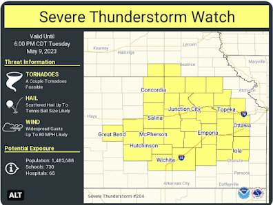
Severe Thunderstorm Watch Until 6pm
In addition to Kansas, two counties in southern Nebraska are included.
Please note what is forecasted to occur:
- A couple of tornadoes.
- Wind gusts to 80 mph. As I mentioned below, one of the computer models is predicting a peak gust of 93 mph with this weather system.
- Hail to tennis ball size. Note: when driven by strong winds, hail can be highly destructive.
Safety Measures:
- Put your car in the garage but, first, fill it will fuel as power may be out.
- Make sure your generator is ready to go and full of fuel. If you have a portable generator, keep it outdoors, away from air intakes.
- Stow lawn furniture and other items that can blow about.
- Make sure your family members and friends are aware of the risk.
- Put family heirlooms in your shelter area.
If this turns into a full-fledged derecho, there will be widespread power outages. Please prepare accordingly.
I will provide additional coverage on Twitter @usweatherexpert.


Comments
Post a Comment