Tornado and Damaging Wind Outlook: 2pm Sunday to 3am Monday
-- UPDATED FORECAST ABOVE --
 |
| nadocast.com |
The yellow area has an enhanced risk of tornadoes, especially in the late afternoon and into the early evening. The brown areas have a significant risk of tornadoes that will last into the evening (darkness). These tornadoes will be difficult, if not impossible, to see coming. So, if a tornado warning is issued do not go outside trying to see the storm. The bright green area is where I would say, "I can't rule out a tornado" but I don't think the chances require special preparation.
Damaging Wind Forecast
In my 4-category risk communication system...- Purple has an extreme risk of damaging winds, with gusts stronger than 75 mph. Power failures are quite likely.
- Red has a high risk of damaging winds with gusts stronger than 75 mph. Note: This is based on the Storm Prediction Center's forecast. I do believe the "red" risk should be taken an additional 1-2 counties farther north in Kansas. Power failures are possible.
- The yellow area in southwest Missouri and northwest Arkansas (hatching) has an enhanced risk of thunderstorm wind gusts stronger than 60 mph.
- The unhatched yellow area has a significant risk of gusts above 60 mph.
Advice For People in the Forecast Path
Given that we are moving into "tornado season..."
Make sure you have at least two independent sources of storm warnings! The forward motion of these storms will be 50-60mph, so if tornado warning or a warning of winds 80 mph or stronger is issued, there will be no time to lose -- get to shelter immediately.
Because the threat will continue after dark, I recommend StormWarn. It will call you if your home is in the path of a tornado or damaging winds (≥80 mph) for just $25/year. I make no money from your subscription; but I helped design it and believe in it. It allows you to retire for the night knowing that if the NWS issues a warning for dangerous conditions, you will receive via phone.
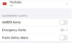
I also recommend activating the FCC's Wireless Emergency Alerts (WEA) on your smartphone. If you have an iPhone, go to "Notifications" and scroll down. Below is the way to get storm warnings and very little else (the way I want it).
Another good source is the AccuWeather App, which tracks your position and gives you warnings based on your current location. It is free, but there are advertisements. Once you have your warnings set up:
- If you have infirm friends or relatives, make provisions for them when a tornado or severe thunderstorm watch is issued. The storms will be far to fast for you to drive somewhere when a warning is issued.
- If you are in the areas with a relatively high risk of power failures, make sure your auto is fueled, that you have plenty of cash, and if you have medicines that require refrigeration, that you have a way to make sure they stay cold.
Discussion for Meteorologists of Sunday's Threat
This is an unusual early season situation where I am leaning on synoptic climatology to a great deal along with a study I did of conditions that breed nighttime tornadoes.
A "bomb cyclone" will occur in Kansas with pressures dropping 25 mb in just 12 hours. In the northeast third of the state, there will be an area where (for the public) pressures are forecasted to drop below 29.00 inches. Combined with very high SRH and rising evening temperatures, localized conditions may breed tornadoes along the line or any low-topped supercell ahead of the line.
The rapid pressure falls, the strong, negatively-tilted short-wave, and strong difluence aloft centered over the northern half of Oklahoma -- when combined with a strong push of dry air from west Texas -- should be enough to generate extreme surface gusts. By early evening 500mb winds into southwest Oklahoma should exceed 120 knots. With the dry air, some of that will mix downward and, when it does, gusts may exceed 80 mph.


Comments
Post a Comment