Update on the Pre-Christmas Cold Wave
[Note: there is an updated forecast. Scroll up on blog.]
Current Forecast
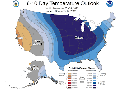
This cold wave has the potential to be as cold as the February, 2021, cold wave. If you are going to travel, especially by car, during this period, it is important to make sure you take blankets, water and a power bar (at least) for each occupant in case you should get stuck. It is also a good idea to take some sand, kitty litter, or ice melt so you can sustain yourself if you go off the road due to ice or snow.
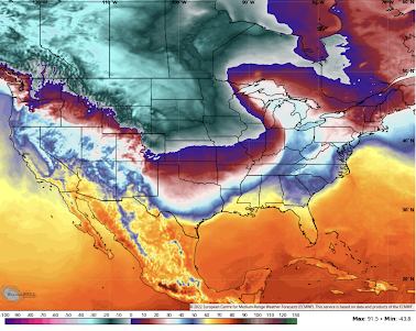
At 6pm Thursday, the cold wave is arriving along the Texas Gulf Coast and as far east as Ohio.
Meteorological Discussion
I have two strong meteorological reasons for believing this cold air mass will be stronger than forecasted by the current models:
- The temperatures in the source region of Siberia have been running as cold as -80°F. That is both extreme and slightly colder than than Valentine's 2021.
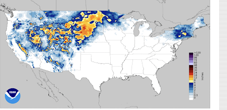
- The snow cover between here and there is much above average. See image below of the U.S. area of snow; snow is still falling in the north central states. Snow covered ground to a cold air mass is like car driving over ice: once started south, it is very hard to stop.
While the cold air outbreak for Valentine's 2021 was well forecasted starting six days in advance, the intensity of the cold wave was not adequately described until about two days before. Because this is forecast to occur near and during Christmas (with its extensive travel), I -- and a few other meteorologists -- are going out on a limb and forecasting what we believe the potential to be because we don't want people to be unprepared.
I may be wrong. There were at least two meteorologists on Twitter yesterday criticizing those of us who are "sounding the alarm." The problem with the conservative forecast technique, in this case, is that we risk catching people off guard hundreds of miles from home.


Comments
Post a Comment