4pm Winter Storm, Cold Wave, and Airport Delay Update
Temperatures as of 3pm CST
Forecast Temperatures as of 9pm CST
Forecast Temperatures as of 8am CST Friday
Forecast Temperatures as of 5pm CST Friday
NYC -LaGuardia: 1 hour, 22 minutes
NYC - JFK: 2 hours, 10 minutes
Reagan - Washington: 33 minutes
Chicago - O'Hare: 2 hours, 20 minutes
Philadelphia: 18 minutes
Toronto: 36 minutes
Sioux Falls - Airport closed due to blizzard.
The FAA is monitoring Memphis, DFW and Louisville for possible delay program implementation.
Go online and check with your airline before going to the airport.
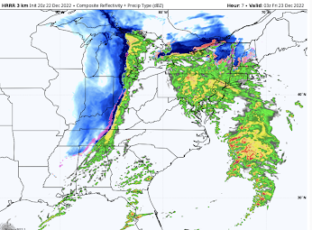
Radar as of 3:44pm CST.
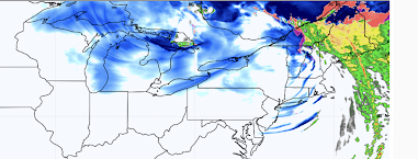
Forecast Radar as of 9pm CST
Darker blues mean heavier falling snow. Winds will be increasing in the Northeast which means blizzard conditions. The pinks and oranges are icy conditions.
Forecast Radar as of 8am CST Friday
Forecast Radar as of 5pm CST Friday
With the exception of eastern New England, the snow has converted to the lake effect type. Blizzard conditions are forecasted in a number of areas (please see below).
With the exception of eastern New England, the snow has converted to the lake effect type. Blizzard conditions are forecasted in a number of areas (please see below).
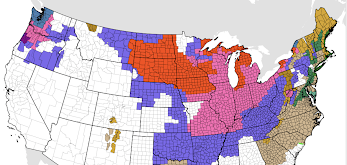
National Weather Service Warnings and Watches
Please note the ice storm forecasted for parts of Washington and Oregon, including metro Seattle and Portland. The above map is as of 3:40pm CST.
Note: Moments after posting this set of forecasts, the NWS extended the winter storm warning (below).
Here is a list of the colors.
- Orange = blizzard warning
- Pink = winter storm warning
- Dark green = winter storm watch
- Purple = winter weather advisory (a lesser condition than a warning)
- Gold/Brown = high wind forecast. Damaging winds possible in New England.
- BlueGray = extreme cold warning
- Purple = ice storm warning.
- Dark Turquoise (near Seattle) = winter storm watch (due to ice storm).
- Green = flood forecast.


Comments
Post a Comment