Posts

Showing posts from December, 2022

Three-Day California Precipitation to 4pm PST

Image
Desperately needed rain falls in Northern California. Over the next few days, the rain will shift to the south. 

National Weather Service Watches and Warnings

Image
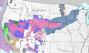
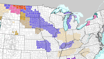
Color codes: Greens: flood forecasts and advisories Pink: winter storm warning Dark blue = winter weather watch  Purple = winter weather advisory (lesser condition) Gray = dense fog advisory  Bright blue = avalanche warning (Colorado) Amber = high wind forecast Orange = avalanche watch (Colorado) Please check the weather before you travel in this area between tonight and Monday night.

Go Kansas State Wildcats!

I expect the 'Cats to do well today.  Those were famous last words. It is one of the rare times when I believe the game turned on bad decisions by the coaches. We should have settled for three at the end of the first half and the decision to try an onside kick to start the second was ridiculous.  That said, I believe Kansas State has a great coach that will take the team far in the future. 

Snow, Ice and Tornado Forecast

Image
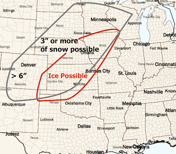
Snow Forecast This is the forecast for snow between today and 6am Tuesday. There will be accumulating snow at the Salt Lake City Airport tonight through Sunday night and at the Denver Airport on Monday and Monday night. Many cross-country interstate highways will be affected.  Ice Forecast Travel conditions will be hazardous due to freezing rain in the areas shown above. Particularly affected will be I-35 between Des Moines and Minneapolis and I-90 + I-94 in Minnesota and Wisconsin.  Tornadoes There is a significant chance of tornadoes in the yellow area Monday. There is an enhanced risk in the red area with the hatched area where strong  tornadoes are forecasted to occur. 

Mission Creep? CDC?

Image
This has been obvious for a decade (see below, from this blog in 2012). There were times in the early teens where they were publishing real-time tornado information. It was obvious they had lost their way. The Centers for Disease Control published a great deal of mis-information during COVID and seemed to be caught flat-footed.  I hope CDC will get some new leadership that realizes the agency has just one job. 

Major Storm to Start the New Year - Updated Friday Afternoon

Image
Scroll up for an updated forecast Major Winter Storm Likely;  Tornadoes Possible First of the Week Updated Friday 3:50pm The map below is unchanged from yesterday. The snow and ice areas are likely too large. I will narrow them down tomorrow when I have better data (the storm system is still out over the ocean).  This forecast of the location of possible tornadoes and severe thunderstorms with large hail and damaging winds has been updated. The forecast is valid from 6am Monday to 6am Tuesday.  Again, these forecasts are pretty far into the future and the locations will probably have to be adjusted.  If you are traveling, please monitor the weather and adjust your travel plans, if necessary. Please make sure your friends and family are aware. 

I Had No Idea the Opposition to Wind Energy was Growing So Quickly

Image
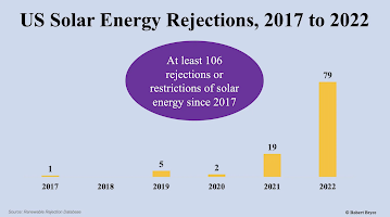
From a piece by Robert Bryce , published yesterday: ...state of Vermont, where  no new wind projects  are being built. Why not? Simple: Vermonters hate wind turbines. Or ... look at New York, a state where big renewable projects are so unpopular that bureaucrats in Albany are aiming to override local zoning laws to force communities to accept wind and solar projects. Or he could look at California, a state with an aggressive “clean” electricity mandate, where the amount of installed wind capacity has been stuck at  about 6,000 megawatts since 2015 . Why hasn’t it grown? Californians are like Vermonters: they don’t want giant wind projects in their neighborhoods. Of course, we've written about the huge, and recently cancelled, off-shore wind project in Massachusetts .  Blue State + Blue State + Blue State + Blue State.  It is just amazing that these states, especially New York, have people that urge us  to put up with expensive and unreliable wind power when...

Wyoming and Kansas Report In: Wind Energy Collapsed During Cold Wave

Image
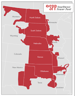
This report from Wyoming on its near blackout during the recent cold wave and winter storm.  Lee Boughey, a spokesperson for Tri-State Electric Generation and Transmission Association, said the nonprofit, which provides power to eight electric cooperatives across Wyoming, planned for the impacts of the storm as it approached.  They anticipated higher demand from member utilities in Colorado, Nebraska and Wyoming, and Tri-State prepared for wind energy resources to decline.  For safety, during extremely high winds, wind turbines will stop running and feather their blades. Icing also can cause turbines to stop running.  According to energy mix data from the Southwest Power Pool, as the storm began to move through Wyoming on Dec. 23, at 3 p.m., wind energy resources began to drop. Within 24 hours, wind energy resources were about 25% what they were prior to the storm.  They didn’t begin to rise again until Christmas morning.  To compensate for the decline i...

Need Stock Photography Related to Weather and Nature?

I hope you will take a few minutes to check out my collection at Adobe Stock Photography. Please also feel free to look if you'd just like to view some nice weather photography. Thank you. 

Attention: Returning Holiday Travelers

Image
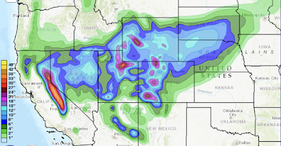
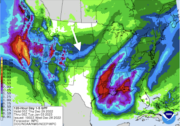
Here is the forecast precipitation between 6pm CST this evening to 6pm CST on Monday, January 2nd.  As you can see, this is forecast to be a very active period. I would expect I-80 to be closed across the Sierra at least once. I also believe the snow band across the Great Plains (arrow) may end up occurring at least a bit father south than indicated.  Given the meltdown at Southwest Airlines , I would be extremely reluctant to fly them during this period with at least two more coast-to-coast storms on tap. I would also be proactive and have "Plan B" reservations in mind in case yours get cancelled (i.e., you'll find airline reps are often happier if you have something in mind rather than asking them to fish the reservation system for you), regardless of airline. While the timing during a holiday travel period is lousy, it is great that this moisture will put a significant dent in the drought in the West.  Also, thunderstorms, some strong, will be numerous in the area outl...

"Unforeseen Storm"? You're Kidding, Right?!

Image
"That's our story and we're sticking to it!" seems to be Southwest's (SWA) strategy of blaming "unforeseen weather" for their operational meltdowns.  I've often written about weather being the "all-purpose excuse" when businesses fail their customers or fail to meet organizational goals. But, Southwest's continuing to offer weather as an excuse for their current meltdown is particularly egregious.  This is my first forecast of the storm and cold wave back on December 8 . There was more on December 9 . To conclude the December 9 forecast, I wrote: The first forecast with detailed timing and extent of the event was December 12 . This forecast was amazingly accurate considering the event didn't begin until the 22nd. You can roll the blog back and see the extremely detailed forecasts between the 12th and 22nd. I believe you will be impressed. SWA has an internal meteorology department. It is unthinkable they missed this event. If I were...

Guest Column: Climate and Energy By Dr. Judith Curry

Dr. Judith Curry is one of the world's most esteemed climate scientists. Earlier in her career, she believed global warming was an emergency. Over time, as data accumulated, she has come to believe that -- while it is a problem to be managed -- it is not an existential crisis.  Her column, published on her blog earlier today, on the topic of energy and climate. is excellent. I'm very pleased she gave me permission to reproduce it below.  The faux urgency of the climate crisis is giving us no time or space to build a secure energy future Posted on   December 27, 2022   by Judith Curry There is a growing realization that emissions and temperature targets are now detached from the issues of human well-being and the development of our 21st century world. JC note:   this is the text of my op-ed for SkyNews that was published several weeks ago For the past two centuries, fossil fuels have fueled humanity’s progress, improving standards of living and increasing the lif...

It Isn't a Mystery: The Culprit is [Lack of] Wind Energy...

Image
...and, to a lesser extent, solar; along with the recent phenomenon of electrical "marketers" who are not in the utility industry.  Texas is the #1 state for wind energy. When it fails, as it did Saturday, they are in serious trouble as they were during the Valentine's Day energy catastrophe is 2021. Midday Saturday, wind energy dropped to less than 3% of capacity in the Lone Star State. Texas has its own power grid. Nashville and Tennessee are served by the federal government's Tennessee Valley Authority (TVA). The problem there is that temperatures were unusually cold over the eastern power grid. In Kansas Saturday (#2 state for wind), the winds were nearly calm. The same was true in nearby sections of Nebraska and Oklahoma. There just wasn't any power to send east.  Map of the three grids that serve North America When you combine that with the "power marketers" (people who sell power without the backing of physical resources), you have a recipe for di...

Oh, Good Grief!!

Image
This is so ridiculous, it deserves no further comment. 

If You are Traveling Tonight or Tomorrow...

Image
...there are several areas of concern, weatherwise. Here are the color codes: Orange = blizzard warning. Pink = winter storm warning.  Purple = winter weather advisory* Green = freezing fog advisory The winter weather advisory for parts of eastern Kansas is for freezing rain. Any freezing rain can make roads hazardous. Far northeast Kansas and Missouri is expecting snow. 

Torrential Rains Forecasted for the West

Image
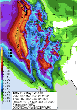
Desperately needed rain is forecasted in the West this week. Unfortunately, there will be flooding in places, but there is no such thing as breaking a severe drought with gentle rains. Right now, flooding is the lesser of the two evils. 

Have Yourself a Wonderful Christmas!!

Image
To all of our readers,  we hope you have the best Christmas ever.  I hope all of your family members made it to your celebrations safely. If there is any way to do so, please consider going to church to thank God for our immense blessings. There are many who have labored to bring Christmas to those less fortunate. They deserve our thanks.  While you are in church, say a brief prayer for meteorologists. Most all forecast operations have as many meteorologists working today as any other day. Our field often does not get the respect it deserves.  Early last week, during the storm coverage, we passed the eight million page view mark since 2013. While it says "all time," there was no counter from the start of the blog in 2009 to 2013. I guesstimate that we've had more than ten million views since the blog began.  Thanks to all of our readers. 

The Chiefs Won Today in Front of Especially Well-Dressed Fans

Image

For Those Doing Last Minute Christmas Shopping For Me...

Image
....I prefer the Lionel type. 

Unfortunate Vindication

Image
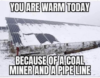
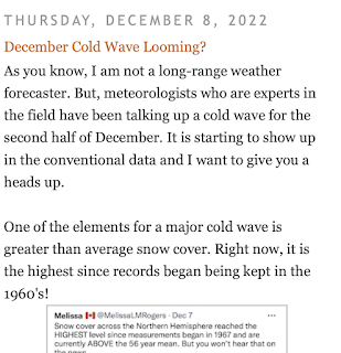
Those of us who have been pleading that politicians listen to our factual presentations that 'renewables' were making the grid unreliable have been -- unfortunately! -- hugely vindicated today. It gives me no pleasure to state this.  When the grid is so fragile that turning on stadium lights (the delayed kickoff of the Titans game in Nashville this afternoon) risks crashing the system, it is all proof that is needed: America's power grid is crumbling to third-world status. There is no quick fix because more wind farms are being erected every day. The next snow, just like this last, will cover existing and future solar panels rendering them useless in winter's cold. [Addition] I had correspondence with a reporter this afternoon. She indicated the people she spoke to were surprised about the electrical issues from the cold wave. I directed her to this screen capture of a portion of my December 13 cold wave forecast. That's ten days advance notice! [Original Text] As w...

The Appalling State of America's Electric Grid

Image
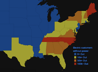
As of 9am, here is a map of power failures across the Lower 48. In many areas in the Northeast, the high winds are responsible for the outage. But, in the South, it is poor planning ("we didn't know it was going to be this cold") and, you guessed it, renewables.  From this morning's Nashville Tennessean ,  "Demand ran 35% higher than a normal winter day."  Remember how yesterday I wrote about how we forecasted this extreme cold wave an amazing 13 days  in advance? I also wrote, It is hard to believe that they claim they were expecting a "normal winter day." And, it isn't just Nashville. Once we ignore the spin, I suspect there were two problems: Thanks to wind and solar, we no longer have excess capacity. As during the Texas 2021 power catastrophe, there isn't enough power anymore, especially when (as happened in Texas) wind drops to 2% of capacity. They didn't believe the weather forecasts in time to maximize the power they had. From ...

Modern Meteorology -- A Vital, But Underused, Tool

Image
The economic loss and human casualties from the major storm and cold wave now winding down are still to be totaled, there is no question that they are much lower than they would have been 150 years ago before the science of meteorology began.  The conditions with this storm -- extremely cold air with a rapid drop in temperature -- have, in the past, resulted in horrendous loss of lives. For example, "The Children's Blizzard" of 1888 took a stunning 235 lives. The snow amounts in the Great Plains in '88 were not that great -- the maximum was just six inches. But the extreme cold and high winds combined with greatly reduced visibility caused the children to become lost. There were thousands of children walking home from school at the time and they were caught, unaware, in those extreme conditions. Many died from exposure.  That was certainly not the case with this storm. I made my first post about the cold wave on this blog on December 8 , 13 days before the start of th...

9:50am CST Winter Storm Update

Image
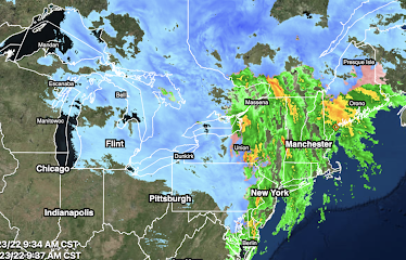
The major storm is causing havoc to transportation and to the general public as it has moved east. High winds are occurring throughout New England. Burlington has recorded a gust to 70 mph, the second highest gust ever recorded at that weather station.  A map of the current power outages is below. I have gone to the FAA's web site and it should be assumed that all of the areas showing rain or snow on the radar have significant delays. Of course, these delays cascade through the system. If you are trying to fly today, I would urge you to go online (don't try to call) and check the status of your flight. According to the news media, 3,000 flights have been cancelled.  The West isn't without troubles.  Because of the mountains, the radar algorithm is having issues with precipitation type in Washington. There are more areas that are receiving freezing rain (pink/orange) than shown. There are power outages as a result.  Finally, there are areas of snow and rain in the Sou...