Heat Island and Snow Forecasting
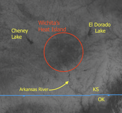
The above satellite photo shows snow in white with heavier snow appearing whiter. But, if you look in the center, there is less "white" than in surrounding areas. That is due to Wichita's "head island." A heat island is an area of relatively warmer air caused by urbanization and it drives meteorologists nuts when trying to forecast snow amounts in a borderline situation like yesterday's.
Heat islands are also an issue with climate studies as, in many parts of the world, the only temperatures sensors are in or near cities. As cities grow, the heat island becomes more extensive. Correcting for this bias is controversial in climate research.
A couple of other items: You can see the spine of the Flint Hills in the east (right) part of the photo. Trace the whitest area from "KS" to "El Dorado Lake." The rivers flow away from the highest elevation. In a situation like yesterday's, the higher elevation accumulates a little more snow. The meteorological computer models are getting to be high enough resolution that we now sometimes see the "Flint Hills effect" in their output.


Comments
Post a Comment