Posts

Showing posts from November, 2022

How Did the Tornado Forecast Work Out?
Image
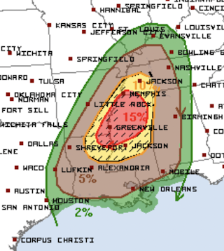
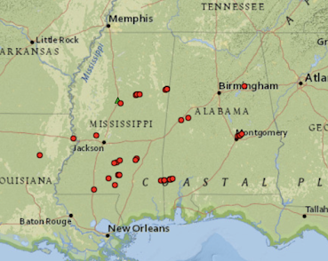
As we usually do after a major forecast, here is an evaluation of the tornado forecasts for the event that was in progress 24-hours ago.  Above is a map of the tornadoes (red) reported, so far, which number 37. Inevitably, when the local NWS offices finish their surveys, there will be more. This is especially true since there were 83 reports of wind damage (blue, see map below). Some of those will be converted to tornado damage when the surveys are complete.  Here is the SPC forecast for comparison.  And, here are the tornado reports plotted on top of the forecast. While the 15% was the maximum correct value, it was placed too far to the northwest. What may not have been correct was the hatching. So far, there have not been many reports of EF-2 or stronger intensity tornadoes. The 5% (brown) was way too far north.  Still, this was -- overall -- a good forecast. I would give it a B.  The upgrade to "high risk" on my scale because of the tornadoes in darkness thre...

Climate and Rainbows: Will the Climate Absurdity Never End?

Image
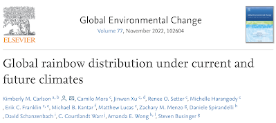
A forecast of how rainbows will change in the next 78 years. 🙄 Taxpayers in both the United States and Great Britain evidently paid for this peer-reviewed paper.  First, who cares?! Second, weather forecasts 78 years in the future? Absurd.  That is hardly the only recent global warming silliness. See below from CNN. The nonsense doesn't stop! Of course, this is the same publication that told us in March, 2000, that "children aren't going to know what snow is." Today, if you attempt to look up that infamous article, you get, "We can't find that page*." No matter how many times the zealots are wrong , it never diminishes their confidence and self-righteousness.  NOTE: This one came out today, after the above was posted. Global warming: Is there anything it can't do?! * FYI: While I occasionally will delete a routine forecast to reduce clutter, I do never delete other content, including forecasts that are incorrect 

Extraordinary: PDS Tornado Watch Extended Well After Midnight

Image
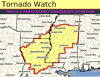
I can't remember in the last decade when a "particularly dangerous situation" tornado watch has been extended as late as 2 am. It is important to insure that you have a way of receiving tornado warnings after you retire.  Note: this will be my last update on this storm. 

3:40pm Tornado Threat Update

Image
A "particularly dangerous situation" tornado watch continues until 7pm. Please continue to closely monitor the weather in this area. Beyond 7pm, here is the forecast (via @nadocast) for strong tornadoes between now and 7am Wednesday. If you live in the black, red, or purple areas, you are at risk of a damaging tornado. Again, please continue to monitor the weather.  As of 3:32pm, here are the tornado warnings (red) and severe thunderstorm warnings (yellow).

PDS Tornado Watch Until 7pm

Image
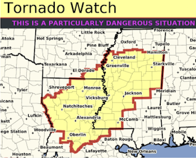
PDS = "particularly dangerous situation," which a rare  tornado watch. There are entire years without one being issued. The NWS says, "numerous strong tornadoes" are forecast to occur.  In addition, hail up to 2" and thunderstorm-generated wind gusts up to 70 mph are forecast. Now is the time for people to begin watching the weather continuously in this area. If you live in a mobile home, find other shelter.  You may follow me on Twitter:   @usweatherexpert .  I will only be tweeting intermittently but I will provide updates when possible. 

Extreme Tornado Risk: "Particularly Dangerous Situation"

Image
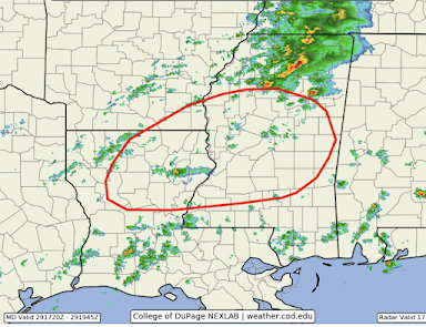
11:18am radar along with red forecast The NWS Storm Prediction Center has just put out a blurb informing us that they are going to issue a very rare "particularly dangerous situation" tornado watch in the area outlined in red.  The dangerous thunderstorms will begin to develop around 1pm and tornadoes should be developing by around 2 o'clock.  It is essential that you have your tornado preparations completed by that time.  If you live in a mobile home without a shelter, find other shelter now. Make sure your shelter area has any cobwebs, etc., cleared out. Put in a couple of bottles of water.  Wear shoes into the shelter area. Have at least two independent sources of tornado warnings.  If you wish to be able to depend on being awakened during the night if you are in a tornado warning or if you are busy and can't continuously monitor the weather, please sign up for  StormWarn . For just $25 per year, you'll get a phone call 24 hours a day if you are in the...

High Tornado Danger This Afternoon and Tonight in the South

Image
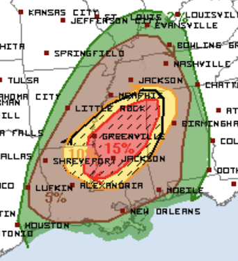
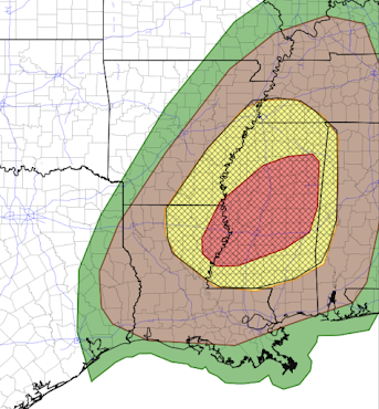
A Day Where it is Essential to Monitor the Weather Life-threatening, destructive tornadoes are likely to occur. The above map from the NWS SPC depicts a tornado outbreak with the risk beginning around 1-2pm today through the pre-dawn hours on Wednesday. Here is what the map, from the NWS's Storm Prediction Center, forecasts using may 4-level scale: Brown, significant risk of tornadoes. Yellow, an enhanced risk of tornadoes and the hatching indicates some of the tornadoes could be strong.  Red, a high risk of tornadoes. The hatching indicates some could be strong.  To better narrow down where the highest risk of destructive tornadoes exists, consider the experimental map below. It depicts the probability of strong and violent tornadoes.  @nadocast on Twitter The red and purple areas are at very high risk of strong tornadoes.  Now is time to double check your tornado procedures and make sure your shelter area is ready to go. Also, make sure you have at least  two...

Today's Tornado Forecast

Image
While hail up to 2 inches in diameter and thunderstorm-generated wind gusts of 60 mph or stronger are possible with the severe thunderstorms, I want to focus on the tornado threat because there is a real chance that strong tornadoes will occur this afternoon and tonight.  The tornado threat, and especially the strong tornado threat, has been shifted to the south.  This forecast, from the NWS's Storm Prediction Center, shows where tornadoes are likely to between about 1-2pm on the west to about 4am (on the east, I've cut the graphic off where I believe the tornado risk ends tonight). Here is the threat translated to my four-point scale: Brown, significant risk of tornadoes. Yellow, an enhanced risk of tornadoes and the hatching indicates some of the tornadoes could be strong.  Red, a high risk of tornadoes. The hatching indicates some could be strong.  However, my personal opinion of where the highest threat for strong tornadoes matches a web-based forecast called "Na...

9: 50pm Quick Update Pertaining to Tomorrow's Tornado Threat

Image
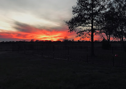
Photo by Kathleen Smith Tonight's Wichita sunset (above) featured clouds in the western sky that are on the leading edge of the storm that will trigger tornadoes and severe thunderstorms in the south central United States tomorrow afternoon and night.  To refresh your memory, below is the NWS SPC's current forecast of a tornado outbreak in the South tomorrow. The evening data is coming in and my current thinking is that this forecast may need to be shifted about 100 miles to the south. For now, if I were in Jackson, Monroe and Hattiesburg, I would consider myself to be in a high tornado risk region and prepare accordingly.  Of course, I will update all of this in the morning. 

Drought Update and Rainfall Outlook

Image
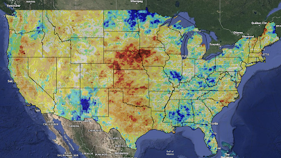
Here is the latest Palmer Drought Index with data as of November 21.  The darker red areas indicate more severe drought. The more blue an area, the wetter it is.  Here is the NWS's precipitation amount forecast for the next seven days.  Here is the NWS's 6 to 10 day precipitation forecast. While this rain will be helpful in the West, it will be unhelpful in the Ohio Valley which is already too wet.  As the Palmer Drought Index shows, the severe drought from Nebraska and Iowa south to Texas is where ran or snow is needed the most and five-day amounts are generally light to moderate in that region.  And, for days 11-15, here is the European model (the best in the world, but there can be large variations between the forecast and the actual amounts that far into the future).  On a related topic, there are indications in both the data and the models that a prolonged cold wave may move into the Lower 48, especially the eastern half, by mid-December. Please keep t...

Possible Tornado Outbreak Tuesday Afternoon and Night

Image
Please see 9:55pm update (above). -- original post below -- The above map depicts a tornado outbreak with the risk beginning around noon Tuesday through the pre-dawn hours on Wednesday. Here is what the map, from the NWS's Storm Prediction Center, forecasts using may 4-level scale: Brown, significant risk of tornadoes. Yellow, an enhanced risk of tornadoes and the hatching indicates some of the tornadoes could be strong.  Red, a high risk of tornadoes. The hatching indicates some could be strong.  Now, while the weather is still nice, is time to double check your tornado procedures and make sure your shelter area is ready to go.  Because there is a high risk of tornadoes during darkness, it is time to seriously consider StormWarn . For just $25 per year, you'll get a phone call 24 hours a day if you are in the direct path  of the tornado but only  if you are in the direct path. Unlike a weather radio, you will not be awakened for a forecast of hail 20 miles away...

British Medical Journal: "FDA Oversight of Clinical Trials is “Grossly Inadequate,” Say Experts"

Image
In a blockbuster report that, at least indirectly, bears on the safety of the COVID vaccines, the respected British Medical Journal has a scathing investigative report on how the U.S. Food and Drug Administration (FDA) doesn't do its job when overseeing the development of new drugs. You can read the report here .  Sometimes I wonder if we wouldn't be better off without the SEC (which rarely does its job) and the other government agencies that we think  are protecting us (but aren't). If the "alphabet agencies" didn't exist, perhaps better, private sector, alternatives would develop.

"Cost of Wind Energy Has Doubled in Three Years"

Image
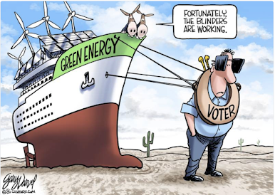
One of Big Climate's biggest lies is that wind energy lowers electric bills. Those of us condemned to live in states with a high amount of this nonsense have seen our electric bills soar.  Not only do we have high rates, when we had extreme cold in February, 2021, we had blackouts, too. This had never before happened in Kansas, including in December, 1983, when we had the "coldest two weeks in the history of the state." In those days we were relying almost entirely on coal.  As John Hinderaker writes , The average cost of electricity generated by wind turbines has almost doubled in three years, and yet governments continue their irrational policies that can only drive the cost of power higher. The one thing that could make the situation catastrophically worse is if governments imposed drastic new demand on the electric power grid by making us all drive electric vehicles. But no, they could never be that stupid. Could they? Massachusetts, which uses almost no wind energy, ...

Lower Mississippi Valley Tornado Risk Tuesday

Image
While the greatest threat may shift a bit in any direction, the yellow -- and especially, orange -- areas have an enhanced risk of tornadoes on Tuesday and Tuesday night. Some of the tornadoes may be strong.  Because this is completely out-of-season, I wanted to give you this heads up. I will update on this tomorrow afternoon and will also provide coverage on Tuesday.   

Rain Across the Winter Wheat Belt

Image
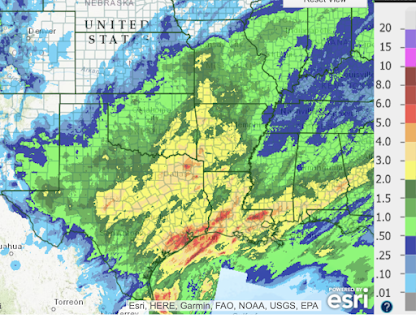
Here is the 7-day rainfall, most of which fell in the last three days, across the winter wheat belt. The rains were quite helpful in southern Oklahoma and Texas wheat areas (outside of the Panhandles) but not so much in Kansas and Colorado.  While the month of November is not quite finished, here is a map of the difference from normal average rainfalls for the past 30 days. 

Meteorologists and State Licensing

Image
There is a surprisingly lively discussion on Twitter today pertaining to whether meteorologists should be required have degrees or even occupational licenses. Currently, no state nor the federal government licenses us. You can read the discussion here . The downside of this is that anyone can call themselves a "meteorologist." I believe that, in general, too many occupations require licensing. It absurd that many states require a license to wash hair.  In meteorology, I do not  think there should be licensing for forecasting. Where I believe licensing should perhaps be required is for storm warnings; tornado warnings, ice storm warnings, hurricane warnings, et cetera. These are literally life and death situations and there are people who issue their own tornado warnings who have few to no formal qualifications.  While there is no licensing, the American Meteorological Society has its certified consulting meteorologist program along with its certified broadcast meteorologi...

Congratulations, Kansas State Wildcats

Image
The job done by Coach Chris Klieman at Kansas State is phenomenal. His first year at KSU was 2019 and then COVID hit. He managed it beautifully and has produced a team (picked to finish second to last in the Big 12) headed for the championship game. Win or lose, he has done an amazing job.

Heads Up: Gulf Coast Tornado Risk

Image
The brown area has a significant risk of tornadoes later today and tonight. Please keep an eye on local weather warnings. 

How Far State of Kansas Football Has Come

Image
I can't remember if the two largest Kansas universities have ever had the national prime-time spot before. 

Post Thanksgiving Travel Weather Forecast

Image
Below is the forecast precipitation from 6pm Friday to 6pm Saturday. Here is the forecast radar for 5pm CST Saturday. Here is the forecast radar for 5pm Sunday

Precipitation the Next Five Days

Image
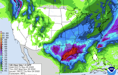
Heavy rains will continue along the Gulf Coast the next 36 hours. Heavy snow will fall in the Cascades. Needed rain will fall in the southern winter wheat belt. 

Hope You Have a Wonderful Thanksgiving

I've always felt Thanksgiving -- the day set aside to give thanks to God for our abundant blessings in the United States -- is an under-appreciated occasion.  As Virginia Postrel writes, The original Mayflower’s sails were probably woven with around 30 threads to the inch in each direction. If, like the replica, they used 3,800 square feet of fabric, they would have taken nearly a million yards of yarn. Before the Industrial Revolution, just spinning that much yarn required about two years of work. That doesn’t include the laborious process of harvesting and preparing the plant fibers. Nor does it include weaving on looms powered entirely by the weavers’ muscles... Our closets and drawers bulge with clothing in every imaginable color. Thanks to incremental improvements over the past few decades, our clothes resist stains and wrinkles in ways that would thrill the past’s laundry-weary housewives. T-shirts wick sweat, and raincoats shed water. Sweaters snap back into shape, and pants...

Attention Editors and Photographers

Image
With a rail strike looming, you may wish to review my photos relating to railroading. Samples: Adobe Stock Photography : Shutterstock :

Another Global Warming Meeting Bites the Dust

Image
COP27 is over.  The private jets have departed  from Egypt.  The steak and salmon leftovers  are in the garbage.  An agreement to "save the world" (translated: fill our coffers and increase our power) was not reached, so we'll do it all over again in two years in Dubai (notice that these are always exotic, luxurious locales?). Remember: it is your tax dollars that are being spent for all of this!

First Look at Post-Thanksgiving Travel

Image
Current Travel Problems in the Northwest Purple is a winter weather advisory and gray is dense fog advisories. These are currently in effect. No major issues expected tomorrow (Wednesday). Precipitation for the 24-hours ending at 6pm CST Saturday Snow Temperatures at 6pm Precipitation for the 24-hours ending at 6pm CST Sunday Snow Temperatures at 6pm Please note the plunge of cold air moving south through the Great Plains and Rockies. There is good reason to believe there could be a period of extremely cold weather in December. I'll have more on that as we get closer.