UPDATED: Tropical Storm Kay Affects Southern California
 |
| 8:30am PDT |
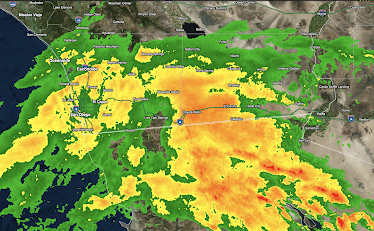
I have also updated the radar image at bottom as of 8:30am.
Second update: As of 9:30am PDT, the NWS is forecasting an additional 2-4 inches of rain in the mountains encompassed by the red area below.
-- Original Post --
There is a serious risk of flash flooding in the red area where as much as five inches of rain is forecasted to occur.
Keep in mind that you should never cross a flooded area by foot or by car! In addition, high winds will affect the region, including I-8 (especially) and I-10. Gusts may reach 70 mph near Alpine along I-8. This will be dangerous for trucks, RV's and other high-profile vehicles. A gust of 58 mph has already been recorded at Otay Mountain.
While this will be a brush-by from Tropical Storm Kay, keep in mind the Southern California is struck, on average, by a full-fledged hurricane about once every hundred years. The last was 1937.
Below is the radar from 8:38am PDT. The rain is moving north northwest.


Comments
Post a Comment