Hurricane Ian's Forecast Fiasco
--- Bumped because of the additions below --
I am sorry to have to report that the National Hurricane Center’s (NHC) forecasts of Hurricane Ian left a great deal to be desired.
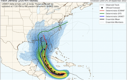
Yet again, the European Global Weather Model (ECMWF) did a far, better job with the hurricane than the USA’s model. So did the British UKMET model. The Hurricane Center, as meteorologists sometime say, “went model chasing" in its forecasts.
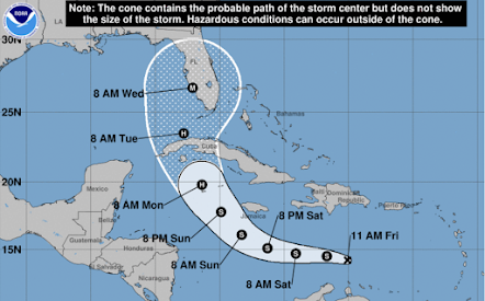
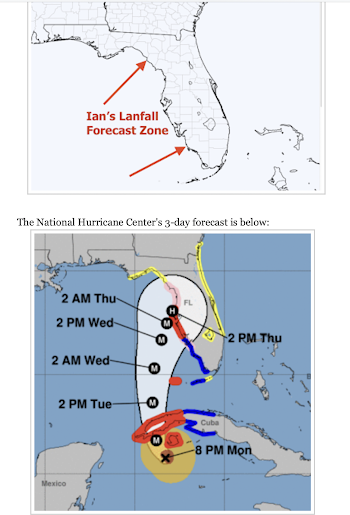
On Friday (23rd), NHC had the forecast for Ian correct. It was nearly perfect -- and should have been left alone. M = major hurricane (Cat 3 or stronger get) in the correct area.
Unfortunately, the Hurricane Center allowed its judgment to be influenced by the often defective National Weather Service “GFS” model which took Ian on an excursion to the Alabama – Florida border – which was 400 miles from the eventual point of landfall.
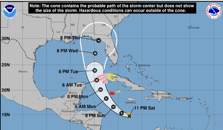
The Center split the difference between ECMWF/UKMET and the GFS. So, the center’s forecast by 11pm Saturday moved the point of landfall
to the Florida Big Bend (above). Some members of the GFS Ensemble (thin, gray lines) had landfall in Louisiana! The eventual point of landfall was slightly outside of the white “cone” (above).
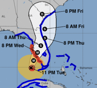
The National Hurricane Center didn’t revert its forecast back to one that was essentially correct until Tuesday evening at 11 pm (below) -- just 14 hours before landfall. The fact it was at night made last minute evacuations chancy.
The high death toll from Ian (150) may have been a result of the forecast confusion.
The nearly four days of inferior forecasts cost our nation in other ways.
- The first was evacuating people who did not need to be evacuated. That cost them money in terms of hotels, gasoline, etc. and, perhaps, lost wages due to taking time off from work.
- The second was shutting down businesses unnecessarily.
- The third was the hit to the reputation of weather science. Will people who unnecessarily evacuated for Ian evacuate the next time? And, what about the people in flooded Naples, quoted on newspaper websites, that said they didn’t have enough notice?
For a full decade, the NWS has been promising to fix these GFS issues and have not. The agency has an internal culture problem where it often rejects outside suggestions and even technical assistance.
I'm hardly the only one to notice these issues. Dr. Cliff Mass of the University of Washington meteorology department has written a blog piece on these issues. I wholeheartedly agree with what he has written.
The chances of the NWS/NOAA fixing the GFS model, deteriorating tornado warnings, and the rest of the ever-growing number of issues facing it are nil. They've had a decade and the problems have only worsened.
This is why the United States desperately needs a National Disaster Review Board (NDRB). As with the National Transportation Safety Board does with airline or rail accidents, the NDRB would evaluate the performance of the NWS, FEMA, the Red Cross and others after one of these giant storms. It would make solid recommendations as to improvements.
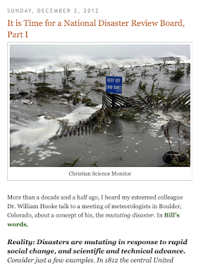
After the Sandy fiasco, I proposed a National Disaster Review Board on December 2, 2012.
The National Weather Services’ poor model made national news after Hurricane Sandy, we have a yet another fiasco for exactly the same reason, in spite of the NWS and NOAA’s assurances that all would be well. Dr. Cliff Mass of the University of Washington meteorology department has come to a similar conclusion. In order to fix the problem, we can’t depend on NWS or NOAA. He ends his excellent piece with the the following:
“it will take the active intervention of Congress to fix it.”
Cliff is absolutely correct. Please write your congressional delegation and urge them to create a National Disaster Review Board. Feel free to include a link to this post.
----
Addition: Sunday, October 2:
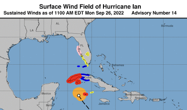
I have been asked, specifically, what was "wrong" with the forecast with regard to Lee County, Florida (Ft. Myers area). Here an explanation beginning with NHC's forecast 48 hours before landfall.
Red is hurricane warnings and blue is tropical storm warnings. In Florida, pink is a hurricane watch and yellow is a tropical storm watch which includes Lee County. No one orders evacuations for a tropical storm watch. Monday, at 8:06pm, Lee county still isn't in a hurricane warning (lower graphic).


.png)


Comments
Post a Comment