Extreme Wind: Great Plains. Tornadoes: Upper Midwest
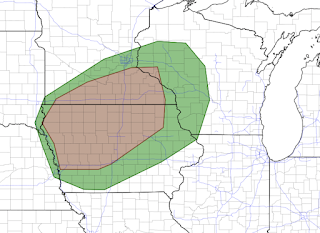
Tornado Threat
There is a significant risk of tornadoes Wednesday and Wednesday evening in the Upper Midwest.
The area that reaches the significant risk threshold is in brown. Please note: this level of threat is not nearly as ominous as Friday's. Widespread Damaging Wind Threat
In my 50+ years of doing this, it is one of the more unusual high wind situations I have seen. It needs to be taken seriously as there will be power failures -- likely widespread -- and there may be structural damage.
Here is an overview of the forecasted wind gusts. Click to enlarge.
One of the reliable computer models is forecasting 100 mph gusts (!) in the Boulder, Colorado, area.
In Kansas and the surrounding states, wind gusts may reach 85mph!
These maps should not be taken as perfect. The actual wind gust pattern may shift a little to the north or the south.
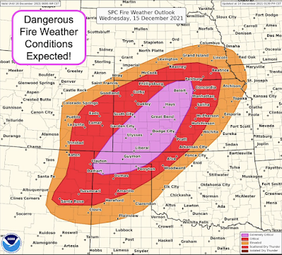
As if this weren't bad enough, the current drought combined with the wind and low humidity is calling for the most dangerous wildfire forecast ever issued for this region this time of year.
The words, "extremely critical," are an accurate characterization. These extreme winds will cause:
- Widespread, prolonged power failures.
- Extreme wildfires that will move at record speeds for the Great Plains. They will be nearly impossible to extinguish on a timely basis. Call the fire department if you suspect a wildfire!
- Blowing dust with reduced visibility.
- Tumbleweed storms. These aren't funny. If trapped in one, your car can catch fire.
What to do now?
- Bring in Christmas decorations, lawn furniture, bar-b-ques, or anything that can be blown about.
- Put your car in the garage or other shelter when you arrive home tonight.
- Charge your devices tonight. Power surges may occur tomorrow.
- Make sure friends and relatives are aware of the threat.
- If you have a friend or relative that needs a medical device and lives alone, bring them to your home tonight.
- On the way home, pick up some extra cash and fill your car with fuel.
What to do during the winds?
- Treat it like you would a severe thunderstorm warning -- stay away from windows!
- Do not drive unless there is a compelling reason to do so.
- High profile vehicles (mini-vans, semi's, etc.) should probably stay off the roads.
- If your roof is torn off or there is other serious structural damage, call 9-1-1. Do not try to handle it yourself.
To wrap up.... Summary of Warnings and Watches
- Gold = high wind warning
- Brown = high wind watch
- Maroon = high wildfire danger
- Pink = winter storm warning
- Purple = winter weather advisory (lesser condition than a warning)
- Green = flood info
- Deep green = winter storm watch
Note: there will be airline delays in Denver, Wichita, Kansas City, Des Moines and Omaha.
I will update again tomorrow morning.


Comments
Post a Comment