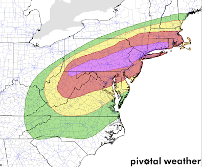
Extreme Risk of Flash Flooding in the Northeast
While this is the NWS's forecast, I choose to recharacterize the risk descriptions.
Moderate to, in places, heavy rain is falling over south central and southwest Pennsylvania. The heaviest rains in south central PA are expected to begin 4-8am Wednesday.
- Purple: Extreme risk of flash flooding.
- Red: High risk of flash flooding.
- Yellow: Medium risk.
- Green: Slight risk.
This forecast is valid from tonight through 8am Thursday. I would add Garrett, Allegany and Washington counties of Maryland into the extreme risk area.
The extreme risk is so important because 80+ of flash flood deaths occur in extreme risk areas.
Update 443p, ECMWF model shows torrential rains falling.
Here is the latest radar, 4:44pm.
Please follow local weather information for updates.


Comments
Post a Comment