Elsa Forecasted to Make Landfall Farther North
The point of landfall has been moved north since yesterday. When the storm makes landfall, the peak sustained winds are forecasted to be 65 mph -- but the location of those winds may be some distance from the center.
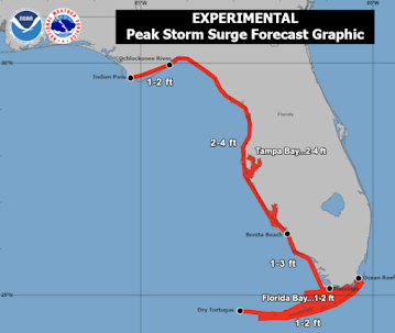
Below is the forecasted storm surge.
Please monitor local sources of weather information if you live in these areas. ADDITION:
The yellow area has an enhanced risk of tornadoes tomorrow and tomorrow night. 


Comments
Post a Comment