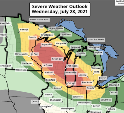
3:15pm Update on Forecast of a Destructive Derecho
Here is the latest on the destructive derecho forecasted to occur in the Upper Midwest. The storm seems to be starting its development now (see radar, below).
The "red" and "orange" threats have been extended southeast into Michigan and Indiana+Ohio, respectively. With the derecho, the following is forecasted to occur:
- Tornadoes
- Wind gusts of 90+ mph (really).
- Large hail which, when driven by wind, could cause damage by itself.
This is the forecast position of the derecho at 9-10pm this evening. It will be moving southeast.
You still have time: Here's what to do to prepare,
- Please make plans to take care of infirm family members now.
- Fully charge laptops and phones before 3pm. Unplug them before the storms arrive due to the potential for power surge damage during the storms.
- Fill your car with fuel. Know how to disconnect your garage door opener if you have one.
- Monitor local weather information.
- Tie down trampolines and bring lawn furniture in.
- Excellent additional advice is here.
As of 3:10pm CDT the first storms of what will become the derecho are developing over the Minnesota Arrowhead. Please monitor reliable local sources of weather information.


Comments
Post a Comment