Posts

Showing posts from July, 2021

Downburst and Spectacular Thunderstorm

Image
The view from my home this evening.  Nothing like the Kansas Sky! This was right at sunset and the tall cumulonimbus cloud was catching the orange rays. In the foreground is a line of towering cumulus clouds along the outflow winds caused by a downburst near the Sedgwick - Sumner county line.  Below is a closeup of the towering cumulus moving toward me.  The towering cumulus were along the leading edge of a downburst's outflow.  The curved orange line represents the northern edge of downburst winds at 8:27pm. The yellow polygon is a National Weather Service severe thunderstorm warning. 

2021's Northeast 'Tornado Alley'

Image
I note that, as of today, New Jersey, eastern Pennsylvania, Maryland, Delaware, and eastern Virginia have all had more tornado warnings than the Wichita area of south central and southeast Kansas -- by a pretty big margin. The Philadelphia NWS office has issued 29 tornado warnings. Wichita has issued 10.  In 2020, there wasn't a single  tornado in south central or southeast Kansas. 

Extreme Flash Flood Risk in Colorado Through Tonight

Image
The green areas represent flash flood watches. This includes the Denver Metro area, the Front Range and the Palmer Ridge as well as the mountains.  Every component is in place for major flash flooding. The last two weeks of July and the first two weeks of August, statistically, a period of high flash flooding.  I strongly recommend curtailing outdoor activities and unnecessary travel into the mountains and high-risk areas until this threat has ended. Unfortunately, more heavy rain is likely tomorrow and tomorrow night.  Update as of 12:45pm MDT: The radar at 12:40pm MDT, shows thunderstorms developing over the Front Range southwest of Denver and near Colorado Springs.  Please   monitor the weather in these areas the rest of the day. 

Latest Palmer Drought Index

Image
Above is the latest Palmer Drought Index with data through July 24. The drought had eased a bit in the Southwest and in Colorado. It worsened in the northern Great Plains. Meanwhile, wet conditions continue over the southeast quarter of the nation.  Below is the "departure from normal" rainfall map for the seven days ending at 7am CDT yesterday. While it is not a perfect bridge between the end of the Palmer data collection period to now, it clearly shows the heavy rains in Arizona and adjacent areas had improvement.  Unfortunately, the "departure" map shows that crop conditions worsened in the western corn belt.  More drought-easing rains are forecast for the West the next five days.

Bensalem Tornado: Another Dangerous National Weather Service Warning Miss

Image
Renewing My Call For a National Disaster Review Board As many of you know, The Washington Post  on May 21 published an essay of mine that documented the deterioration in the National Weather Service's tornado warning program . Subsequent events, some documented in this blog, have confirmed this dangerous trend of the past ten years.  Last night was one of the worst -- and most dangerous -- misses yet. It occurred with the Bensalem Tornado which struck a northeast suburb of Philadelphia with little warning. There were five injuries (severity unknown) and the damage was at least  F-2 intensity (addition: NWS rated the tornado EF-3) . Here is the sequence of events (all times EDT): At 6:49pm , there was rotation in the supercell's appendage in the north Philadelphia suburbs. I was shocked a tornado warning had not been issued. So, I outlined the rotation and advised people from there to Bensalem and beyond to keep an eye on the storm. Remember: it is the core mission of...

Major Tornadoes in the Middle Atlantic Region

Image
Pennsylvania Tornado Earlier Today Via Twitter While there will be much more data after damage surveys are completed tomorrow, I wish to bring you up-to-date on a significant tornado outbreak in the Middle Atlantic region.  Preliminary Storm Reports The red dots are preliminary tornado reports. For reasons I don't understand, the NWS in Philadelphia plotted the damage reports near and northwest of Trenton as thunderstorm wind damage rather than tornado damage (arrows). As you'll see below, it was a tornado. Please also not the tornado reports in the OH-PA-WV region.  Rotation Maps Here is a map of New Jersey and eastern Pennsylvania with rotation tracks plotted on it. Where the colors are while/blue, a tornado is nearly certain. There may also have been tornadoes in other area. The worst damage reported , so far, was in Bensalem (northeast Philadelphia suburb). It appears to be at least F-2 and, possibly, F-3 intensity. Five injuries are reported.  Other significant tor...

"The Most Terrifying Map in the World"

Image
We rarely write about economics, but this is worth including. It is from an article, The Most Terrifying Map in the World.     I completely agree this is terrifying: The political implications for freedom and prosperity for the people of the United States and world are profound.  There are many who are, correctly, concerned about wages and opportunity in our nation. I don't see how that can materially improve while our markets are shrinking across the world.  But, on an even more profound basis, China is an "evil empire" (to borrow a phrase from President Reagan) under which people do not have basic rights. And, I don't see our politicians doing anything to arrest these disturbing trends. 

"Particularly Dangerous Situation" -- "Widespread 90 mph Winds"

Image
NWS has issued a rare  particularly dangerous situation severe thunderstorm watch. They are forecasting widespread 90 mph winds, 2" hail (destructive when driven by such strong winds) and a "couple of tornadoes."  Please see the posting immediately below for last-minute safety suggestions.  This will be my last update for the night. 

3:15pm Update on Forecast of a Destructive Derecho

Image
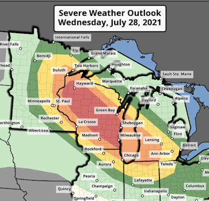
Here is the latest on the destructive derecho forecasted to occur in the Upper Midwest. The storm seems to be starting its development now (see radar, below).  The "red" and "orange" threats have been extended southeast into Michigan and Indiana+Ohio, respectively. With the derecho, the following is forecasted to occur: Tornadoes Wind gusts of 90+ mph (really).  Large hail which, when driven by wind, could cause damage by itself.  This is the forecast position of the derecho at 9-10pm this evening. It will be moving southeast. You still have time: Here's what to do to prepare, Please make plans to take care of infirm family members  now.   Fully charge laptops and phones before 3pm. Unplug them before the storms arrive due to the potential for power surge damage during the storms.  Fill your car with fuel. Know how to disconnect your garage door opener if you have one. Monitor local weather information.  Tie down trampolines and bring lawn furnit...

Dangerous Day For Wisconsin and Adjacent Areas

Image
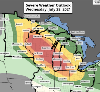
This has been updated at 3:15pm. Please see the posting immediately above.  This is going to be a dangerous period, especially in the orange and red areas. The dangerous storms will begin after 3pm and continue until 7am in Ohio. The hazards include tornadoes; destructive wind-driven hail, and wind gusts above 80 mph. A derecho -- an extremely destructive type of storm --  is likely to occur.  Please make plans to take care of infirm family members now.   Fully charge laptops and phones before 3pm. Unplug them before the storms arrive due to the potential for power surge damage during the storms.  Fill your car with fuel. Know how to disconnect your garage door opener if you have one. Monitor local weather information.  Excellent additional advice is here .  I'll update on this situation this afternoon. 

Climate Experts: "Often Wrong...Never In Doubt"

Image
UPDATED and BUMPED: Below is a piece I posted Monday pertaining to yet another nonsensical story from Yahoo!  quoting climate 'experts' that claimed the "megadrought" was terrible and it showed "no sign of letting up."  After record rainfalls in the week after the Yahoo!  story was published, the drought is "letting up."  Since the tactic of trotting out the "drought is terrible" press releases blew up their faces, the 'scientists' thought they'd try the flash flood press releases this week since that is this week's weather in the news. Who says "weather isn't climate"? 🙄  --- Monday's original posting -- Pahrump, Nevada, earlier today Well, that didn't take long. A week, specifically. The drought in the West; the "this drought is the worst, ever, ever, ever and it is due to climate change and will last for decades" -- took exactly a week to be proven wrong.  Some choice quotes from the Ju...

Time For Candor From Federal Public Health Officials

Image
Growing up in the 50's, I remember the terror regarding polio. My mother would not let us go to the swimming pool because "children who went to public pools got polio." We wanted to go because it was so hot and we had no air conditioning. Turned out, my mother and the others were right. Polio was overwhelmingly spread through minute amounts of oral fecal transmission.  Once we got our polio shots (2), we were good to go. We were immune from polio. No one said , don't go back to swimming pools. Once vaccinated, no one got the disease, not even a mild case. The above is background for my comments pertaining to the CDC's latest announcement.  Federal officials have been acting more oddly than usual over the last ten days. For example, this photo of Dr. Jill Biden greeting American Olympic athletes in Tokyo. They are, 1) outdoors, 2) everyone in the photo is vaccinated, 3) there are no spectators in the stands; and yet, Mrs. Biden is masked. The photo virtually shouts...

Extraordinarily Well Said

Image

The Return of Father Emil Kapaun to Wichita

Image
Father Emil Kapaun was a hero of the Korean War (Medal of Honor, Legion of Merit, Bronze Star, Purple Heart). Fr. Kapaun was an Army chaplain who not only was highly respected by his troops, he performed heroically -- saving his men -- after being captured by the North Koreans. His story is here . That story includes his period as a parish priest in Pilsen, Kansas, just north of Wichita and part of the Diocese of Wichita. An excerpt of his story is below: Bishop Carroll received Chaplain Kapaun’s last report and letter along with a package of Korean War mementos in October of 1950. There was lit- tle hint of what was to come: after weeks of making great progress, many of the U.S. soldiers thought the war would be over by Christmas. However, just as they had the North Korean Army on the run and almost defeated, the Chinese decided to enter the war. Father Kapaun and the men of the 8th Cavalry Regiment were the first to encounter the Chinese. On the night of November 1, 1950, while prote...

Another Dangerous Flash Flood Day: Arizona and New Mexico

Image
1pm MST updated flash flood risk forecast until 7a Sunday. Be especially vigilant in the yellow and red areas. The red area (greatest danger) includes Phoenix, Tucson and Flagstaff.  -- original posting --  Radar at 10:45am MST/11:45a MDT National Weather Service says,  Normally dry washes will quickly flash flood with relatively low amounts of precipitation, and many creeks remain elevated well above normal levels. Burn scars and metropolitian areas should be close attention to flood potential, as well.  Three-day rainfalls to 11a MDT exceeded six  inches  in a few spots (below). Radar (below) and other meteorological data as of 11:30a MST indicates things should be relatively quiet for another hour or two in Arizona. Then, widespread thunderstorms should develop with heavy to torrential rains.  In New Mexico, thunderstorms are developing rapidly west of Albuquerque due to a westward-moving low pressure system.  Please monitor...

"Warnings" -- A Book Everyone Enjoys

Image
Newest Goodreads review : A great read from cover to cover, brimming with Tornado knowledge and dispelling the myths born in Hollywood blockbusters (you know which one). The latest Amazon review: There's still time to pick up a great book for your late summer vacation. 

High Flash Flood Danger in Arizona and New Mexico

Image
Radar as of 10:35am MST There is an unusually high flash flood risk over most of Arizona and west central New Mexico including Phoenix, Flagstaff, Winslow and Gallup. Moderate to heavy rain has been falling on the Phoenix metro area all morning. Strong thunderstorms are likely in the purple-outlined area through 10pm tonight Mountain time.  Whatever you do, do not  drive through flooded areas or cross water crossings that look wet. This is a dangerous situation. 

Bad Science: Meteorology's "Onesie" Problem

Image
[this posting is addressed to meteorologists and weather geeks] Union City Tornado Meteorology in general, and the National Weather Service in particular, have a problem that has been around for at least 49 years: the "onesie." My definition of the onesie problem: to make major changes in procedures based on a single example.  To my knowledge, the first person to point this out was Dr. Chuck Doswell over the influence the Union City, Oklahoma, Tornado had on storm warning technology . That 1973 tornado was the first-ever success for the storm chasing program (begun in 1972) combined with the experimental Doppler program. Unfortunately, because of that onesie, it was assumed all  tornadoes formed that way. Problem? They don't. Some of that incorrect science is still being practiced today.  Although there are other examples prior to 1999, let's start there. On May 3, 1999, the NWS in Oklahoma City issued the first-ever "tornado emergency" warning. It spread li...

Today's Change Announcement on Wireless Emergency Alerts

Image
Wireless Emergency Alerts (WEA) for your smartphone was a great idea. It was supposed to be,  Life-threatening emergencies only (tsunamis, tornadoes, etc., see billboard above),  Geo-specific. If you aren't in the threatened area, you aren't bothered.  A tone loud enough to awaken you at night, thus solving the "wake me up only if it is a tornado" problem that NOAA Weather Radio (NWR) -- because of its frequent annoying tones for 1" hail -- failed to solve. In spite of 5+ decades of vigorous promotion, NWR has achieved only about 3% market penetration.  From day one, WEA has had serious issues, including failures to activate, slow activation, and lack of geographic Multiple WEA tornado warning failures in May specificity. The most recent time my phone sounded a wireless emergency alert, it was for a flash flood warning in a completely different county. Over the last seventy years in the USA, we've lost just one person to hail every  decade . Hail is simply ...