Updating Storm Potential
The information I provided yesterday (scroll down) is pretty much still good. Two things:
The yellow is where large hail is likely with scattered thunderstorms Wednesday night. Any thunderstorms that may form in south central Kansas between sunset and 10pm might also have the potential to cause damaging wind gusts.Please Make Sure Friends and Relatives Are Aware of the Information Below
Relative to normal temperatures for mid-March, there will be another cold wave from the 15th
through the 19th and, perhaps, another day or two after that. The cold wave will lead to an extraordinary snow storm from the Front Range into, perhaps, southeast Wyoming and western Nebraska.
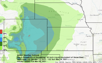
Here are probability maps of >3"of snow for each of the three days specified.
Friday afternoon to 6am Saturday
I expect the snow to begin in Denver late Friday afternoon.
6am Sunday to 6am Monday
In the City of Denver, it would appear that snow accumulations will be between 20 and 40 inches. This could be a heavy, wet snow and power failures -- if the heavier amounts materialize -- could occur in Denver and the surrounding areas. Please be prepared!!
- Get prescriptions refilled, now.
- Make sure you have plenty of critical supplies.
- Fill your car with fuel.
- Get extra cash from the ATM.
- Get if a friend or family member needs extra assistance, have them move in with you before the snow begins. It will be difficult to get to them if these amounts materialize.
As much as three feet of snow could fall in the Nebraska Panhandle. Forecasted road Interstate closures:
- I-25 in Colorado and southern Wyoming.
- I-76.
- I-70 from the Eisenhower Tunnel to central Kansas (the latter partly due to lack of hotel rooms farther west).
- I-80 from central Nebraska to Laramie.
Get any travel finished before the storm begins!
I'll have more on the storm tomorrow.


Comments
Post a Comment