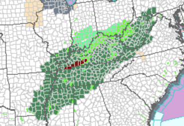
Tornado and Flood Threat Today and Tonight
As of 10:25am, here is the flood threat area we've been forecasting for the past week.
- Red is a flash flood warning. Immediate action needed if you live in a flood-prone area and -- whatever you do -- don't try to cross a flooded area by foot or by car.
- Greens are various flood watches or warnings.
UPDATED: New flash flood outlook as of 10:52am.
The area of rain now developing over Texas and Oklahoma will move east and north
over the area now experiencing flooding and will worsen the situation by tonight. And, there is a significant risk of tornadoes this afternoon and tonight in the brown area.
This includes Dallas, Sulfur Springs, Isabel, Texarkana and Arkadelphia.


Comments
Post a Comment