Posts

Showing posts from October, 2020

Hurricanes Have NOT Gotten Worse As Global Temperatures Have Warmed

Image
[I have bumped this to the top of the blog because of all of the attention this topic has received today Saturday, October 31.] -- ORIGINAL POSTING -- Two weeks ago, as Hurricane Delta was approaching the Louisiana coast, the usual suspects were trying to convince the public that hurricanes are getting worse due to global warming. That simply is not true. I'm going to run down the evidence so you can see for yourself.  The United States With a big thank you to Dr. Roger Pielke, Jr. for compiling the data, here is the record of yearly landfalling hurricanes in the United States. The trend line is slightly down.   If global warming was causing hurricanes to increase, the bars on the graph would be more or less consistently moving up along with global temperatures (orange background). Global Hurricanes There is no effect here, either. The ACE index (above) is a peer-reviewed metric that combines hurricane number and intensity. The green line is the global ACE since 1972. We can't

Weather Science Provided Outstanding Warnings of Power Failures

Image
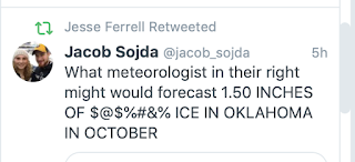
The answer is, of course, yours truly as well as other meteorologists!  This forecast was posted Sunday morning . The map was created by NWS meteorologist Steve Piltz. It is a map of electrical power failure forecast based the index that he and Sid Sperry created. I added the commentary that the index, which already called for power failures, might be conservative because leaves are still on trees. I wrote: The warning was repeated again Monday on this blog. Keep in mind this was  beyond  a weather forecast. Not only did we get the forecast of a rare major ice storm correct, we accurately forecasted the effects so people could prepare and response.  As of Saturday morning, more than 400,000 Oklahomans are still  without power.  Weather science provided plenty of warning for people to be able to mitigate the effects of this highly unusual storm.  But there was another source of major power failures this week, Hurricane Zeta. Here was an explicit forecast of power failures from Monarch

Stay Away From Railroad Tracks!!

Image
Unbelievable video. They were lucky. 

A Tornado That Sounded Like a Jet Engine

Image
I often talk about how tornadoes sound like waterfalls. And, while I have heard and read about tornadoes that sound like jet engines, I've never heard one.  This video of the 2013 Moore, Oklahoma, EF-5 tornado sounds like a jet engine. Somehow I missed it at the time and didn't run across until yesterday evening.  I suspect that the "jet engine" sound may be limited to EF-5 tornadoes. I've been close to an F-4 tornado and it sounded like a waterfall. 

More Than 7 Million People Without Power

Image
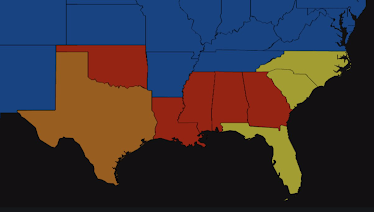
As of 6am, the combination of Hurricane Zeta and the Oklahoma-Texas ice storm have caused 2.5 million homes and businesses to lose power. It will be out for days in some regions.  The states colored in red have the highest percentage of outages.  Here is a headline from the Atlanta Journal-Constitution : Here are some of the preliminary highest peak wind gusts. 

It Will Be Even More Expensive Than Fiji Water

Image
 

Hurricane Zeta Strengthening Just Before Landfall

Image
As of 2pm, Zeta's winds are up to 105 mph and it is likely to be a Cat 2 hurricane at the time of landfall. The pink areas are under at tornado watch. See the posting immediately below for storm surge information.  This storm will produce damaging winds well inland; please prepare accordingly. 

10:35am: The Eye of Zeta Moving Toward Louisiana Coast

Image
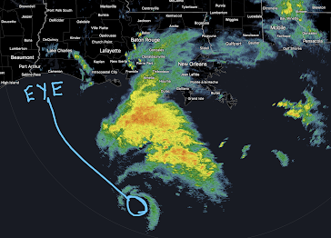
The eye of Hurricane Zeta is headed slightly east of due north in the general direction of New Orleans. Serious storm surge (below) and wind gusts to near 100 mph are likely. 

Hurricane Zeta is Strengthening

The storm is forecast to strengthen to 100 mph winds.  In addition, there will be damaging wind gusts well inland along the storm's path.  Please see the map below. 

Hurricane Warning: Louisiana, Mississippi and Alabama Coasts

Image
The red is the area of the hurricane warning which includes New Orleans. The storm is expected to move inland with sustained 80 mph winds. There will be a significant storm surge as shown below. Please plan accordingly. 

Update on Hurricane Zeta

Image
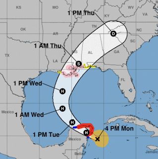
Here is the latest forecast from the National Hurricane Center.  H = hurricane. S = tropical storm (a lesser condition) D = tropical depression (weakest winds) Red = hurricane warning Pink = hurricane watch Yellow = tropical storm watch  Amber = radius of tropical storm force winds (40 mph or stronger) There is already too much hurricane suffering in Louisiana . Will Zeta will not be as strong as the previous storms this season, even a weak storm is way too much. 

Ice Storm Warning Issued

Image
 The National Weather Service issued an ice storm warning for much of the western half of Oklahoma and parts of north central Texas. It is the area in purple in the map below. I am forecasting significant icing in the southern Flint Hills counties in Kansas.  The pink areas on the map are under a winter storm warning. The blue areas are under a winter weather advisory (a lesser condition).  Below is the Sperry-Piltz Ice Accumulation Index: Below is a guide to the colors.  It is important to emphasize the conditions outlined above may be conservative because trees are still leafed out. 

Dangerous Ice Forecast For Oklahoma and Parts of Texas

Image
  For reasons that escape me, there are no official winter storm watches or warnings out for Oklahoma. So, I am going to try to inform you about the developing ice storm and its effects. Note: it is possible areas of far southern Kansas - from Medicine Lodge to Winfield to Coffeyville - could see significant icing.  Given that most trees still have their leaves, the accumulation of ice is likely to bring down power lines especially in the area in orange. My experience is that, in situations like these, power could be out for days or even a week or two. It is essential you prepare now .  This is the Sperry-Piltz Ice Index.  This index, while excellent, can be conservative when leaves are on trees.  Preparation suggestions:  Get prescriptions refilled asap.  Make provisions for infirm friends and relatives.  Visit the ATM to make sure you have adequate cash for days without power. Remember: ATMs and credit car machines may not work.  Put an app like  AccuWeather's  on your smartphone

Sunday Fun - It Would Taste Better Than Diet Pepsi

Image
 As seen on Fox Sports' coverage of the Kansas State and Kansas football game yesterday. I apologize for the lack of blog updates. Between editing the book and then the keyboard on my less than six month-old Apple Mac Book Pro failing, it has been a challenging week. Hopefully, things are getting back to normal. I invite you to follow me on Twitter @usweatherexpert. 

Great News!! President Trump Has Approved a Boost to Next-Generation Nuclear

 Next-generation nuclear is the best way to generate carbon-free reliable energy. Details are here . 

As You Ponder Your Vote....

 Please read this cogent and concise summary of the issues before us . 

Senator Harris Does Not Understand the Difference Between Greenhouse Gasses and Air and Water Pollution

Image
Oy!   As late as the 1960's air and water pollution in many parts of the nation made the air unsafe to breathe and, in some areas, the water unsafe to drink. The latter is still true in areas like Flint, Michigan. However, greenhouse gases have nothing  to do with air and water pollution. There is no reason you should fear water and air over greenhouse gasses. 

Remains of Pearl Harbor Sailor Returned

Image
The remains of Navy Fireman First Class, Rex E. Wise, were returned to his family in Braman, Oklahoma, yesterday on what would have been his 100th birthday.  Sailor Wise was one of 429 on the USS Oklahoma which was sunk at Pearl Harbor by a Japanese torpedo. The casket was on a flight to Wichita's Eisenhower National Airport and was then transferred via hearse and honor guard to Oklahoma. The full story is here .  Welcome home, Mr. Wise. And, rest in peace. 

Something Happened to My Story About the Banning of the Biden Corruption Story

Image
 It disappeared once. So, I reposted it. It has disappeared again. Instead, we see this: I don't know what is going on. Blogger, the blog publishing platform I use, is owned by Google. You can make of what what you will.  Since I do not have time to keep doing this, here are the links and we'll see if they disappear again: https://nypost.com/2020/10/14/email-reveals-how-hunter-biden-introduced-ukrainian-biz-man-to-dad/ -- and -- https://nypost.com/2020/10/14/inside-hunter-bidens-murky-history-of-business-dealings-in-china/  I highly  recommend you read the stories regardless of your politics, if nothing else as a protest to this unAmerican censorship.  Additional: More on the blocking of the story and censorship of tweets is here: https://www.thenewneo.com/2020/10/14/media-says-pay-no-attention-to-that-hunter-biden-story-behind-the-curtain/

This Evening's Wichita Sky

Image
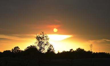
The smoke from the wildfire near Ft. Collins, Colorado, has drifted over Wichita's sky this evening. This is what the sky looked like at 6:35pm CDT from my backyard. 

Note to Readers

 I am deep into the second edit of my latest book manuscript and am not able to blog much this week. 

Vote in Person in Three Weeks

Image
Remember: "When you control the mail, you control...information" and votes!! But, there are already too many reports of irregularities when it comes to voting by mail in 2020. If you want your vote to count, I recommend you vote in person.  

No, Hurricanes Are NOT Getting More Frequent

Image
 On October 4, I posted scientific statistics  that refuted that day's  60 Minutes  and others' contention that global warming was causing stronger and more numerous hurricanes globally. In case you are interested, the long term (1900-2020) trend in United States landfalling hurricanes is also down. The statistics include Hurricane Delta, the hurricane which moved ashore in Louisiana Friday. Bottom line: Whether it is the United States or worldwide, hurricanes are not  getting worse. That said, hurricanes can be absolutely devastating to people and to society as a whole. The Weather Channel has a poignant story involving one of the victims of hurricanes Delta and Laura. 

Sunday Fun: A Quote From the Brilliant Dr. Thomas Sowell

Image
This quote is pertinent during this election season.

I Dislike Political Posts But This One is Necessary

Image
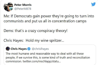
 It has been said, "whenever your enemies tell you what they are going to do, you should believe them." Keith Olberman put out this statement two days ago: “So, let us brace ourselves. The task is two-fold: the terrorist Trump must be defeated, must be destroyed, must be devoured at the ballot box, and then he, and his enablers, and his supporters, and his collaborators, and the Mike Lees and the William Barrs, and Sean Hannitys, and the Mike Pences, and the Rudy Gullianis and the Kyle Rittenhouses and the Amy Coney Barretts must be prosecuted and convicted and removed from our society while we try to rebuild it and to rebuild the world Trump has destroyed by turning it over to a virus.” Unfortunately, it doesn't stop there. ADDITION: This is a former cabinet member under President Clinton. These people cannot be allowed anywhere near the seats of power. I urge you factor these statements in when you decide how you wish to vote. 

Hurricane Delta Has Made Landfall

Image
The storm made landfall about 6pm near the town of Creole, Louisiana. 

Hurricane Delta Update 2:15pm Friday

Image
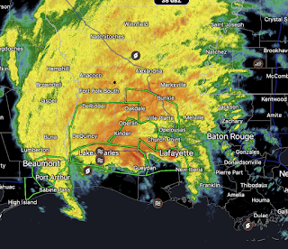
This satellite image from 2:02pm, shows the poorly-defined eye of the storm (there is no radar echo over most of the southwest half of the eye) moving north northeast. It will make landfall this afternoon between Camera and Intracoastal City, Louisiana.  At 2pm, Delta has maximum winds of 105 mph and a central pressure of 966 millibars. That makes it a category 2 storm in wind intensity. However, it will be a serious storm in terms of storm surge. There are already reports of water 4' above sea level along the Louisiana coast. The chances of tornadoes will increase the next few hours with a significant risk in the yellow area.

Hurricane Delta, 9:25am Friday

Image
The storm continues to move in the direction of a landfall along the Louisiana coast south of Lake Charles. The peak gusts in the hurricane are around 120 mph but I believe they will weaken a bit before landfall. While a serious storm, it will not be as destructive as Laura. 

Re-Strengthening Hurricane Delta, 4:10pm

Image
10pm Update: As expected, the peak wind increased to 120 mph. I still believe the peak gusts will be around 105-110 mph at landfall. The rest of the forecast is unchanged. --- original posting --- 5 Re-intensifying Hurricane Delta at 3:46pm.   While the winds have increased a bit at ocean level (they are 115 mph); the Hurricane Hunters are now measuring peak winds of 138 mph winds aloft. Those stronger winds, along with some lightning near the eye, might be a sign further intensification is possible.  At landfall winds of around 105-110 mph are likely. This would be sufficient to cause significant damage but would be less than the wind speeds of Hurricane Laura. Major Storm Surge is forecasted. Here are the times of arrival of winds 40 mph or stronger. Even though utility crews have not finished the job of fixing the grid after Laura's visit, they are going to be highly challenged again. Safety measures should be rushed  to completion.  Safety Recommendations With COVID Factored In

Hurricane Delta Update: 10:10am Thursday

Image
Hurricane Warning for Louisiana Coast for Landfall Friday Storm Surge Warning for Louisiana, Mississippi and Alabama Coasts For the first time (10:45a), Delta has a well-defined eye.  Pressure has dropped 4 additional millibars since 10am.  Here is the latest on Hurricane Delta which is now moving toward the Louisiana coast. The storm is slowly restrengthening as it moves north. Winds are 105 mph and the central pressure is 968 millibars. Forecast Path: The wind speed at landfall is forecasted to be 105 mph .  Storm Surge Warning There is a risk of tornadoes (the brown area has the higher risk) from 7am Friday to 7am Saturday in the areas shaded. There is a serious risk of inland flooding. The dot near Alexandria, LA is a forecast of ten inches of rain. Safety Recommendations With COVID Factored In: Make a hotel/motel reservation well inland. There is no point to getting on the road and finding everything already sold out.  Be sure and cancel if you do not need the room.  In this case,