Posts

Showing posts from April, 2020

Locations of Category 5 Hurricane Landfalls

Image
click to enlarge Monday, I wrote about F-5 tornadoes. Today, with hurricane season a month away, here is a map of the location of landfalls of Category 5 hurricanes. I found it interesting. 

A Review of Yesterday's Forecast

Image
I thought it was important, after the strongly-worded forecasts of yesterday that I review them.  On the left is a map of storm reports. Additional reports will be added today but they are enough upon which to base an assessment of the forecast. Greens are large hail. Blues are winds. On the right was the forecast. The geography aspect of the forecast was quire good. It gets an A. The intensify aspect was overdone. There were many reports in the 60 to 65 mph range. Those caused some scattered power outages and other damage. But, wind force (the power in the wind) is a square function. So, the 75-85 mph wind gusts I was expecting would have caused much more damage to the grid. I give myself a C-. Thank you for reading.

Free Respirator With Every Purchase of a Toaster!!

Image
Please read from the bottom, up. Pete Gaynor is the head of FEMA. Where's Art Fern when we need him? He'd move the merchandise!

More on the Stunning Success of Weather Science

Image
The National Hurricane Center has finalized its report on the catastrophic Hurricane Dorian. As a result, here is a ranking of the most intense hurricanes to strike the Atlantic Ocean Basin (Atlantic, Caribbean, Gulf of Mexico). The chart is below. You will, I'm sure, have to click on it to make it fully legible. One-hundred sixty knots = 185 mph sustained winds. As I was researching this post, I went back to look up the number of deaths associated with Dorian. I was flummoxed to learn, according to Wikipedia, 70 were killed. The second strongest hurricane in history in the Atlantic Basin, $5 billion in damage, yet just 70 confirmed deaths (there are a number still missing). While each of those is a terrible tragedy for the families involved, that number is so low as to take your breath away. Original estimates were in excess of 2,000. While I am certain there were other factors involved, this is another "miracle" of weather science. Had this storm struck without war

F-5 Tornadoes: Ranking the Highest of the High

Image
Violent Oklahoma Tornado. Courtesy of Dick McGowan I wish to direct your attention to a fascinating list ranking the intensity of the 59 tornadoes since 1950 that have been rated F-5. You can access the article, here . The reasoning is very sound and the timing is excellent. Yesterday was the anniversary of the Wichita-Andover Tornado (5th strongest tornado since 1950). Today is the 9th anniversary of two of the top three. The #3-ranked tornado by intensity was the Hackleburg, Alabama, Tornado which occurred on this date in 2011. #2 was the Jarrell, Texas, tornado of 1997. #1 was the incredible Smithville, Mississippi, tornado of this date in 2011.  Four tornadoes that have played a role in my life (Ruskin Heights, Udall, Andover, and Greensburg) are all ranked as average or stronger than average F-5's. You can read more about those in my book, Warnings: The True Story of How Science Tamed the Weather .  The Joplin Tornado is ranked 21st and it is the topic of my

Scientific Analysis: Lockdowns Are Not the Way to Handle Coronavirus

Image
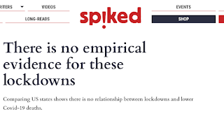
Spiked  published an article April 22 a scientific and statistical analysis of the lockdowns versus social distancing. It didn't come to my attention until yesterday. The money paragraph: This piece tackles that question. As a professional political scientist, I have analysed data from the  Worldometers Coronavirus project , along with information about the population, population density, median income, median age and diversity of each US state, to determine whether states that have adopted lockdowns or ‘shelter in place’ orders experience fewer Covid-19 cases and deaths than those which pursue a social-distancing strategy without a formal lockdown. I then briefly extend this analysis to compare countries. In short, I do not find that lockdowns are a more effective way of handling coronavirus than well-done social-distancing measures.  [emphasis mine] The statistical analysis looks solid and I urge you to read the article for yourself and form your own conclusions. As to m

Thank You

Image
Photo of the tornado approaching homes in Andover The time is incorrect. The tornado hit around 6:45pm Today is the anniversary of a critical event in the history of south central Kansas -- the Wichita-Andover Tornado (and, the other less tragic tornadoes of that day). It was April 26, 1991. I wish to thank everyone who contacted me today. I was just doing my job. The important thing was that more than 70 lives were saved.

Sunday Fun: Fungi Boat

Image
You'll have to excuse me if I do not  think "fungi boats" is the solution to global warming.

If You Wish to See Michael Moore's Movie That Strongly Criticizes Green Energy...

Image
...you may need to act fast. I understand it is being taken down due to the furious reaction from Big Climate. The movie strongly  criticizes 'green' energy. Here is a link that was working as of 8:55am CDT. My review of the movie, posted Tuesday, is here . As I say in my review, I never thought I would agree with Michael Moore on anything.

New Yorkers Seem to Have An Odd Perception of "Flocking"

Image
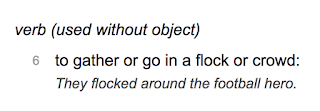
From Dictionary.com, the definition of "flock." From the New York Post : There were nine photos to illustrate people "flocking" (crowding) the beach but none of them show that. New Yorkers appear to have self-hypnotized themselves into thinking the rest of the nation are a bunch of irresponsible fools when the evidence -- right before their eyes -- demonstrates the opposite. The media, based in NYC, suffers those same self-delusions as does their sister media in the District of Columbia. In NYC of the west, here is a photo of the beach in Southern California today along with an urgent plea: Look closely at the photo: Most everyone is maintaining social distancing. Plus, they are outdoors. With any kind of distancing, there is effectively zero chance of catching the virus . I agree with the Washington Post. We should wise up and think for ourselves. The same issue of the New York Post  contains this nugget. Does anyone realize the implications

This Week's Rainfall in the Winter Wheat Belt

Image
While winter wheat is grown in other areas, this is the region of the greatest concentration in the United States. Rainfalls fell in generous amounts several different times so there was no major flooding. For those that are not aware, most of the winter wheat in this region is planted in September and harvested in May and June.

I Wish I Had Thought to Frame the Shutdown Issue In This Way

Image
While they started out with the best of intentions, the COVID-19 shutdown has degenerated into a non-scientific mess. While it is still essential that people -- especially people over 60 and with compromised immune systems -- take isolation precautions against coronavirus,  the near-total shutdown of American commerce needs to be reversed as quickly as possible. If you need more evidence, please read this piece from an MD . Dennis Prager puts things in perspective in this manner: Imagine that Georgia and North Carolina -- two contiguous states that, like the New York metro area, have a combined total of 21 million people -- had 18,690 COVID-19 deaths, while metro New York had 858 deaths (the number of deaths in North Carolina and Georgia combined). Do you think the New York metro area would close its schools, stores, restaurants and small businesses? Would every citizen of the New York area, with the few exceptions of those engaged in absolutely necessary work, be locked in t

Some Comments on Tornado Season 2020, So Far

Image
The map below is of the reported tornadoes for this year as of 7am this morning. You'll notice something highly unusual: California (1) and New Mexico (3) have more tornadoes than Kansas (0) or Nebraska (0). In tornadoes have been rather sparse, compared to average, north of Interstate 70. What is tragic about this year is that we are up to 75 fatalities. This is, by far, the worst since the awful year of 2011. Ted Fujita wrote a paper around 1970 (I don't remember the exact year) noting that major tornado events (he want back to 1916) tended to cluster the the Great Plains, then the Midwest, then Dixie Tornado Alley. Certainly the last two years have seen far about normal numbers of tornadoes in the South. For the foreseeable future (in meteorology, about seven days), most of the tornadoes will be in the South.

An Enhanced Tornado Risk Again Today

Image
The 2020 tornado season has been especially active and, based on the SPC forecast, today is no exception.  The Ark-La-Tex region has an enhanced risk of tornadoes. This includes Idabel, Arkadelphia, Shreveport and Tyler. The brown area has a significant risk and it includes Tulsa, Little Rock and Lufkin.  Please keep up on the weather in these areas today. 

The Insanity of the Mainstream Media

Image
These two headlines in the last 24 hours illustrate the innumerate and ignorant mainstream media from which we suffer. Look at the photo. How many will catch COVID-19 in this manner? None. Literally none of the people on this beach will catch COVID-19. Per my board-certified immunologist: I think being outside with someone is certainly safer than inside. The droplets and aerosols would disperse more quickly and widely. I guess you could walk thru someone's vapor cloud, or have it blown into you if downwind. Ambient factors such as UV light from the sun, temperature, humidity, wind, would all make a difference.  When you combine the fact that people are staying well separated, it is an absolutely stupid illustration. Does the NYT not understand the very basics of how any virus is spread?! It is incredible they are still relying on the completely discredited epidemiology models . They have been shown to have no skill at forecasting even two weeks in the future. Ahhh, NY

Thunderstorm Approaching Wichita

Image
At 7:10pm, looking WNW from my home, I took this photo. There is nothing like the Kansas Sky in springtime. Yes, that is cloud-to-ground lightning at left. Enjoy.

The Increase in Storm Forecast Accuracy

Image
One of at least 20 similar comments. They were part of a thread that began a week ago, today.  You might have seen the controversy that began a week ago today on Twitter and other social media pertaining to weather forecast accuracy. I understand that some forecasts bust . And, if you have an outdoor event and the forecast is wrong, it can be extremely frustrating. I get it. But, the idea that weather forecasts are usually wrong is incorrect. And, the progress weather science has made in warning of storms is stunning. Because of that on-line discussion, I thought the forecasts of flash flooding and the violent, long-track tornado of this past Sunday in the South would make a good example of the progress weather science has made (hat tip, Greg Carbin). Rainfall Amounts Below are NWS  forecast  rainfall amounts from 7am Sunday through 7am Monday. The forecast was published at 3:41am Sunday morning. Because of the already wet ground, the forecast rainfall, up to 4" in A

Extreme Video Yesterday's of Madill Tornado

Image
I am of two minds when it comes to extreme chaser videos. I don't want to encourage being close to tornadoes. I'm posting this video because, 1) it shows how a tornado causes its destruction and, 2) it shows the visible funnel does not have to be in contact with the ground for a tornado to cause major damage. Pecos Hank, the storm chaser who took this video, is amazingly talented as this video demonstrates.

Today's Tornado Risk: Southeast

Image
There is an enhanced risk of strong tornadoes in the hatched yellow area. This extends from Mobile to Savannah and Jacksonville. The brown area has a significant risk which extends from Nashville on the north to Orlando and Tampa on the south. Please keep up on the weather in these areas today.

Today's Tornado Reports

Image
This map indicates the tornado reports (red) and wind damage (blue) reports as of 11:25pm Wednesday. There will be many, many more tornado reports added when field surveys are completed. The amazing thing is the purple arrow. It represents a supercell thunderstorm that developed near College Station, Texas, and disorganized in far southwest Mississippi. Many reports of damage from the tornadoes it spawned. We know of one fatality in Texas and at least two in Oklahoma.

Tornado Watch: North Texas and Southern Oklahoma

Image
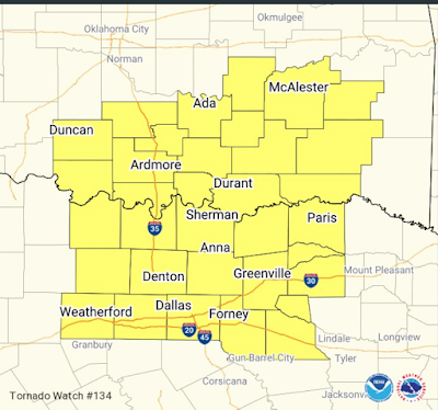
The tornado watch is in effect until 9pm The watch includes Dallas and Ft. Worth as well as northern portions of the Metroplex, such as Denton. It is my opinion that strong tornadoes will occur in the outlined area. Giant hail is also possible. Please keep up on the weather the rest of this afternoon and evening.

Serious Tornado Risk This Afternoon and This Evening

Image
I'm very concerned about violent tornadoes in the outlined area. I believe supercell thunderstorms will develop during the early afternoon and move toward the eastern part of the outline by evening. Now is a good time to prepare. Make sure you have at least two sources for receiving a warning in addition to sirens and television (you can lose power before television can get the warning to you). Please test your weather radio. Set up a " tornado alarm ." The tornado alarm will alert you wherever you are and will minimize the false alarms. In addition,  a tornado watch has been issued for south Texas and west central Louisiana. Note there is a "moderate" chance of strong tornadoes. This does include the northern suburbs of Houston.