Posts

Showing posts from December, 2019

Happy New Year!

I hope 2020 is the best year ever for all. 

Big Climate: Always Certain. Always Wrong.

Image
February 21, 2004, the London Guardian. Forecast sinks. Cities fine. None  of the global warming alarmists' apocalyptic forecasts have come to pass. The global warming models continue to run too warm. While global warming is a problem , it is not catastrophic. My 2020 gift is: Stop worrying! The earth is doing just fine. 

Snow Continues in the Central and Northern Plains

Image
Blizzard conditions continue in southeast North Dakota and parts of far NW Minnesota.

Sunday Fun: Criminal Mastermind

Image
Details, if you wish to read them, are here . Makes you wonder if we need a better class of criminals. 

Tornado Watch: Ozarks Until 10pm

Image

Significant Tornado Risk: Ozarks

Image
The NWS SPC is now forecasting a significant risk of a tornado or two in the Ozarks region. This includes: Fayetteville, Joplin and Branson. Please keep up on the weather that area the rest of the day as any tornado will be fast moving and may develop quickly.

"Tsunami City"

Image
Crescent City, California, is uniquely vulnerable to tsunamis. They are trying to attract tourists by marketing that fact in a manner somewhat akin to storm chasers visiting tornado alley. The Los Angeles Times  has the story.

8:50am Friday Winter Storm Update

Image
Update at 10:50am A mix of freezing rain, sleet and snow is developing in the outlined area. This will affect I-70 by afternoon along with U.S. 400. Please follow Twitter for my updates @usweatherexpert.  --- Original Posting 8:47am --- Above is storm total snowfall.  Pink = winter storm warning.  Purple = winter weather advisory. Gray/blue = winter weather watch. 

Essential Reading: U.S. Energy

Image
This is just one of the fascinating sets of facts in the new Axios article about U.S. energy. It is not at all what was predicted (at least predicted by the "consensus") in 2010. I urge you to read the brief, but highly informative, article.

UPDATE: 6:15pm Thursday Travel Update

Image
Here is a map of winter weather and other advisories: Blue-gray = winter storm watch. Pink = winter storm warning. Purple = winter weather advisory (lesser condition). Free = flood advisory. And, here is a rough  second-guess of how much snow may fall with this next weather system. ADDITION: Here is the AccuWeather snow amount forecast along with storm timing. Note: light snow will fall farther south than covered on the AW chart. 

From "Dave Barry's 2019 in Review"...

Conspiracy theories swirl in the wake of the death of  millionaire pedophile Jeffrey Epstein , who committed suicide in a New York City federal prison cell despite supposedly being under the close supervision of an NFL officiating crew. The rest of his hilarious piece is here . Also: SEPTEMBER ...begins with President Trump facing a major crisis involving the crucial issue of  whether Alabama was, or was not, ever actually threatened by Hurricane Dorian . The crisis erupts on September 1, when, with Dorian moving toward the U.S. mainland, the president tweets that Alabama is among the states “most likely be hit (much) harder than anticipated.” Minutes later the National Weather Service responds with a statement that “Alabama will NOT see any impacts from #Dorian.” At this point the president acknowledges that he made a minor mistake, thus laying the issue to rest and freeing everyone to focus on more important matters. Ha ha! That would never happen. Donald Trump did no

Is This The World In Which We Want to Live??

Image

Preliminary Weekend Travel Outlook

Image
A very preliminary forecast of snowfall amounts for the weekend storm. 

Merry Christmas!!

Image
We wish you and yours a  wonderful, joyous Christmas. As we look out this amazing universe and our wonderful home, we should be grateful each day for the gift of Faith and pray for those who have not yet achieved it. Joy to the World! And, here is a little Christmas humor. In case you are not a fan of The Big Bang Theory,  Sheldon is both the chief nerd and a huge Star Trek  fan. I think the rest speaks for itself.  From the greatest alto voice of the 20th Century. Her performance of The Christmas Song  is amazing.  For some Christmas smiles, here is ultra nerd and ultra Star Trek  fan Sheldon Cooper receiving a Christmas gift from their sweet neighbor, Penny.  And, finally, Catholics will like this one .

Weather Forecasting Explained

Image
Courtesy: The Weather Channel No kidding. This is how meteorology is taught because this is how the atmosphere works. A meteorology education is solid equations, math and physics. On this Christmas Eve, meteorology students around the world are rubbing their eyes trying to deal with the eyestrain all of these equations cause.

Thank You, President Obama

While President Obama and I agree about almost nothing politically, I think he would be a fine friend and next door neighbor. I like what he says here.

Being a Coroner in Florida Must Be Quite a Challenge

Image

An Insightful Tweet

Image
On the same theme as the posting below.  While I would not characterize the MSM as "savvy" about civil liberties, I agree with the rest. 

A Correction About the Joplin Tornado

Around the internet there are several lists of "worst" tornadoes of the decade we are wrapping up. I have seen comments  on one list to the effect the Joplin Tornado's death toll (an incredible horror of 161) could have been "much worse" if the high school graduation had not ended before the tornado destroyed the school. This is factually incorrect. Because of the huge crowd projected, the graduation ceremony had been moved to Missouri Southern University which was outside of the path of the tornado. The graduation ceremony's timing had no appreciable effect on the death toll. That story, and the entire story of the Joplin Tornado, is told here .

Washington Post's Article on the Business of Weather

Image
[Update: December 20] I am delighted to report that Mary Glackin, incoming President of the American Meteorological Society, and Dr. Joel Myers, founder of AccuWeather, have published a joint essay to refute the Washington Post's  unfortunate article discussed below. Among the points they make: A  recent  Washington Post  article  mistakenly conflated warning services provided by NOAA with custom warning services provided to private clients. In fact, with example after example, there is no doubt private companies, such as AccuWeather, which has received many AMS accolades for its warnings and expertise, can and do provide valuable warnings and services to private clients. It was unfortunate that a comment said on the fly was taken out of context. Both AccuWeather and AMS view the incident in this light and are continuing to build on their shared history of partnership. AccuWeather works closely with NOAA and NWS to make sure communities and businesses have the best informat

Astonishing: China Supplies 80% of Our Generic Drugs

I had no idea that China has a chokehold over our drug supply. Please read this article . Here is an excerpt: The concentration of penicillin and other antibiotic production in a single country poses risks to our nation’s health security. Take the case of an antibiotic to treat life-threatening sepsis. One factory in China exploded and triggered a shortage in the U.S. and around the world.   Chemotherapy to treat cancer isn’t immune to China’s cartel strategy. The FDA had to ban chemotherapy products from a plant in China that is a dominant global supplier. The agency had received many reports from commercial customers about products that didn’t have the right amount of active ingredient, the part of a medicine that provides therapeutic value. Too much can be overkill, too little can render it ineffective. Hospitals had to ration chemotherapies because of a shortage.    Other essential medicines are ensnared in China’s cartels. A physician at a Boston hospital was quoted in the m

Mariah Carey: Yet Another Global Warming Hypocrite

Image
Do any of these people actually believe what they are saying? Another global warming hypocrite who believes "we" (you and I) have to fix global warming... ...while she makes the situation worse  by flying by private jet!

The Late Gary Shore

Image
My friend, Gary Shore, passed away at far too young an age in 2008. As this and other news stories noted, he began his career with me in Wichita in 1977. At the time, I was asked if I had any photos of him when he first started. I replied that if I ever found one, I would post it. Ran across one today and here it is for anyone who would like to see it. Gary was passionate about weather and about saving lives. We all miss him.

Why I Am So Critical of Climate 'Science'?

Image
Let's begin by re-stating information about which we can be confident: The earth is warmer than it was sixty years ago. Mostly unreported is the warmer climate has, on balance, been great for humanity.  Humans affect the climate in many ways.  Continued increases in greenhouse gases, other factors equal,  will promote additional warming. However, many processes affect climate. CO2 concentration is absolutely not a  thermostat for earth's temperature, especially since ocean heat content is more important than atmospheric heat content.  We know far less about the processes governing earth's climate than most climate practitioners would have you believe. In no way is the science settled. For example, we don't even know the optimum temperature of the earth's atmosphere.  We have almost no ability to meaningfully forecast future climate. We can't even make climate forecasts for a year or two ahead let alone decades ahead.  "Consensus" has no role

With Just Over a Week Until Christmas,

Image
...a hard cover book is a great gift. Learn about how meteorologists save thousands of lives a year during tornado outbreaks like today's. You can read the excellent reviews and purchase a copy, here .

Louisiana: This is Very Dangerous

Image
There is a high risk of violent tornadoes in the purple hatched area. This includes Alexandria and Ft. Polk. Please closely monitor the weather and be prepared to take shelter at a moment's notice. Safety suggestions immediately below. 

High Risk of Violent Tornadoes

Image
The NWS SPC has ratcheted up the risk of violent tornadoes. Please make sure your family and friends are aware! The brown area is a significant risk of tornadoes. The yellow is what I would call an enhanced risk and the red is a high risk. The hatching is where they are forecasting violent  tornadoes. In addition to alerting your family and friends, make sure you have at least two independent source of local storm warnings. For example, a weather radio and the AccuWeather App with location services enabled. Sirens don't count. Plug in and charge phones and computers before thunderstorms approach. Lightning could cause a power surge that damages their electronics. Insure your shelter area is in good shape with a couple of bottles of water. Make sure you wear shoes into your shelter and take your warning information system into the shelter with you. UPDATE: 10:48am. The first tornado watch of the day. Note this includes far southeast Texas. 

Increasing Risk of Tornadoes

Image
There is an increasing chance of tornadoes in the red hatched area. A strong tornado is possible. Please monitor the weather in this region the through early evening.

9am Radar Update

Image

Significant Tornado Risk Monday and Monday Night

Image
The brown shaded area has a significant tornado risk. The yellow area from Alexandria and Monroe to Jackson and Natchez has an enhanced  risk.  Please keep up on the weather in this region later today.

9pm Radar Update

Image
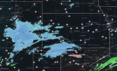
The second area of snow is now growing rapidly in size and moving east northeast. Late data this evening indicates there is a chance of thunder-snow in south central Kansas or thunder-sleet in north central Oklahoma during the night. If so, a few areas could somewhat more accumulation than shown below in the 2:55pm update. However, it is impossible to make that forecast before thunder-snow develops. Note: Last update of the night.

6:05pm Radar

Image
Below is the forecast for additional snow starting now. As you can see, there are two rounds of snow with this storm.

2:55pm UPDATE: Forecast for Additional Snow

Image
click to enlarge  Above is my forecast for additional  snowfall . This forecast starts at 6pm CST this evening and extends until 6am Tuesday. Note: That is the duration of the forecast; not the duration of the snow. For example, the snow in the Wichita area is not expected to redevelop until between midnight and 6am Monday Below is a summary of National Weather Service "headlines" currently in effect. The colors mean: Pink, winter storm warning. Green, flood watch. Purple, winter weather advisory. Brown, high wind.  And, here is the regional radar as of 2:45pm. 

Note: Risk of Tornadoes on Monday

Image
Especially if you live in the red area, monitor local weather information Monday and Monday night.

Winter Storm UPDATE, 11:40 CST Sunday

Image
I have not updated the 9:40pm Saturday forecast because it still looks pretty good. Here is the radar at 11:35am Sunday: 11:35am Sunday ________  In northeast Wichita, the Sunday noon weather is 28°F with light freezing drizzle. There are accidents on bridges and freeways throughout the city, some victims in critical condition. _______ Based on this evening's data: if anything snowfall amounts in Missouri may be a touch low. I've added an area of light accumulating snow in the High Plains. Almost forgot: The 4-8" area goes as far south as I-70 in Missouri.  Total Snow Sunday thru Monday Night Update = area in the Panhandles and SW Kansas  Amounts of Freezing Drizzle or Freezing Rain A Wider View of the Storm

Sunday Fun: Sounds About Right

Image

"Richard Jewell"

Image
I went into the theatre yesterday with moderate-to-high expectations for Richard Jewell.  It exceeded them in every way. The actor that played Richard, Paul Walter Hauser, absolutely, positively deserves the Oscar for best actor. What a performance! Five stars. BTW: