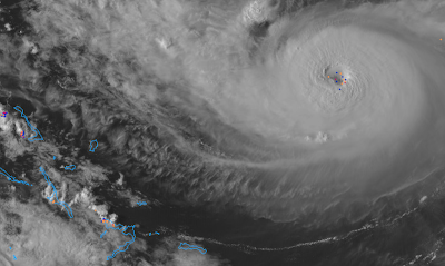
Hurricane Dorian: 5:10pm EDT, Friday
 |
| 4:59p image of Dorian. Dots are lightning bolts. Lightning near the eye of a hurricane is bad as it is a sign the storm is strengthening. |
Hurricane warnings are out for much of the Bahamas (red) Islands. The amber is the area now experiencing tropical storm-force winds and the brown is the area experiencing hurricane-force winds. The respective areas will increase a little in size as the storm intensifies. It is forecast to be a 140 mph storm, with gusts to 155 mph, at landfall. Wow.
This storm will produce a deadly storm surge as well as highly destructive winds.
Extensive flooding is likely. A least a few tornadoes are possible.
You'll find my safety recommendations here. While you ponder those, please consider the thoughts below from Florida less than one year ago.


Comments
Post a Comment