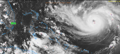
Hurricane Dorian, 2:37p Friday Update
Dorian is continuing to intensify. It is now a Cat. 3 storm with sustained 115 mph winds and pressure down to 970 millibars. The dots south of the eye are lightning which indicates the storm will continue to intensify, perhaps rapidly.
The models today have shown a bit of a northward jog. If you'll recall, my landfall forecast is between Daytona Beach and Miami. I still think that is good but it is important to emphasize that landfall may occur anywhere in that zone. It is also important to empathize that the damaging winds are a zone (see magenta colors 2 postings down), not a point. So, damaging winds and storm surge may occur outside of the point of landfall.
The models today have shown a bit of a northward jog. If you'll recall, my landfall forecast is between Daytona Beach and Miami. I still think that is good but it is important to emphasize that landfall may occur anywhere in that zone. It is also important to empathize that the damaging winds are a zone (see magenta colors 2 postings down), not a point. So, damaging winds and storm surge may occur outside of the point of landfall.


Comments
Post a Comment