Posts

Showing posts from August, 2019

Hurricane Dorian, 10a Saturday

Image
The computer models which, beyond 24 hours, are absolutely necessary for hurricane forecasting, have now backed off from a Florida landfall. Instead, they have Dorian paralleling the coast bringing high surf and high winds. Right now, I don't know where -- or even if -- the eye will make landfall. I think we are going to have to wait for another model run to figure this out.

Two Words: They Won't

Image

Hurricane Dorian: 5:10pm EDT, Friday

Image
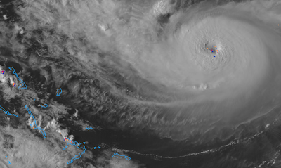
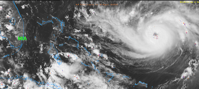
4:59p image of Dorian. Dots are lightning bolts. Lightning near the eye of a hurricane is bad as it is a sign the storm is strengthening.  Here is the National Hurricane Center's new forecast along with my ongoing forecast (orange lines) of the path of the eye of Hurricane Dorian. Hurricane warnings are out for much of the Bahamas (red) Islands. The amber is the area now experiencing tropical storm-force winds and the brown is the area experiencing hurricane-force winds. The respective areas will increase a little in size as the storm intensifies. It is forecast to be a 140 mph storm, with gusts to 155 mph, at landfall. Wow. This storm will produce a deadly storm surge as well as highly destructive winds. Extensive flooding is likely. A least a few tornadoes are possible. You'll find my safety recommendations here . While you ponder those, please consider the thoughts below from Florida less than one year ago.

"But, It Was 'Clear Air Turbulence', There Was No Way to Avoid It"...

Image
likely said the crew of the idiots who flew across the severe thunderstorm complex in northern Oklahoma yesterday evening Friday morning. I wouldn't want to have had that conversation with the company's chief pilot. Amazing how every other pilot figured out that flying through it would be a very bad idea.  This is yet another case of what I call aeronautical malpractice . Addition, Friday, Sept. 6:  I received some pushback on this post by a person in Washington, DC, who said there likely wasn't turbulence in this area. The above is the spectrum width data from the WSR-88D located at Twin Lakes, Oklahoma. Higher values of spectrum width are associated with turbulence (something I have, unfortunately, personally experienced). Orange is moderate to severe turbulence and reds are severe or even extreme turbulence. The plane is flying in a dangerous location. 

Golden Oldie Blog Post: The [conservative] $700 Million Weather Forecast

Image
Given all of the angst pertaining to the eventual path of Hurricane Dorian, I would like to repeat a posting from this blog in November, 2010, pertaining to the forecast of Hurricane Earl. Title? The $700 Million Weather Forecas t . And, if you have ever wondered how meteorologists make these life-saving forecasts, I have written a book on that subject. You can learn more about it here ... or, for the ebook, here .

Hurricane Dorian, 2:37p Friday Update

Image
Dorian is continuing to intensify. It is now a Cat. 3 storm with sustained 115 mph winds and pressure down to 970 millibars. The dots south of the eye are lightning which indicates the storm will continue to intensify, perhaps rapidly. The models today have shown a bit of a northward jog. If you'll recall, my landfall forecast is between Daytona Beach and Miami. I still think that is good but it is important to emphasize that landfall may occur anywhere  in that zone. It is also important to empathize that the damaging winds are a zone (see magenta colors 2 postings down), not a point. So, damaging winds and storm surge may occur outside of the point of landfall.

Two Things Worth Passing Along

Image
1. Walgreens is currently running a promotion (popped up on my Twitter feed this morning) pertaining to teachers having to spend, on average, $430/yr on their classrooms. That's well and good and I'm sure we all want to assist teachers. However, has it occurred to you how much this hurricane is costing meteorologists and emergency managers? I know of meteorologists who had plans for the Labor Day weekend. They are having to forfeit non-refundable air fares and hotel deposits or even the cost of all of the room-nights they had booked. Plus, while they are at their offices covering the storm they are having to leave their families. Where is the publicity and empathy about them? 2.  I had not planned to be writing stories on the blog this weekend because I had family plans. So, it was extremely discouraging as I was watching Fox News on a hotel lounge television saying, "hurricanes are unpredictable and no one knows exactly where this one will go." Unpredictable...

Hurricane Dorian: 9:35a Friday

Image
Dorian's winds are now 110 mph with a central barometric pressure of 972 millibars. Additional strengthening -- to Cat 4 wind speeds -- is forecast before landfall. A vicious storm surge is likely at landfall. When combined with higher than normal tides, it will likely be a devastating storm near where the center crosses the coast when the eye arrives Monday. As to the location of landfall, my forecast hasn't changed since yesterday: between Miami and Daytona Beach.  If you have friends/family in the threatened area, please pass this along to them. Here are the times by which you should have your preparations complete. click to enlarge Below is a rough  idea of the placement of the winds. Keep in mind this could shift north or south. Coastal buildings would be devastated due to the combination of winds and storm surge. The above is the latest forecast from the ECMWF model. If this were to be a perfect forecast, it would be one of, if not the costliest, disast...

Kansas Supercell Timelapse

Image
This is a time-lapse of a supercell thunderstorm that produced a brief tornado near Alta Vista, Kansas., August 15. The storm occurred in the Flint Hills region of our state. Few people live there. Because of its nourishing grass, it is the largest cattle grazing area of the world. A supercell is a rotating thunderstorm (you can see the rotation in the time-lapse). It is the only type of storm that can produce the rare super tornadoes (F-5's) and giant hail.

Hurricane Dorian Update: 9:20pm Thursday

Image
I wanted to provide a complete update on Dorian  so you could hit the ground running in the morning.  Unfortunately, the storm is strengthening this evening. Pressure has dropped to 973 mb (it was 986 at 5pm) and it appears winds are now up to 95 mph (up from 85 mph at 5pm).  At 9pm, it is looking more organized on satellite than it did earlier in the day. So, the Hurricane Center's forecast of a Cat 4 hurricane striking Florida looks like it will be correct. As to where, here is their latest forecast. Here is their 5pm (latest) forecast (white). I have modified my landfall location forecast (red bars) slightly. The southern side remains at Miami. The northern edge has been moved south from St. Augustine to Daytona Beach. M = major hurricane. Tornadoes and severe flooding are also likely in Florida with the storm. The above is the NWS's rainfall amount forecast. However, I believe it is quite conservative. Some areas will receive 15" or more. I belie...

Hurricane Dorian, 5:50pm Thursday

Image
No reason for any updates as to my forecast (scroll down) or advice. Here is an updated rainfall forecast for the next seven days. Significant to major flooding is likely in Florida. The NWS is doing special balloon launches and aircraft recon at the present time and that data will be put into the evening models. Hopefully, tomorrow morning, we will have higher confidence in our forecasts.

11:30a Thursday, Hurricane Dorian

Image
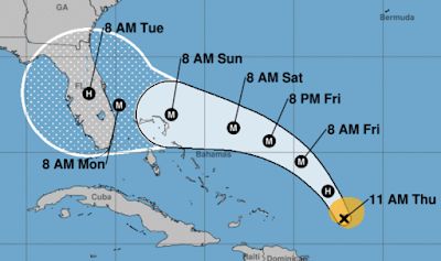
Here is the National Hurricane Center's latest forecast. M = Major Hurricane. The storm is forecast by NHC to have 130 mph sustained winds, with gusts to 150 mph, at landfall. My forecast for landfall, between Miami and St. Augustine, continues unchanged. It should be noted the two most reliable computer models forecast paths south of the NHC forecast. There is even a possibility the storm could reach Category 4 intensity. Here is the time by which you should have your preparations completed. Tornadoes and flooding are  likely.  The forecast total rainfall from now until 8am Thursday. Scroll down for my preparation recommendations. 

Hurricane Dorian: FYI...

Image
I was asked what the difference was between my forecast and the NHC forecast. The NHC forecast is within the thick white line. My forecast is between the red lines. If I lived between the red lines, I would be making preparations for Hurricane Dorian. If I were between the red and white lines, I would closely monitor the situation. What to do now? Given it is a holiday weekend, you may wish to consider getting out of Dodge before an official evacuation starts and roads become jammed. Close down the home (turn off electricity, water, board up windows, etc.) and go somewhere like Atlanta well out of harm's way. Make a reservation now. Let Mother Nature do her thing without you and your family harm's way.  If that is impractical, then I urge you to consider the following: If you want a generator,  have an electrician install it. If you decide on a portable generator, make sure to place it outside well away from any air intakes.  An automobile power inverte...

Hurricane Dorian: Thursday, 8:25am

Dorian weakened significantly during the night based on both satellite and Hurricane Hunter recon data. Unfortunately, it is restrengthening based on satellite data. The NHC forecast hasn't changed significantly. Mine hasn't, either (landfall of the eye between St. Augustine and Miami). Please scroll down for more information.

An Outstanding Article About the State of Climate Discussion

This is a well-balanced article . Highly recommended. And, as an aside, I don't receive any money from oil companies. That stated, I am completely willing to accept huge checks from either side!!

10:50pm Wednesday, Hurricane Dorian

No updates to the information below. Please scroll down for the latest. I will update Thursday morning. Good night.

[Updated] Do Airline Executives Stay Up Nights Thinking Up Terrible Ideas to Inflict on Their Customers?

Image
The latest is from American Airlines. The story is here . After I fired United in 2014 (richly deserved), American has been my go-to airline. However, the last few flights have been less than stellar. So, when I go to the National Weather Association's Annual Meeting in Huntsville next month, I chose to try Delta. Given this latest nonsense from American, I'm glad I did. American Airlines: instead of spending money on another intrusion into your customers' privacy, how about spending those funds upgrading your customer service? UPDATE: 7:30PM FRIDAY. Looks like I spoke too soon about Delta. I already have my tickets purchased. But, looks like I will be, on principle, flying even less going forward.

Hurricane Dorian Update: Wednesday, 5pm EDT

Image
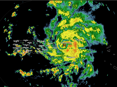
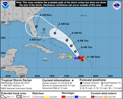
All of the reliable computer models place landfall of what is forecast to be major hurricane Dorian on the central or south Atlantic coast of Florida during the latter half of the Labor Day weekend.  It is still too soon to state exactly where on the coast landfall will occur. 4:45pm radar image of Dorian. Below is the National Hurricane Center's latest forecast. The outline represents the average error of their forecasts and they consider the entire area within the white outline to be at risk. click to enlarge My personal opinion is that the storm will make landfall between Miami and St. Augustine as a major  hurricane. Serious inland flooding is likely  to occur with this storm in many areas of Florida. Tornadoes are likely, as well. Here is the seven-day rainfall forecast. Here is the earliest reasonable time of arrival of sustained winds of 35 mph or higher. Excellent advice from meteorologist Brad Panovich. There is a significant chance Doria...

How Did the Republic Survive Without the Federal Government Instructing Us How to Set Our Thermostats?

Image
The story is here . I have two comments: As Ronald Reagan said, "A government bureau is the closet thing we will see to eternal life on this earth." So, if there is a government panel set up to make energy saving suggestions, it will continue offering them (even if all of the good ones have previously been suggested), no matter how inane. The fact that almost no one can sleep with an 82° bedroom temperature is irrelevant. They've done their -- paid by our tax dollars -- appointed job even if it is useless. Second, if we let the people in government who believe it is their job to micromanage our lives to have even more power, things will morph from merely annoying to actually becoming dangerous.

Hurricane Dorian, Update, 2:25pm Wednesday

Image
I strongly urge people living on or near the Florida east coast to begin preparations for a major hurricane late in the Labor Day weekend.  Dorian has officially been upgraded to hurricane status as of 2pm. Its wind is 75 mph sustained, with higher gusts, with a central barometric pressure of 997 millibars. The storm is getting better organized by the hour, unfortunately. At 2:02p, the developing eye of Dorian is east of Puerto Rico at the "H." It is moving WNW and likely will not pass directly over the PR which mean intensification can continue. With the latest model information, it is increasingly likely the landfall will be on the Florida Atlantic Coast. The latest ECMWF model, in my opinion the best hurricane model, is now more intense and slower than its most recent run. The image below is the latest ECMWF run, just in. Do not focus on its exact location . The eventual landfall could be hear or some miles to the north or south. There is a possibility it will ...

Dorian Report, Wednesday, 11:10am

Image
More and more it appears Dorian, at (perhaps major) hurricane strength, will make landfall in Florida late in the Labor Day weekend.  After nearly 5-decades watching these storms, several things stand out: It is a compact storm. They have a tendency to undergo rapid intensification.  It is forecast to make a "left" turn (from toward the northwest to toward the west) as it approaches Florida and  those tend to intensify.  Meteorological conditions are forecast to be favorable for strengthening.  While there are some outliers, the most reliable hurricane forecast models indicate Florida is the most likely location of landfall.  So, it seems prudent for Floridians to prepare for a hurricane (as opposed to a tropical storm) and to consider that this may be a major hurricane at landfall. Here is the earliest reasonable time, per NHC, when winds of 35 to 70 mph may arrive. What to do? Given it is a holiday weekend, you may wish to consider g...

Coverage of Tropical Storm Dorian Commencing

More and more it appears Dorian, then hurricane or even major hurricane strength, will make landfall the United States late in the Labor Day weekend. Florida is the most likely target.  I'm working on a comprehensive update which I expect to post around 11:15 EDT. Note: If you are planning a Labor Day trip to the east coast of Florida, you may want to reconsider. You can check and see if the airline is offering waivers (refunds).

Why You Don't See Long Range Forecasts On This Blog

It has become clear long range forecasts, regardless of the source, have no consistent  skill. For a review of last winter's (awful) forecasts, click here . And, in theory, winter should be the easiest season to forecast. If you choose to read the article at the link, ask yourself this question: If six-month forecasts are this bad, how can skill be claimed for  60-year forecasts?!

Wednesday Fun: Long Range Forecast Silly Season

Image
It is the annual meteorological "silly season." After all of the heavy topics of the last few days, here is some mid-week fun. You no longer see long range forecasts on this blog because, so far, I have not found one that demonstrates consistent  skill. Meteorologist Brad Panovich has come up with a great parody of the Farmer's Almanac's  winter outlooks. Speaking as a former broadcast meteorologist, I  hated  the release of every year's Farmer's Almanac forecast because we would get the same questions, over and over, about an outlook with no scientific skill. I would even keep the previous year's and read from it to demonstrate the forecasts were always wrong.  From Twitter, yesterday, I see things have not changed. I often failed the "test of character" (patience, actually) when dealing with those who believed that the Farmer's Almanac's  forecast were gospel and would not stop the harangue when I disagreed. 

Tropical Storm Dorian Note

If the storm is still developing tomorrow, I will begin storm coverage.

Extraordinary Piece on Global Warming Hypocrisy

Image
The entire piece is here . Some highlights: British Royal couple Prince Harry and Princess Meghan Markle triggered widespread outrage recently after lecturing the world about climate change while flying around the world in private jets. "With nearly 7.7 billion people inhabiting this Earth, every choice, every footprint, every action makes a difference," the Duke of Sussex   said  on Instagram a few days before jetting off with the Duchess to Ibiza, Spain and then to Nice, France.  BBC  calculates  that those two flights alone produced six times more emissions than the average Briton does each year and over 100 times more than the average resident of the African nation of Lesotho... Why then do we get so upset when celebrities moralize about climate change? Because in doing so they are violating an unsaid social contract. You can be rich, fabulous, and showy, but you can’t tell us how to live. Two thousand years after the Christian rev...

The Iconic Image of the Global Warming Movement Is a Fraud

Image
Global warming alarmist Dr. Michael Mann of Penn State University has lost his multimillion dollar libel suit in British Columbia. Not only did he lose, the suit was thrown out  and  Mann was ordered to pay defendant Dr. Tim Ball's legal costs.  The judge threw out the case "with prejudice" meaning Mann cannot not refile it. Details here . This is a huge victory for honesty and ethics in science. Unfortunately, it is highly unlikely the MSM will cover Dr. Mann's loss in court and its implications for the global warming movement. So, I have put together this background posting to explain what this means. It will be the lead story on the blog the rest of today and Monday. Dr. Ball was sued because he said, of Dr. Mann's seminal "hockey stick" work, "he belongs in the state pen, not Penn State." While others came to the same conclusion about the hockey stick , Mann sued Ball for libel. After eight years,  Mann refused to provide a single do...