Tornado and Severe Thunderstorm Risks For Tuesday and Wednesday
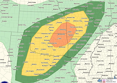
Here is the NWS Storm Prediction Center's (SPC) overall severe thunderstorm (defined as large hail, tornadoes and damaging thunderstorm winds) risk map from 1am Tuesday until 5am Wednesday (those are my times).
I completely agree with this forecast as to the overall threat:
Between 1am and mid-morning, large hail may occur in Oklahoma north of I-40 and in southern Kansas and southwest Missouri.
The 4-State area of the corners of Kansas, Missouri, Arkansas and Oklahoma have the relatively highest threat of large hail, damaging winds (especially), and a few tornadoes throughout the entire forecast period.
The above forecast map does not separate out the tornado threat, so here is my assessment of that risk. This does not rule out a stray tornado in other areas, just that this area has a relatively higher level of risk.
While I have a little less confidence in this forecast than usual (due to morning thunderstorms perhaps washing out the air mass in places), I recommend checking back mid-morning tomorrow to receive an updated forecast.
Regardless of whether you live in my risk area or SPC's yellow or orange regions, I recommend you keep up with the weather tomorrow. Make sure your tornado shelter is ready to go and that lawn furniture and other items that can blow about are brought in. Put your car in the garage or under the carport. If you live in a mobile home, consider other shelters well before strong thunderstorms approach.
Note: There is also a chance of tornadoes and severe thunderstorms over much of this area on Wednesday.
 |
| click to enlarge |
Between 1am and mid-morning, large hail may occur in Oklahoma north of I-40 and in southern Kansas and southwest Missouri.
The 4-State area of the corners of Kansas, Missouri, Arkansas and Oklahoma have the relatively highest threat of large hail, damaging winds (especially), and a few tornadoes throughout the entire forecast period.
The above forecast map does not separate out the tornado threat, so here is my assessment of that risk. This does not rule out a stray tornado in other areas, just that this area has a relatively higher level of risk.
While I have a little less confidence in this forecast than usual (due to morning thunderstorms perhaps washing out the air mass in places), I recommend checking back mid-morning tomorrow to receive an updated forecast.
Regardless of whether you live in my risk area or SPC's yellow or orange regions, I recommend you keep up with the weather tomorrow. Make sure your tornado shelter is ready to go and that lawn furniture and other items that can blow about are brought in. Put your car in the garage or under the carport. If you live in a mobile home, consider other shelters well before strong thunderstorms approach.
Note: There is also a chance of tornadoes and severe thunderstorms over much of this area on Wednesday.


Comments
Post a Comment