Posts

Showing posts from April, 2019

Chase Log: April 30, 2019 Oklahoma

Image
Very disappointing day. I targeted southeast Kansas. However, as we drove in that direction, I learned the highway was completely  closed for construction. Re-routing would have cost us 30 minutes or so and I made the decision to go to central Oklahoma as my second choice. The red dots (below) are tornado reports. Map updated at 8:50am Wednesday The decision to go to southeast Kansas was excellent. Unfortunately, central Oklahoma was a poor second choice. We managed to find and chase the only rotating storm in that area which was during the rush hour. The storm (very fortunately!) did not produce a tornado. The one dot you see northeast of Oklahoma City occurred before noon -- before we arrived. Well, better luck next time.

11:20am Tornado Threat Update

Image
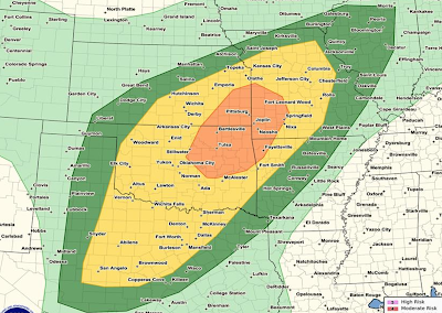
Here is the updated tornado threat map from the NWS SPC and I am in complete agreement. Brown = 5% is the significant threat area. This includes St. Louis, Springfield (IL), Oklahoma City, Wichita Falls and the far north portions of the DFW Metroplex. The yellow = 10%, enhanced, threat area. This includes Columbia, Rolla, Springfield (MO), Joplin, Ft. Smith, Fayetteville, Gainevilles, Tulsa and Norman. Within the enhanced threat area is the hatched area where strong  tornadoes are forecast to occur. This includes Gainesville, Ardmore, Shawnee and McAlester. If you live in any  of the above areas please monitor the weather starting at 1pm   immediately (see below).  Make sure your storm shelter or safe place is ready to go and make sure you have at least two methods for receiving tornado warnings. I will be chasing for the first time this season. You can monitor my activities at: @usweatherexpert on Twitter. Stay Safe! Three minutes after posting the above the first to

Today's Tornado Risk

Image
The significant tornado threat is the brown (5%) area which includes St. Louis, Springfield (IL) Wichita Falls, and the northernmost parts of the DFW Metroplex. The enhanced risk (yellow, 10%) includes Oklahoma City, Tulsa, Joplin, Springfield (MO) and Fayetteville. Please keep an eye on the weather if you live in these areas.

Tornado and Severe Thunderstorm Risks For Tuesday and Wednesday

Image
Here is the NWS Storm Prediction Center's (SPC) overall severe thunderstorm (defined as large hail, tornadoes and damaging thunderstorm winds) risk map from 1am Tuesday until 5am Wednesday (those are my times). click to enlarge I completely agree with this forecast as to the overall threat: Between 1am and mid-morning, large hail may occur in Oklahoma north of I-40 and in southern Kansas and southwest Missouri. The 4-State area of the corners of Kansas, Missouri, Arkansas and Oklahoma have the relatively highest threat of large hail, damaging winds (especially), and a few tornadoes throughout the entire forecast period. The above forecast map does not separate out the tornado threat, so here is my assessment of that risk. This does not rule out a stray tornado in other areas, just that this area has a relatively higher level of risk. While I have a little less confidence in this forecast than usual (due to morning thunderstorms perhaps washing out the air mass in plac

Single Dumbest Sentence About Global Warming Ever Written

Image
Given all of the propaganda on written on this subject, the competition s stiff but here it is: If the earth has been "destroyed," where, exactly, are we living??

And, Speaking of Lightning

Image
[Scroll down for a posting about lightning and major league sports] At 5:40pm CDT, I grabbed this image of the combined lightning and radar data. The cloud-to-ground lightning (which is what this display depicts) is a full 32-miles ahead of the rain! This is what meteorologists call "anvil lightning" and it is just as deadly as any other kind. Remember, even if it is sunny, When Thunder Roars, Go Indoors!!

Kansas City Royals: Bad Baseball and Bad Fan Safety

Image
My son, son-in-law, and two granddaughters were at the Angels vs. Royals game this afternoon. The Royals played bad baseball and lost 7-3. But, even worse, was the Royals' lack of state-of-the-art weather safety for their fans. Because the Royals have not traditionally done well in this regard, I kept my family informed and, as the rain moved in, they moved under cover. Here is the lightning "play-by-play:" State Line Road is a very well known road in the Kansas City area that separates the states of Kansas and Missouri. The lightning was 7.7 miles southwest of the stadium. The game continued. I knew the lightning was there because of new technology that reveals in-cloud,  as opposed to cloud-to-ground, lightning. It uses the new GOES satellites. The image is below. The lightning is circled. Royals Stadium is at the tip of the arrow. Note: conventional lightning detection is cloud-to-ground and nothing was shown. Radar does NOT depict lightning. The display

Sunday Fun

Image
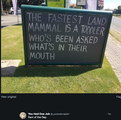
Above via Twitter.

The Vital Importance of the Tornado Warning System

Image
2018 Tescott, Kansas, Tornado We take the tornado warning system for granted. It saves hundreds of lives year and, in a year with more tornadoes than average, it saves thousands. But, what happens when the tornado warning system experiences a rare failure? What can we learn? How can we protect our homes and family? When the Sirens Were Silent  is the story of the 2011 Joplin Tornado -- the worst single tornado since the warning system began in the 1950's. The horrific death toll -- 161 -- was hugely inflated due to the deficiencies of the warnings that day. You can read the Washington Post's  review here . Because of the importance of the subject, I priced the ebook at just $2.99 because I want people to read and learn so nothing like this ever happens again.

Another Climate Record -- The Good Kind

Image
This map depicts a record -- a record low  amount of drought. Yellow is not drought. Only orange depicts areas in drought. Remember how, in 2013-14, we heard about a permadrought in the Southwest caused by global warming? Of course, the fact the record low drought falsifies another global warming hypothesis will have no effect on the quasi-religious beliefs of those pushing the catastrophic global warming hypothesis.

Please Follow Me on Twitter

While I no longer focus on weather on this blog, I do a lot with weather on my Twitter account: @usweatherexpert Not only is there weather coverage, when I storm chase I tweet plus I provide insights into topics that I find interesting. If you like this blog, I think you will like following me on Twitter.

Vaccinations

Image
I had many of these childhood diseases . They were a part of growing up in the 50's and before. Today, vaccinations provide children and their parents with peace of mind at very low or no cost. I urge people to get vaccinated -- and, if you are an adult, get the newer shingles and pneumonia vaccinations. As previously mentioned, we also have the tool to track relative disease risk. It is Diseasecast from Big Data Media and Ascel Bio. Right now, it shows a continued high relative risk of flu in the Northwest and far Northeast parts of the nation.

Important Tornado Forecast

My reading of the computer models indicates that the below average tornado season in the Great Plains will come to an end April 29. From there through mid-May (as far out as the computer models go), it looks like it will feature average or above average tornado frequencies. Tornado researcher Dr. Victor Gensini believes the entire month of May will be active.

Another 5-Star Review For "Warnings"

Image
There is a new review of Warnings  posted at Amazon: I expected this book to be interesting. But I didn’t expect it to be such a page turner. I couldn’t put it down. The writing is excellent. It has a good pace and kept me coming back for more. I love reading about weather, but I can’t say too many meteorology books have had me up in the middle of the night saying “just one more chapter!” This one did. The specific storm stories weave together the topics perfectly. I want to deliver a free copy to anyone who snarks about the weatherman never getting it right. They just don’t understand. This book shines a light on the everyday heroics of storm forecasters that go unnoticed and unappreciated. And it’s a fun read! Thank you, Jeepgrl! If you would like to read a great book about storms as we move into the heart of tornado season, click here for Amazon. For Barnes & Noble, click here .

Absolutely, Positively: Wind and Solar Electricity Raise Both Costs and Hurt Reliability

The details, in case you have any doubts, are here .

Drought Concern

I can't tell you why, exactly, but I'm increasingly concerned that a drought may develop over the Central Plains this spring and into the summer. This is a "gut feeling" rather than something scientific. I'm passing it along for what it is worth.

Is Global Warming a Cult?

Image
Of course! In fact, it isn't even close when comparing the movements' collective behavior to the Ten Warning Signs. See for yourself, here . Addition... Fortunately, the vast majority of Americans realize the global warming issue for what it is. Via Twitter.

HAPPY EASTER!

Mindy and I wish you a joyous and grace-filled Easter 2019. Bonus: How today's MSM would have reported the events of Good Friday, Holy Saturday and Easter. Friday: https://hillfaith.blog/2019/04/19/alert-authorities-execute-man-who-claimed-to-be-god/ Saturday:  https://hillfaith.blog/2019/04/20/controversy-erupts-amid-claims-man-named-jesus-survived-crucifixion/#more-1072 Sunday:  https://hillfaith.blog/2019/04/21/news-alert-authorities-scramble-to-explain-empty-tomb-of-jesus/#more-1085

The Allure of Farming

Image
Some boys want to be farmers and an insightful article explains why. My favorite paragraph: As Michael Gurian explains in his book,  The Minds of Boys ,  males are full of “boy energy,” an energy that “involves a lot of physical movement and manipulation of physical objects.” If channeled properly, this energy, although often annoying to teachers and mothers, helps boys to process, learn, and become innovators. Thus, a farm and the labor it offers becomes the perfect avenue for little boys to become independent and mature thinkers. It is surprising to me that some parents discourage their children from farming. It can be a great life. The view of the Kansas sky from a wide-open farm cleanses and inspires the soul.

Coverage of Tornadoes For the Rest of 2019

It is my goal to make people aware of serious threats due to weather even though meteorology is no longer the primary focus of this blog. However, now that the Middle Atlantic and the Great Plains have had their first tornadoes of 2019, I am going to stop coverage of typical spring tornado situations. I will cover especially dangerous situations. 

Dangerous Day in the Middle Atlantic Region

Image
Heads up: Raleigh, Charlotte, Columbia, Richmond and Charleston. Damaging winds and tornadoes are in today's forecast. Let's break it down. The more serious risk is damaging thunderstorm winds. The significant risk is 15%. The purple area is a high risk of 45%. The hatched area is where wind gusts are forecast to exceed 75 mph! There is also an enhanced risk of tornadoes. On this forecast chart, 5% (brown) is the significant risk threshold. The 10% (yellow) is an enhanced risk. How to prepare: Power failures will be widespread. So, get some extra cash at the ATM and fill your car with fuel well before the storms arrive. If you have a chain saw, fill it as well. [Remember, if power is out, ATM's and fuel pumps will not work.] Power failures could last several days. Fully charge your phone and PC before the storms arrive. Take them off the charger before lightning is present.  If warnings of extreme winds are issued, please shelter like you would a tornado. Pre

Something for VORTEX-SE to Research

Image
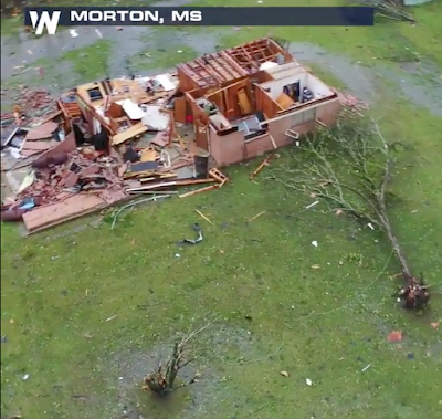
There is a major tornado research program pertaining to tornadoes in the Southeast. I would like to offer a suggestion for some serious research. I have been viewing weather radar on a virtually daily basis for 48 years. This afternoon, I saw a phenomena I've seen only one other time which was in the late 1970's in Kansas (I don't remember the date): a gigantic (as these things go) rotating mesoscale vortex that was not associated with a supercell thunderstorm that was apparently spawning multi-vortex, violent, tornadoes. I'm bringing this to research meteorologists' attention because I have not seen any coverage of it in the Mississippi media, so far. Why is this important? The answer can be easily seen in a video here . A screen capture is below. It is rare for non-supercells to cause tornadoes of EF-3 intensity which the above image suggests.  Here are some images of the radar data from this unusual storm. The "donut" centered just west of

Thank You, Dr. Roger Pielke, Sr.

Image
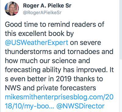
I was pleased to see this as part of my Twitter feed yesterday. If you would like to check out my book Warnings: The True Story of How Science Tamed the Weather, click here .

Validation of My Forecast

Image
I validate all of my severe weather forecasts for my readers as a way of holding myself accountable. I'm happy to report that yesterday's was a real stinker. I use the word happy because tornadoes did not occur where forecast and fewer tornadoes are always a good thing. Below is the forecast posted here yesterday. Below is the map of actual tornado reports (red dots = tornado). I take my forecasting seriously and I'll do my best to do better next time.

Today's Tornado Risk

Image
The brown area (5%) is the significant tornado risk threshold. The yellow is an enhanced risk and the hatching indicates strong tornadoes are possible. This includes Jackson, Hattiesburg, Gulfport, Mobile, Montgomery and Panama City. Please monitor the weather in these locations today.

Damaging Winds Are Forecast

Image
Above radar at 8:14pm CDT. The NWS SPC is forecasting that an area of damaging winds will form near the KS-OK border near I-35 and move east. This should began around 9pm with the threat ending by around midnight. This will be last update for the Kansas-Oklahoma severe thunderstorm threat. Update 8:30pm. No sooner did I post this than the storms rapidly began organizing. Below is the radar at 8:25pm. Especially in the northern two rows of Oklahoma counties a band of damaging winds is forming rapidly. Gusts of 65-70 mph may occur in spots. There could be power failures. 

Severe Thunderstorm Watch For Southern Kansas and Northern Oklahoma

Image
Good move by the Air Force to protect to protect their very expensive taxpayer-paid aircraft. Full article here . Just a few minutes ago, the National Weather Service issued a severe thunderstorm watch for large hail and for strong wind gusts up to 70 mph. I'm not particularly worried about tornadoes. Please put your car in the garage and bring in law furniture or other items that could be damaged by hail or high winds. UPDATE: At least 1" hail reported at or very near McConnell AFB. Their decision to move the aircraft was proactive weather risk mitigation at its very best.

Weather Forecast Snapshot

Image
Here is an experimental snapshot of the location of thunderstorms and the risks they pose for the period 6pm to 8pm. Please note the locations are approximate. Please keep up on the weather in these areas. 

Two Day Tornado and Severe Thunderstorm Forecast

Image
Forecast For Late This Afternoon and Tonight The overall risk of tornadoes is low (but not zero) north of the Red River. From the Red River counties of Oklahoma south into Texas, there is a good chance of a few tornadoes, with the better chance from sunset on during the night. Hail Unfortunately, hail may be the big event late this afternoon and tonight. The hatched areas (including Wichita and the DFW Metroplex) are where large, damaging hail may fall. Tornado Threat Thursday This is the day where there is a serious tornado threat if things come together as forecast. Where the hatching is located, there is an enhanced risk of tornadoes and damaging thunderstorm winds. I will update this forecast tomorrow morning.

Oops, Forgot to 'Look Out the Window'

Image
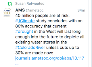
Early in their careers, television meteorologists are told to always look out the window right before presenting a weathercast. It can prevent embarrassment. Unfortunately, the American Meteorological Society (AMS) metaphorically forgot to look out the window before publishing this tweet yesterday afternoon. There's only one problem: the drought ("80% accuracy"!!) has ended. Here is a map of the Colorado River's watershed. Below is a map of the current drought situation. The Colorado River is on the base map. Almost none of the Colorado River's drainage area, except northwest New Mexico, is in drought. The other generally accepted drought index shows above normal  moisture conditions over much of the basin. The only drought is over a small portion of western New Mexico. Most of the Upper Colorado watershed in Colorado has above average snow cover, a full 30% above average. So, this is a case of the AMS organization crying wolf. When it in