Posts

Showing posts from February, 2019

Why I Am Not a Fan of Long Range Forecasts

Image
Here is NOAA's temperature forecast for the meteorological winter (December through February) 2018-19. And, here are the actual temperatures: The forecast is almost exactly backward. Unfortunately, this is not rare. In spite of nearly 50 years of trying to forecast seasonal weather, there is very little skill to long range forecasts. The atmosphere is too chaotic to reliability  forecast beyond about two weeks. Keep this in mind when Big Climate is telling you they can forecast the weather or climate 30 or 50 years in the future. Can't be done.  Hat tip: Dr. Mika

If You Are in a Winter Storm Multi-Car Pileup, Stay in Your Car!

Image
Screen shot from Oklahoma City's KOCO TV live shot this morning. They happened to catch a multi-car pileup as it occurred. A woman, carrying a child, got out of her car and the white Mustang narrowly missed her as it added to the carnage. Unless your car is on fire, there is fuel leaking or some other compelling reason, stay in your car if you are in one of these unfortunate events.

Tornado Season Could Be a Bad One in Tornado Alley

Image
After two years of well below normal numbers of tornadoes in the Great Plains.... I am not a long range forecaster, my specialty is short range (~3 days and less) forecasting and warning of extreme weather. So, I am posting AccuWeather's forecast for tornado season. I have no sense of the forecast's quality. However, last year was far below normal in terms of number of tornadoes in the central Great Plains, so it would seem logical that this year may be worse. If you would like information about preparing for tornadoes and the horrible consequences when things go wrong, go here .

Fake News About Global Warming

Image
This is about a silly piece of 'research' indicating fewer people are tweeting about extreme weather. The more likely hypothesis as to fewer weather tweets is there is less extreme weather.  For example, Twitter launched in 2006. There was a peak in number of strong tornadoes in 2011. Since then, the number of strong tornadoes has dropped rapidly (continuing a trend since the 1970's). Thus, fewer people are tweeting about tornadoes. The number of tweets would also be influenced by whether disasters occur in heavily or lightly populated areas, etc. Unfortunately, the MSM will fall for any story that advances the catastrophic global warming 'narrative.'

Thank You, National Weather Service

Image
I want to recognize the NWS for doing the right thing. They are going to indefinitely delay the roll-out of a new forecasting model that was a big step backward. This is a courageous decision. They should be applauded for doing the right thing.

Proof That Global Warming Is a Religion

Image
Science does not use words like "atone." Details here . Global warming advocacy has become a complete joke.

Am I the Only Person...

...who is tired of the phrase, "the conversation"?

Validation of the Blizzard and Tornado Forecasts

Image
Blizzards are rare but events with extremely high impacts. So, it is important to validate the quality of forecasts versus what actually occurred. I also compare the tornado outlook yesterday's storms. It is dismaying to learn of the apparently hundreds of autos that got stuck in the storm, especially to the north of Kansas. One of my motivations for presenting these validations is to convince people to take warnings seriously. I doubt that anyone on I-80 who just had to spend the night in the freezing cold would want to do it again. Blizzard Validation These were the early blizzard forecasts: Posted 5:12pm Wednesday: Posted at 9:28am Thursday. The track is a little south but overlaps the actual track. The forecasts just got better from there. By Friday, we had pretty well locked on to the blizzard's path. Here is the actual snow from yesterday's blizzard (yellows and oranges are snow melt). As of this posting, they are still  widening the closure of I-

Sunday Fun: A "Dad Joke"

Image
These are known at The Smith House as a "Dad Joke."

Final Update on Blizzard and Tornado Risks

Image
As of 7pm, the worst of the blizzard is in the outlined area. Things worked out pretty much as forecast with amounts (so far reported) of up to 11", three foot drifts and numerous road closures. Some power failures, but extent unknown. Updated 7:16p. NWS sent outdated map.  Orange is current blizzard warnings. Pink is a winter storm warning. The tornado watch in Mississippi will expire at 8pm. The tornado watch in Tennessee and Alabama will expire at 10pm. There have been numerous tornadoes today with serious tornado damage in the City of Columbus, Mississippi.

Tornado Watch: Tennessee and Alabama Until 10pm

Image
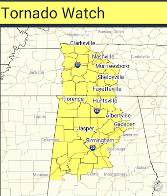
Includes Birmingham, Huntsville and Nashville. Please monitor the weather in this area. 

First Tornado Watch of the Day

Image
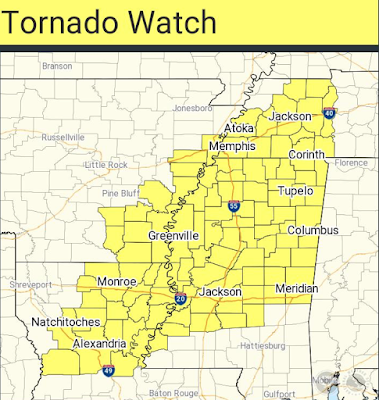
It is for parts of Mississippi, Louisiana and Arkansas and Tennessee until 8pm CST. There is a "high" risk of strong tornadoes.  The tornadoes will move quickly -- at Interstate highway speeds. It is critical to monitor the weather in your area while the watch is in effect.  Additional tornado watches will almost certainly be issued as the threat evolves. It is critical that people in the tornado watch monitor the weather the rest of the day. Please use multiple sources to receive warnings.

11am Storm Snapshot

Image
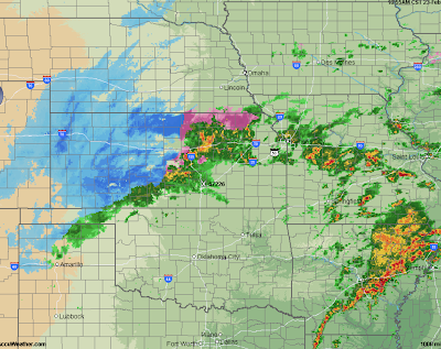
Ten inches of snow have fallen south of Garden City, Kansas, with snow thunderstorms near Dodge City. Highways are being closed as I am writing this. In the Mississippi Valley, storms are bringing more heavy rain increasing the already high flash flood risk. Strong tornadoes are likely this afternoon and this evening. The first tornado watch of the day will likely be issued in the noon to 1pm time frame in the outlined area. This includes Jackson, Monroe, Alexandria, El Dorado and Vicksburg. Please monitor the weather throughout the regions in yellow/orange/red here . 

High Risk of Flash Flooding

Image
As if there wasn't enough "weather" today: a high risk of flash flooding is forecast for the Tennessee Valley, including Nashville, Huntsville and Tupelo. This is a very serious situation. I would recommend not traveling in this area unless absolutely necessary. If you do drive, remember: turn around, don't drown.  UPDATE  This is the rainfall that has fallen over the last seven days. Additional heavy rains today and tonight will cause severe flash flooding.

8:35am Blizzard and Tornado Risk Update

Image
Tornado Risk. There is a significant risk of tornadoes in the yellow area beginning in the afternoon. If you are in the orange or, especially, red areas you are at risk of strong tornadoes. What makes today potentially deadly is that the storms will move extremely fast: 60 to 70 mph. This means you may have less time to react than usual. So, Clear out your shelter area now.  You will want to have multiple sources for the warnings. Television with a trusted meteorologist, a NOAA Weather Radio, and a smartphone app like AccuWeather's with location services turned on.  Monitor the weather starting this afternoon. Make sure friends and relatives are aware of the threat.  Blizzard Here are the final forecast snow amounts. Travel should not be attempted in the blizzard warning areas (orange, below). Power failures are also possible.  Orange is a blizzard warning. Pink is a winter storm warning. Red is flash flood warnings. Browns are high wind warnings. Greens are fl

Why Big Climate Hates Nuclear Energy

Image
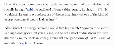
As we have discussed many times, it is about politics and political control, not the environment. More evidence: Yup, nuclear would mean too much prosperity. The entire (excellent) article is here .

11:38pm UPDATE to Saturday's Tornado Risk

Image
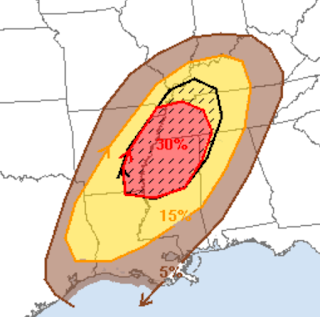
This is very serious. I believe this is a situation where people potentially die. There is a risk of tornadoes Saturday throughout the 5% (brown) area. The 15% (red) area has a serious risk. The hatched area is where violent tornadoes are forecast to occur. When you combine strong tornadoes with rapid forward speeds of 60-70 mph, there may not be adequate warning time. It is vital to monitor the weather all day. I would use TV, NOAA Weather Radio and a reliable phone app like AccuWeather's (with the location feature turned on). Please have your shelter area cleared out and read to go at a moment's notice. I will update Saturday morning.

Dangerous Flash Flooding the Rest of the Night

Image
If you are in the scalloped brown area, there is a serious risk of flash flooding the rest of the night. The flash flooding will be serious and life-threatening. In the words of the NWS.

8:30pm Friday: Quick Blizzard and Tornado Threat Update

Image
SEE UPDATE REGARDING BLIZZARD The threat of tornadoes exists after 2am Saturday morning until about 10am Saturday with a more intense threat tomorrow afternoon and evening throughout the yellow area. The hatched area is where violent tornadoes could occur during the afternoon and evening. Because the any tornadoes will have forward speeds of 60-70 mph please monitor the weather throughout the day. Use a TV, NOAA Weather Radio or app like AccuWeather's (with location services enabled) to get warnings as quickly as possible. Due to the extremely fast speed, there may be less advance notice than usual. Little change in the track of the blizzard  with amounts increased somewhat. I am confident Interstates 80, 29, and 70 will be closed. Interstate 135 near Salina will probably be closed. The smaller areas where the purples are darker are indications of local amounts of over a foot due to snow thunderstorms. However, the model cannot resolve these exactly, so please keep in mind

Pre-Dawn Saturday Tornado Risk

Image
Ahead of Saturday's major tornado risk... The brown area, which includes Monroe, Vicksburg and Tupelo, is a significant risk of overnight tornadoes between 2am and 6am Saturday. Make sure your NOAA Weather Radio and/or smartphone app is ready to go. The data since this morning indicates tomorrow's risk for serious tornadoes is, if anything, higher than I originally thought. I'll update on the storm tomorrow morning. Please check back.

Incredible Photo -- Really Foolish Actions By Padres

Image
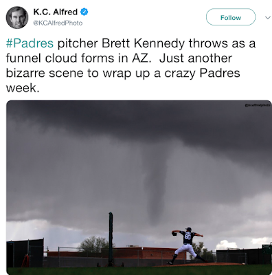
Wow. Yes, that is a funnel cloud. I don't care whether is was moving toward or away from the park but it is foolish to have players (or anyone!) outside in that type of weather. The Padres need to have a commercial weather company monitoring the weather for them.

Blizzard Warnings Now in Effect

Image
Orange = blizzard warning. Browns are high wind warnings. Pink is a winter storm warning. Dark green is a winter storm watch. Blue is a winter weather advisory (a lesser condition). Scroll down to see the posting about the winter storm.

U.S. Soil Moisture

Image
The execs soil moisture may delay spring planting in parts the Tennessee Valley given forecasts of additional rainfall. The winter wheat crop has plenty of moisture at this time. Addition: Here is the 7-day rainfall ending at 7am this morning.

Facebook = Creepy

Image
This is the fourth story of this nature this week. From the Wall Street Journal:

Tornado and Blizzard Update

Image
Great Plains - Midwest Blizzard There will be a blizzard in the central U.S. this weekend. The track of the heaviest snow will be on the northern side of the area outlined yesterday. This means Omaha, Lincoln and Ames will be significantly affected. I'll simply present the two best models as their tracks are identical. I have cross-verified this forecast by using some techniques that are independent of the models and am confident in the overall pattern of snowfall. I believe the maximum snowfall in this storm will be about 13" with broad averages of 5-8 inches. However, winds will gust to 55-60 mph in southwest Kansas and up to 40 mph in northeast Kansas and southwest Iowa. This will cause serious drifting of the snow. I expect I-70, I-80, and I-29 will be closed by this storm. Two important considerations: Power failures are possible due to the wind and the potential for snow to stick wires. Life-threatening travel conditions. One word: don't.  Here is a

"Duck and Cover" Really.

It is a black swan that gets you: Some really good advice in this age of terrorism and actors like Iran and even China.

Now: A Bad Privacy 'Surprise' From Amazon

Image
Here's a [not!] shocker: Yes, you just paid to gave Amazon executives live images outside, and if you purchased their indoor security cameras, and inside of your home. Details here . Google, Facebook, Amazon and their ilk most certainly do not have their customers' best interests at heart.

Blizzard and Tornado Threat Saturday and Saturday Night

Image
The first major tornado threat of 2019 plus a blizzard are forecast for Saturday. [3:40pm: No update to the information below] [9:25pm: No update to the snow forecast locations but amounts may be somewhat heavier than forecast. This raises the specter of power failures Saturday into at least Sunday due to the wet snow.] Let's begin with the tornado threat . The yellow areas are where you should plan to monitor the weather Saturday and the hatched area is where strong tornadoes and violent thunderstorm winds may occur.  The storms will move very, very quickly -- perhaps 70 mph -- which means there will be less warning than usual.  There is some possibility the forecast threat area will have to be extended westward in the Ozarks. Blizzard. Winter weather forecasting is difficult, but because this could be a life-threatening storm so I am providing forecasts farther out than usual. The map is a preliminary  forecast of snowfall amounts and locations to 6pm Saturday. Add