Posts

Showing posts from May, 2018

The Good News: Hurricanes Are Not Getting More Frequent

Image
As readers of this blog know, many in Big Climate want us to believe hurricanes have gotten worse as a result of global warming. Their hypothesis and concerns are not justified by the data.  I'm feeling a little better today and I wanted to get this important information to our readers. It is freshly updated information from tropical weather expert Dr. Ryan Maue and it computes almost fifty years of hurricane/tropical storm frequency and the Accumulated Cyclone Energy index (ACE) which is the total energy of tropical systems. Frequency of Hurricanes and Tropical Storms Worldwide click to enlarge Total Energy From Tropical Storms and Hurricanes   The upper line on the upper graph clearly demonstrates there is no increase in hurricanes. None. There is a slight increase in tropical storms but it likely that better satellite monitoring is allowing weak tropical storms to be found and named that would not have been the case 20-30 years ago. If you are interested, Dr. Chri

No Updates Next Few Days

Due to illness. Sorry. I am still doing some postings on Twitter @usweatherexpert .

Heads Up Late This Afternoon and Evening

Image
Here is an updated forecast of dangerous thunderstorms for later this afternoon.  I have been looking at the latest data and I'd like to update the forecast I provided below. The area outlined in southern Kansas and northern Oklahoma is where tornadoes are most likely and I do expect several.  The orange area is where the NWS and I are expecting very large hail (≥2") and straight line thunderstorm wind gusts of 60-65 mph. In the yellow, severe thunderstorms (1" hail, gusts to 60 mph) are possible but on a less concentrated basis.

Tuesday's Tornado Risk

Image
The orange area is where hail larger than two inches in diameter is likely. Tornadoes are possible in the western half of the orange area. Please pay attention to the weather later today.

"Cows!!"

Image
Storm chasers often deadpan the immortal line, "cows," from the movie Twister.  Tragically, a tornado in southeast Wyoming this afternoon, caught by AccuWeather's Reed Timme r , went through a herd of cows and they went flying. Fortunately, this area is very sparsely populated and, so far, no injuries to humans have been reported.

Sunday Fun: Why I Prefer Hamburgers to Salad

Image
Actual quote from a restaurant inspection report Friday: I prefer a good burger to killer salad dressing!

Politicians Screw Things Up Again

The real  opioid crisis, of under treating pain, is about to get much worse .

No Cookies, No Advertising, No Hassle

Image
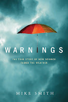
Sometimes we do not notice good things. Yes, as the author of this blog (with occasional co-authors), I received the legal notice about notifying readers about cookies, etc., that you are now undoubtedly seeing on other sites. Notice that you did not get the cookie notice here because there are no cookies with the blog. There is also no advertising with this blog with the exception of my books. Think of how pleasant it is not to have popups or other annoying advertisements!   So, in return for the value I hope you feel you are receiving from this blog, I'd like you to consider purchasing one or both of my books; Sirens  or Warnings . Both books are highly rated by readers and will make great summer reading.

45th Anniversary of Union City Tornado

Image
I was reminded earlier this evening that it is 45th anniversary of an exceptionally important storm: The Union City, Oklahoma, Tornado. We probably learned more from this tornado than any other single storm in history.  Doppler Radar NSSL Norman Doppler Radar While a Weather Bureau experimental radar in Wichita demonstrated Doppler radar could be used to detect tornadoes in 1958, that analog Doppler was completely impractical for real-time storm diagnosis and warning. In the 1970's, the National Severe Storm Laboratory (NSSL) ran two Doppler radars, one in Norman and the other in Cimmaron, Oklahoma. The Union City storm was in the perfect location to be tracked during its entire life-cycle by both. One radar tracking the storm would have been a step forward. Two meant, for the first time, a 3-D mapping of the winds could be done. Storm Chasers The year before, the first organized storm chase program in history began. For Union City, there were two chase teams that interc

VITAL Information: Recognizing Drowning. It Does Not Look Like You Think!

With Memorial Day and summer coming up, please  read this article . People, who could easily be rescued, drown all the time because people don't recognize what drowning looks like.

As 'Cheap' Wind Energy Gets More Prevalent, Why Are Electric Rates Going Up?

There is an easy-to-follow explanation here . P.S. After posting this, I learned that Westar Energy, my electric provider, is raising its rates because of wind energy.

Weather: The All-Purpose Excuse XXIV

Image
I can't count the number of times I have written about businesses using "the weather" as an excuse for poor results. Finally, The Wall Street Journal  has called one of them on it.

Seven Years Since Joplin Tornado

Image
Joplin tornado, 5:35pm, before reaching the city. Photo taken from behind by the Basehunters. Used under license agreement. Path of Joplin Tornado Today is the anniversary of a terrible, terrible occasion: the Joplin Tornado of 2011. There were 161 people killed. The number of deaths was inflated due to issues with the warnings; it was the worst failure of the warning system since it began in the 1950's, and due to the fact the tornado could not be seen as it moved across Joplin (the photo above was taken from behind). The photo below was taken from the path of the tornado looking right at the tornado. It was invisible. Photo by Jaime Green People could not see the tornado coming nor were they receiving an effective warning. The story of what went wrong is in my book, When the Sirens Were Silent .  It is a dramatic story that illustrates how to make sure nothing like this happens again. Sirens  also contains comprehensive tornado safety rules for home, for schoo

Yes, Catholics Believe God Loves All of Us

Image
As a Catholic, I found this morning's headlines both accurate and misleading. It is accurate because... Catholics believe, 100%, God loves everyone. Period. It makes no difference whether a person is gay or straight, male or female. God loves us all the way we are! I am very pleased Pope Francis has again reiterated that God loves gay people as much as He loves straight people. It may be misleading because... Some are taking the Pope's quoted words to mean that sex outside of traditional marriage is now permitted by the Catholic Church. This is not correct and it equally applies to people who are gay and who are straight. Hopefully, this is helpful to those trying to figure out what this means.

It Was a Weather Balloon

Image
Geez. The Atlanta overreaction .

Graduations, Vacations and Father's Day: A GREAT Book As a Gift to Give or To Yourself

Image
I hesitated to post this review on my blog because it is rather long. However, since it is graduation season and Father's Day is coming up, I urge you to consider purchasing it as a gift or as reading for your summer vacation. You will not be disappointed! Book Shark 5.0 out of 5 stars Warning! This Book Will "Blow" You Away Published on Amazon.com Verified Purchase Warnings: The True Story of How Science Tamed the Weather by Mike Smith " Warnings: The True Story of How Science Tamed the Weather " is a fantastic book that captures the evolution of meteorology through the personal accounts of Mike Smith. Like the perfect storm in which converging elements collide, this book is part memoir, part science and all real.  This wonderful 304 page-book is composed of the following twenty-three chapters: 1. The Ruskin Heights Tornado, 2. No One Ever Knew it Was Coming, 3. "Nice People, But Odd", 4. The Government Gets in Gear, 5.T

Sunday Fun

Image
Nothing I can add.

100 Years Ago Sunday: Anniversary of the Last of the Legendary Codell, Kansas, May 20 Tornadoes

Image
"Weatherwise" Magazine, June, 1977 Sunday is the 100th anniversary of one of the most unusual events in the history of meteorology: The third of the May 20th Codell, Kansas, tornadoes. They are so unusual most all basic meteorology textbooks mention them and many popular publications have written about them, including Readers' Digest  and many others. Think about it: A tiny Kansas town of 150 hit by tornadoes on May 20, 1916; May 20, 1917; and May 20, 1918! Codell, in north central Kansas, north of Hays, was a bustling town along the Union Pacific Railroad early in the 20th Century. It had all of the trappings of a prosperous small town in America at the time of the first tornado: passenger railroad service, bank, hardware store, hotel, churches, grocery store, lumber yard and even an opera house. I learned all this when I visited the town and interviewed the late Howard Hockett , a survivor of the tornadoes, for a 1977 article in Weatherwise  magazine. He to

What I Was Doing Five Years Ago At This Time

Image
This tornado was southwest of Wichita in southwest Sedgwick County.

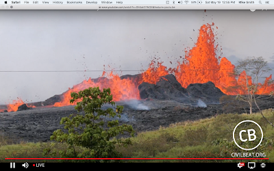
Live Feed of Kilauea Erupting

Image
Specular sights and sounds here . Highly recommended.

Thought of the Day

Drones, like kites, will find any tree in the area.

It is Long Past Time For the Senate to Confirm Barry Myers as the Head of NOAA

I know Barry well and I worked with NOAA for 47 years. NOAA desperately  needs his visionary leadership. Please read more here , then email your Senators.

Tom Wolfe, Rest in Peace

Image
I was saddened to read of the passing of the great American author, Tom Wolfe. He was a giant of American literature. His  The Right Stuff  is my favorite book along with the movie of the same name. Since angels are depicted as wearing all white, Tom won't even have to change clothes in the afterlife.

A Year Without Electricity

It would take us back to the 1880's. A newly declassified government report .

HAPPY MOTHER'S DAY

Image
Happy Mother's Day to all of my readers. I am blessed with wonderful parents. This photo was taken on Mother's Day last year and I want to thank my Mom for all she has done for me and for our family.

More Global Warming Nonsense

Image
I would be nice to watch a national newscast without a ridiculous allegation pertaining to global warming. This was on NBC Nightly News  Wednesday. So, global warming-caused warmer-than-average spring temperatures that caused more pollen? Apparently, NBC News couldn't even read the newspaper headlines from the same day as their broadcast. This is not a "mistake." If all of these were genuinely mistakes they wouldn't all be in the same direction -- making global warming seem worse than it is. 

Tornado Season is Cranking Up: Are You Ready??

Image
The longer range meteorological forecast data indicates that the potential for tornadoes, severe thunderstorms (large hail and damaging thunderstorm winds) and flash floods will increase from this weekend through at least the end of the month. That does not  mean these storms will occur every day. Plus, beyond about five days, we can't pin down locations. This "heads up" is simply to point out that our exceptionally mild 2018 tornado season to-date is going to quickly come to an end and it is time to prepare in earnest for tornado and severe storm season. I wish to recommend my short, easy-to-read book that will help you prepare for these violent storms. When the Sirens Were Silent  provides tornado safety rules for school, work and for home. It tells the story of the 2011 Joplin Tornado. One-hundred sixty-one were killed because the warning system failed to properly perform that horrible Sunday. Sirens  tells you what went wrong and how to avoid those issues goi

Storm Chase = Great Clouds

Image
Storm chases aren't entirely about violent storms. They are also about seeing spectacular Kansas skies. These photos were taken a May 1 in central Kansas. The photo above is a cumulonimbus cloud seen west of Hoisington, Kansas. Below are hail streaks southwest of Hoisington, Kansas. Supercell thunderstorm west of Great Bend, Kansas, with the 2018 winter wheat crop in the foreground.

A New Way to Forecast Tornadoes? Maybe.

Tornadoes are well known for the sounds they make. Turns out they also make infrasound which might be used in the future to warn of their development .

Disruptive Dust Devil Dings Fans

Yes, a dust devil can disrupt your baseball or softball game. Watch this!! You gotta watch this! Here's that same dust devil up close and personal sweeping across a softball diamond in Vulcan, Alberta. Luckily no one was injured as the chairs and gear went flying. Video via Cardston Junior High School teacher Kendall Hardy. #Canada #Alberta pic.twitter.com/sO9dfG2xGB — Mike Seidel (@mikeseidel) May 7, 2018

Superb Takedown of Another Global Warming Scare Story

The Washington Post   does it again . They have sadly surpassed the New York Times  in overhyped global warming coverage. The Post  used to have excellent weather and climate coverage. Unfortunately, it has drifted leftward during the Trump Administration even though weather should be about as non-political a topic as one could get.

Happy National Train Day!!

Image
May 5 is National Train Day.  In keeping with this special occasion, my brother, his wife, Kathleen and I had lunch on the Jess & Jims Patio in Martin City, Missouri. Our friends at the Union Pacific put on quite a show for us! Sister-in-law Robin is the good looking one! Hope you waive to a train today!!

Read Some Very Nice Things About Wichita and Kansas...

... The Atlantic . It is quite optimistic about Wichita and Kansas' future and our contribution to the national economy.

Tescott, Kansas: "Most Fortunate Town in the Universe"

Image
Alternate headline: Tornadoes Test Tescott Someone(s) in the town of Tescott, Kansas, has been living right. The map below is the Alma, (a/k/a Topeka) Kansas, WSR-88D  Doppler wind data. Wednesday, a tornado of moderate (there are no 'minor' genuine tornadoes) intensity passed two miles NW of Tescott (left). From Stu Ostro, Via Twitter Tuesday, the strong  tornado I chased (story here ) passed just one mile southeast of Tescott (right). That tornado has been rated EF-3 which means it was a strong tornado. I believe it may have been stronger than that. One of the weaknesses of the EF-Scale is that unless a tornado strikes substantial structures, it cannot be rated higher than a 3. Of course, we are very pleased the tornado missed the town (and the chance at a higher rating). I am going to do a more comprehensive posting about Tuesday's chase and the corresponding radar in the next few days.

Great News

Image
Courtesy of Dr. Roger Pielke, Sr.

Can Meteorologists Really Forecast Tornadoes?

Image
As Kathleen and I were in a McDonalds at McPherson, Kansas, checking data yesterday [May 1], I overhead the following conversation from two men seated behind us: First man,"Looks like we might have tornadoes later today." Second man, "Aw, those weathermen don't know anything; must be nice getting paid for being wrong all the time." This attitude is not just annoying to meteorologists, it is  dangerous.  If you do not believe meteorologists are skillful at forecasting tornadoes, you are less likely to prepare and then shelter when a warning is issued.  So, how good or bad was yesterday's forecast? Below is my tornado forecast from yesterday: And, from the SPC, the red dots are where tornadoes occurred yesterday. As far as I can tell, every tornado was in the tornado forecast area. 21 for 21 tornadoes. The forecast was posted on this blog at 9:50am. Again, per SPC, the first of the tornadoes occurred at 5:37pm: nearly 8 hours of advanc

An Amazing Storm Chase

Image
Kathleen and I had an amazing storm chase today. The first part of the chase was rather frustrating with many small funnel clouds (at the left side of the lowered cloud base known as a "wall cloud"). However, things got more serious as the storm approached Interstate 70 west of Salina. I saw a tornado about 5 miles north of the highway (MM 232) at 735pm (no photo, I was driving). We got off I-70 and went north on Brockville Road and saw a multi-vortex tornado rapidly develop. It rapidly widened and increased in intensity as it moved northeast. The video below shows the very rapid rotation in the wall cloud and the tornado which appears as a black smudge under the right side of the wall cloud. Click on the arrow. My friend, Reed Timmer, of AccuWeather, got the tornado at the same time from a different angle. Again, the tornado is the black "smudge." Here is a spectacular closeup about this same time. Unfortunately, the tornado was doing damage