Posts

Showing posts from March, 2018

Last Day at AccuWeather

Image
Today is my last day at AccuWeather. View of Wichita to the west of Downtown today; KSNW Ch 3's image I want to thank this amazing team of people for all of the happy times we spent together battling Mother Nature and taking care of our clients. I'll have more to say about my retirement later in the weekend.

Thank You Mayor Longwell!

Image
From right: Mayor Jeff Longwell, yours truly, and AccuWeather's Jon Porter and Marshall Moss I would like to give a special thank you to Wichita Mayor Jeff Longwell for making a surprise appearance at my AccuWeather retirement party yesterday. Mr. Mayor: Your words were very gracious! I also want to thank the entire AccuWeather team (especially you, Amber!) for putting on such a wonderful celebration. I was deeply touched and I will miss you all.

My Interview With "MarketWatch"

If you would like to read my pre-retirement interview with MarketWatch  it is here .

Another Day With a Tornado Risk

Image
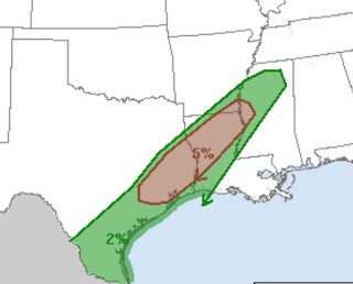
The brown (5%) area has a significant risk a tornado today. That includes New Orleans, Gulfport and Mobile as well as points inland. Please keep an eye on the weather in this region today.

Significant Tornado Risk Today

Image
The brown area (5%) is a signifiant tornado risk. It includes Houston. Please keep an eye on the weather later today.

No Question, It's Not Even Close: All Scientific Data Should be Public

I don't think I've ever linked to Hot Air before but this time they are right on the money .

Serious Flash Flooding Threat

Image
This is valid until 7am Wednesday. Please use extra caution, especially in the "red' area.

The Folly That is Wind Energy

So, in effect, we have come around full circle. A hundred-plus years ago, wind energy was recognized as an antiquated, unreliable and expensive source of energy – and now, after hundreds of billions of wasted tax and consumer dollars, we find that (surprise!) it still is an antiquated, unreliable and expensive source of energy. This is what happens when science is relegated to a back-of-the-bus status. The entire piece is here .

Wichita Eagle Article About My Career

The Eagle  has written a very nice article about my career and pending retirement. If you would like to read it, it is here .

Weather Control! Why Didn't I Think of That?

Chemtrails! Big Chocolate controlling the weather ! Looks like I spent my career on the wrong things.  ;-)

Seventy Years Ago Today

The first modern tornado forecast by two airmen at Tinker Air Force Base in Oklahoma. The entire story is told in Warnings: The True Story of How Science Tamed the Weather . 

Sunday Feature: The Value of Independent Thinking in Business

A great piece, here .

"I'll Believe Global Warming is a Crisis When the People Telling Me It's a Crisis Start Acting Like It's a Crisis

This headline is evergreen. You won't believe what the hypocrites at the New York Times  are doing to 'fight' global warming. BTW, I somehow got on their mailing list and the article accurately represents the expedition.

Please Don't Walk on Railroad Tracks!!

Image
Another senseless death; but maybe this time, some good will come of it .

Wise Words

Image

Yes, Tornadoes Occur in California

Image

My Retirement Press Release

As many of you know, I retiring from my wonderful career as a meteorologist on March 31. AccuWeather has sent out this press release if you would like to read it. I'll have more on my retirement between now and the 31st.

Illustration of Important Two Tornado Safety Rules

Image
This and other photos from last night's tornadoes demonstrate two of the important tornado safety rules. The tornado survivors are on the second floor  of the home. The lowest floor is relatively undamaged. Always go to the lowest level during a tornado warning. A basement is best. If not, get on the lowest possible floor and put as many walls as possible between you and the tornado. The lady is taking clothes out of her undamaged closet . The extra set of walls can make all the difference if a tornado strikes.

Dangerous Flooding Likely in California

Image
The yellow areas in the Sierra and in southern California are where more than ten inches of rain are forecast the next five days. This could result in serious flooding, especially in the burn areas between Los Angeles and Santa Barbara.

Another Success for Weather Science

Image
A violent tornado struck Jacksonville, Alabama, last night -- in darkness. As far as it known there were no fatalities in last night's swarm of tornadoes. Unfortunately, we have another day to deal wth this storm system. Note that the risk of tornadoes is "high" and the risk of strong tornadoes is "moderate." Please keep an eye on the weather today.

Significant Tornado Risk Today

Image
The significant tornado risk is in the brown with an enhanced risk in the yellow.

Major Snows in the Northeast

Image
Be prepared for major snows in several areas. AccuWeather has more details.

Two Tornado Watches; Tornado Warnings Starting to Be Issued

Image
The northern watch includes Nashville.  The southern of the two watches is a  particularly dangerous situation watch -- which is a rare category of tornado watch   issued when violent tornadoes are possible.  As of this posting, 4:36pm CDT, the radar below shows the first tornado warning of the day in northeast Mississippi to the northeast of Tupelo (red polygon). The storms in this line are forecast to intensify and produce tornadoes into tonight. Please keep up on local weather information. This will be the only update now that the storms are in progress.

Tornado Forecast Upgraded

Image
There is now a serious tornado risk in the area hatched below. This area now has a 15% chance of violent  tornadoes beginning on the west side of the area during the late afternoon and ending on the east side of the area tonight. This includes Huntsville and Birmingham. Some recommended safety procedures: Make sure your shelter is ready to go. Have a flashlight already in your shelter area. Bring an infirm friend or neighbor to your home by 2pm or so if they would have trouble getting to shelter on their own. Put heirlooms in the shelter area now. If a warning is issued, take your cell phone and wear sturdy shoes in case you are to walk out through debris. Have at least two ways (TV and the AccuWeather app, for example) of getting the warning. This is a situation for preparation but not for worry! Just keep up on the weather this afternoon and into tonight. 

Enhanced Tornado Risk Today in the Southeast

Image
The brown (5%) represents a significant risk of a tornado and I recommend you keep an eye on the weather in that area. The yellow is double that risk and the hatching is where violent tornadoes may occur. This includes Atlanta, Birmingham, Huntsville and Nashville. In this area it is appropriate to check on infirm friends and relatives and make sure they have a plan to get to shelter quickly should warnings be issued.

Tornado Threat in the Southeast Monday

Image
Because it is early in the season, I want to give everyone a heads-up about the tornado threat in the Southeast Monday.

Goodbye From Wichita

Thank you to all of our visitors for joining us for March Madness. We loved having you and hope you'll come back when we host it again in 2021!

Tornado Risk for DFW

Image
There is a risk of tornadoes northeast Texas, including the DFW Metroplex, later today. Please keep up on the weather. There is also the risk of very large hail in the the DFW Metroplex.

The Winner of the "Came the Longest Distance to the Party" Award

Image
From Australia to Wichita. The Wichita Eagle  has the entire story.

Tornado Risk in Central Texas

Image
The DFW Metroplex is on the north end of the significant (5%) tornado risk area. Keep an eye on the weather later today.

I Didn't Know This...

Image
This is "news you can use." Via Twitter.

Terrific Low Price For "Warnings"

Image
$16.17 is the lowest price I've ever seen for Warnings.  It is a wonderful, uplifting book for your spring or summer vacation. Who knows how long the price will last? Order now .

My Apologies to Wichita's NCAA Visitors

A couple of days each spring we have ridiculous winds. Today (naturally) is one of those days. The winds will be much lighter tomorrow and Sunday. Sorry you have to deal with this.

Attention Meteorology Grad Students....Attention Meteorology Grad Students

This essay is essential reading, along with the comment from Karen Lynn. But I knew nothing. I had assumed that the entire business world consisted of salespeople and paper pushers. I could either: (a) be a professor or (b) endure the soul-crushing monotony of corporate life. I didn’t choose the professoriate so much as I thought it was the only appealing choice... ... To be honest, I’ve found the for-profit world to be far more supportive of me as a person than academe ever was. Rather than being soul-crushing, working for "the man" has been liberating and allowed me to be who I want to be in the world. Plus, my parents aren’t terrified anymore, which is a nice perk. There are amazing, fulfilling, supportive, and meaningful jobs outside of higher education. So just quit. Or, rather, realize that deciding you are stuck doing something that is destroying you because of a decision you made when you were 21 is the real quitting. As a person who has been a meteorologist

Atlanta: Ten Years Ago Tonight

An amazing story of how a 3-point shot saved a tremendous number of lives . Attention: I can't find the program on the SEC Network's Listings on U-Verse in Wichita. This may be a regional broadcast. They have a strange definition of "today." It aired last night. Hope it is repeated at some point.

One Month Later....

Image
On February 14th, Wichita's Spirit Aerosystems sent off the 10,000 Boeing 737 fuselage and other parts via the BNSF Railway to Seattle. On Tuesday, voila, the 10,000th 737. To me, it is amazing they are able to turn the parts into a finished, pained airliner in a month. Congratulations Spirit and Boeing!!

Wildfire!

Image
With GOES-16's resolution, meteorologists can see the location of wildfires and the smoke plumes they produce. Here is a fire in Rice County of Kansas at mid-afternoon.

Northeast Flood Danger

Image
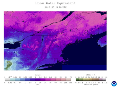
There is a growing flood danger in the Northeast, especially if the snow melts quickly.  click to enlarge The National Weather Service/NOAA have the ability to sense how much moisture is in a snowpack via satellite. The dark pinks below represent more than four inches water in the snow and the bright pinks represent more than five. If the snow should melt rapidly or if rain falls into the snow, there is a significant flood danger. Please plan accordingly.

For Basketball Fans Driving to Wichita

Our mayor just reminded everyone of the construction on east Kellogg near the East Wichita Kansas Turnpike exit. You want to avoid it and it is easy to do so. If you are coming from the south  (eg, from Houston through Oklahoma): Take Exit 42 from the Turnpike. Go north on Interstate 135 to Kellogg and go west a short distance to the downtown Wichita exit.  If you are coming from the north ( eg, from Lawrence): Take the El Dorado Exit. Go west on K-254 about 25 miles to Interstate 135. Go south on I-135. If your destination is downtown Wichita, get off at Second Street (one-way west).  Both avoid construction.

Global Warming: Is There Anything It Can't Do?!

Image

For Basketball Visitors: Bruce Northam's Guide to Wichita

Image
"One of the coolest cities in America." Published today is Bruce Northam's (Thrillist) guide . My only disagreement pertains to donuts..a critical issue. While the Donut Hole is unique and near downtown, I much prefer the gourmet donuts at Hurts (see my guide). Scroll down to see  my guide  to Wichita for those visiting for the NCAA Tournament. Whichever guide and donuts you prefer, we welcome you and hope all of the  basketball fans have a great time!!

Seven Day Precipitation Amount Forecast

Image
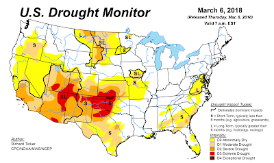
Unfortunately, the drought area of the central and southern Great Plains is going to miss out again.

Blizzard Conditions (Again) in the Northeast

Image
Yes, another blizzard in the Northeast. AccuWeather has the details here .

Basketfall Fans: Insider's Guide to Wichita

Image
Congratulations and welcome Houston, San Diego St., Michigan, Montana, Kansas, Penn, Seton Hall and NC State!! You won't find a friendlier city anywhere to celebrate with your team. Let me give you some idea what to do when you are not at Intrust Bank Arena watching your team: Airport When you step off your plane at Eisenhower National Airport, notice the glass jetways. They will take you inside to one of the most beautiful and modern airports in the nation. Usually, bag service is quite fast. Rental car is across the street in the parking garage. The airport is about 12 minutes west of downtown.  Hotels If you are staying in downtown: Ambassador (four diamond!), the Hyatt, Drury, Inn at Old Town, Fairfield or Courtyard Old Town you will be very pleased. You will also be very pleased with the full service Marriott in east Wichita. The Hilton Garden Inn at Bradley Fair is very nice, also.  Note: there are other nice hotels in Wichita but the ones above a

Sunday Fun: "Oh, What a Night!"

I'm happy to report that Jersey Boys  is returning to Wichita's Century II on February 19-20. Details here .

Above Average Tornado and Hail Season??

Image
Given the very slow start to the 2018 severe weather season, this forecast will either be in error or it will be a vicious April and May.

The Bad News Continues

Image

Wait! I Thought the Science Was Settled

High cholesterol linked to better brain function in the elderly. The "science is settled" is the dumbest phrase in the history of science.

Evidently "538" Does Not Know the Difference Between Variability and Predictability

Sheesh .

Northeast Winter Storm Underway

Image
Below are AccuWeather's latest snowfall amounts. More than one thousand flights are cancelled, so double check yours. However, I would not try to drive or fly into this storm.

Update on Looming Winter Storm

Image
For the second time in a week, I do not understand why parts of the Northeast are not under blizzard warnings rather than mere winter storm warnings. Please do not be misled. This will be another  major  winter storm. According to news reports, more than 300,000 are still without power from Friday's storm. The blizzard will put a halt to restoration efforts and may cause few additional homes to lose power. Let's begin with this update. Here is the radar at 5pm EST. Not much happening yet. At 8am tomorrow (Wednesday), the storm will just be beginning. Here is our latest forecast of total snowfall for this storm: And, here is our wind forecast. I have added where blizzard conditions are most likely to occur. Note, blizzard conditions may occur over a larger area than what I have noted. Flights are going to be a complete mess. Waivers have been issued. Use them. Another update tomorrow morning.

Don't Even Think About Traveling to the Northeast

Image
Another major storm to strike tomorrow.   Below are the warnings. Pink is a winter storm warning. Dark green is a winter storm watch. AccuWeather breaks things down. The high winds are going to cause more power outages and delay restoration from the last storm. The snows with this storm will be more widespread than with the last storm. The bottom line is that cancelling your trip is the wise thing to do. I've run the winter storm preparation tips so many times since last October, I hope readers know what to do. Good luck!!

Reminder.....

To get the totality of my weather coverage, please follow me on Twitter: @usweatherexpert .  This blog is: (c) 2018 Mike Smith Enterprises, LLC  All rights reserved. Please check out our web site a www.mikesmithenterprises.com

Major Winter Storm Beginning Tonight

Image
Another major storm is in the offing, this time in the High Plains and Intermountain Region. I have marked up all of the warnings and the winter storm watch. This includes a blizzard warning for parts of Nebraska, South Dakota and North Dakota. There are also high wind and extreme wild fire warnings for the central and southern High Plains. Below is a map of forecast snow amounts from AccuWeather . Use extreme caution  regarding travel in the blizzard warning areas.