Posts

Showing posts from February, 2018

"A Romantic in Kansas" Podcast

I am part of it (talking about 22:45 in) talking about, what else, tornadoes? If you'd like to listen, please click here .

Flooding, Round Two

Image
There is an enhanced risk of more flash flooding from Wednesday 6am to Thursday 6am. Of course, "flash" flooding is flooding that while the heavy rain is still falling or within hours of when the rain ends. Among the cities at highest risk are: Shreveport, Little Rock, Memphis, Nashville, and Huntsville. In addition, flooding is nearly certain in the areas outlined in red, whether flash (rapid) flooding or riverine (fancy word for river and stream flooding). Please: if you live in or near these areas, be aware of this hazard.

Climate: "Magical Thinking"

Image
Even those in favor of turning the world's economy upside down to stop global warming are finally catching up to the fact that the advocates do not seem to understand the implications of what they are proposing . As the highlighted editorial from the journal Nature  points out, many of them are engaged in "magical thinking." Heck, they can't even keep off their private jets to set a good example. And, yes, I'm speaking to you Al Gore, Hillary Clinton, Bill Clinton, Leonardo DiCaprio, and the founders of Google who have been outspoken about the needs to cut greenhouse gasses. Their (yes, more than one) are converted Boeing 767 jumbo jets fit for kings.

Yup!!

Image
click to enlarge

The Headline Speaks for Itself

Image
These are ordinary people volunteering to help clean up after a fatal tornado (scroll down). I appreciate the Tennessean  covering this important story. I hope the national media will, as well.

The Drought Deepens

Image
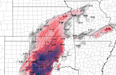
While the national news this morning is rightly filled with stories about the severe flooding in the Ohio and Arkansas River valleys, the drought deepened. The map, below, shows the problem. You can see the large area of ten inch plus rains in Arkansas, Oklahoma and Texas. But, in the areas of white and lighter blue in the High Plains. And, this deepens the drought. click to enlarge The map of Oklahoma highlights the problem. Over the southeast two-thirds of Oklahoma, the recent rains has helped. But, in the Panhandle and northwest Oklahoma, most areas of gone a record 140 or more days without significant rain (0.25 inches). The forecast, at this point, is not encouraging.

"Probably"

Image
The Chicago Tribune  has a story on the cities to visit for the first two rounds of the NCAA men's basketball tournament. It says this about our city: Wichita March 15 and 17 My trip to the most populous city in Kansas was to report a story on the state’s efforts to make teaching creationism* the law, so I didn’t spend much time in sports bars. But it’s the kind of small city that can be perfect for this type of guys trip. Let’s face it. A lot of dudes are simply looking for a comfortable hotel and a sports bar that serves cold beer and chicken wings. Is there more to do in Wichita? Probably. But if your priorities are the basketball and beery fellowship, this may be a winner. There is a lot  to do in Wichita. And, this column will bring you an insider's guide as soon as the brackets are announced. Stay tuned. * The creationism kerfuffle was over a decade ago. Nothing happened.

Tragically, Four Died in Yesterday's Storms

Image
Three died in tornadoes in Arkansas and Kentucky and one washed away in  flood waters in Kentucky.  Below are some of the headlines from earlier in the day. AccuWeather has more.

Sunday Fun: "Something Casual and Devil May Care?"

Image
With Rev. Billy Graham's passing last week, I thought it was worth posting this wonderful interview between Rev. Graham and Woody Allen. Enjoy!

Tornado Watch Until 9pm

Image
The second tornado watch of the day. Please keep an eye on the weather in this region.

Tornado Watch Issued

Image
Note there is a "high" risk of tornadoes and a "moderate" risk of strong tornadoes along with a high risk of damaging thunderstorm straight winds. The first tornado warning of the day has already been issued (it near Mena, Arkansas). I no longer live-blog storms. Please have two independent sources for storm warnings such as weather radio and the AccuWeather app . I also tweet some storm coverage @usweatherexpert .

Tornado Threat Update

Image
Here is the latest forecast as to the likelihood of tornadoes today and this evening. The detailed description of this forecast, valid until 6am CST Sunday, is below (scroll down). A tornado watch will be issued shortly for the southwest part of the higher threat area shortly. Please keep an eye o the weather if you are in the brown or yellow areas.

"Life Threatening Flash Flooding"

Image
That is the description of the "high risk" flash flooding area outlined in purple below. The heaviest rains will be this afternoon and tonight. Rivers will remain high at least through Sunday. If you live in the purple areas and live anywhere a river or stream ever floods, please allow me to reiterate the safety suggestions I posted yesterday: What should you do to prepare? If you live in a flood prone area, pack a "go kit." This would include gathering whatever you can quickly put in your car if you must evacuate on short notice. This could include: Prescription medicines. A couple of changes of clothes.  Essential papers/credit cards, etc. A full tank of fuel.  Keepsakes.  But the  number one cause of deaths in flash floods is people who are perfectly safe driving into a flooded area . Please don't be a statistic.  Turn around, don't drown! What happens if you are in an area that has both a flash flood and a tornado warning simultaneousl...

Outstanding Reading: The Agonizing Recovery Efforts After the Hurricanes of 2017

I highly recommend these two articles ( here and here )by my friend, Dr. Bill Hooke.

Serious Tornado Risk Later Today

Image
Since we are in a new tornado season, please allow me to interpret this important tornado forecast. It is covers the time from 6am Saturday to 6am Sunday. The significant threshold (trust me on this) for tornadoes is the 5% (brown) area. The 10% (yellow) has an enhanced risk of tornadoes. The hatching is where violent  tornadoes may occur. Cities at highest risk are: Paducah, Memphis, Little Rock, Pine Bluff and Shreveport. While I will update the forecast in the late morning, please make sure of the following so you are prepared: You have two independent ways to get a warning (for example, the free AccuWeather app and a local television station whose meteorologist you trust). You know where you will go to take shelter if a tornado warning is issued or if the weather looks frightening in your area. Wear a helmet, hard hat or even cap into the shelter, if possible.  You have a plan for an infirm friend or relative or other person with special needs.  Wear sol...

Very Wet Weather Pattern -- But Not Where It Is Needed

Image
While there is an high risk of flash floods (scroll down) this weekend from the Ohio Valley to Texas, the the rain generally isn't forecast to fall where it is most needed. Below is a map of the drought in the southern High Plains and Four Corners area as of yesterday. The reds are the area where rain is most needed. Below is the forecast precipitation amounts for the next seven days. Many areas will receive higher than normal rainfall amounts. With the exception of the very dry areas in Missouri, the widespread rains the next seven days will not significantly erase the drought.

Extreme Risk of Flash Floods

Image
The red and, especially, the purple areas have a very high risk of flash flooding from 6am Saturday (CST) to 6am Sunday. Some of the areas at highest risk include: Hot Springs, Little Rock, Cape Girardeau, Metropolis, Louisville and Cincinnati. What should you do to prepare? If you live in a flood prone area, pack a "go kit." This would include gathering whatever you can quickly put in your car if you must evacuate on short notice. This could include: Prescription medicines. A couple of changes of clothes.  Essential papers/credit cards, etc. A full tank of fuel.  Keepsakes.  But the number one cause of deaths in flash floods is people who are perfectly safe driving into a flooded area . Please don't be a statistic. Turn around, don't drown!

Tornado Risk Saturday

Image
We are continuing our tradition of highlighting early season (because people are out of the habit of planning for severe weather) and major tornado seasons. With that in mind, there is a significant risk of tornadoes tomorrow in the area outlined. Let me break it down. In this "day before" outlook, the significant threshold is yellow (15%). It extends from Dallas to Nashville, Jackson, Nashville and Evansville. The area in red (30%) is where very large hail may occur along with tornadoes. The hatching mean that strong tornadoes may occur. This includes Tyler, Little Rock, Vicksburg, and Memphis. I will update this forecast tomorrow (Saturday) morning. If you want an excellent, short, book about tornado warnings with complete  tornado safety rules, click here.    It is just $2.99 and can be read on a Kindle or just your regular computer. To clarify: With the introduction of quality storm warning apps , I no longer "live blog" storms. I do not attempt to blog...

This Is Why We Strongly Discourage Driving During Ice Storms

Image
Car slides off icy road and into the Arkansas River. The driver was rescued successfully. Untreated roads in Wichita are sheets of ice this morning. Via Twitter and KAKE-TV in Wichita. In Oklahoma City, a fire truck responding to a call slid and rolled over. No injuries. Courtesy NewsOK. Additional freezing rain is on the way. Below is the forecast for additional  freezing rain the next 18 hours.

Don't Cheat!

Image
This is one of many website where you can supposedly download Warnings: The True Story of How Science Tamed the Weather  free. For your own sake, don't! I've had my law firm run tests and we learned that not only don't  you get Warnings , you get a ton of malware on your computer. If you want the ebook copy of Warnings, click here for Kindle  . And, here are the latest ratings from Goodreads: Thank you!!

Please Follow Me on Twitter

To get the totality of my weather coverage, please follow me on Twitter @usweatherexpert.  Thank you!

Let's Not Forget the Flooding Threat

Image
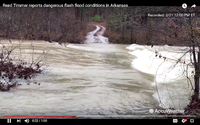
With the icing situation in the Great Plains, let's not forget the flash flood risk. Here an image from a video by my friend, Reed Timmer with AccuWeather . That is a normally dry road. As of 9pm, the magenta is a flash flood warning and the green is a flood warning. Remember: Turn around, don't drown!

Latest Precipitation Amount Forecast

Image
Here the radar as of 5pm. This is rough  forecast of the amount of freezing rain expected. The amount of snow expected. The amount of precipitation (rain and melted ice/snow) : To see the latest advisories and warnings, scroll down.

What a Mess!!

Image
Here is the latest map of National Weather Service storm messages. Here is how to decode this: Dark blue = winter weather advisory for snow or ice Dark green = flood watch Light greens = flood warnings Red = flash flood warnings (an urgent situation Yellow = a tornado watch that expires at 5pm Please use extreme caution traveling in the areas where flooding is occurring or imminent. Remember, turn around, don't drown. 

Latest Ice and Snow Amount Forecast

Image
These forecasts are through sunrise tomorrow (Thursday). While the wind is not expected to be much of a factor, there will be enough ice in north Texas and southern Oklahoma that power failures are possible. Below is the snow accumulation forecast until 6am Thursday. More snow is possible in Nebraska and Iowa after this time. Please prepare accordingly.

More Ice On the Way

Image
Freezing rain and sleet -- some accompanied by lightning and thunder -- have begun in Texas. It is spreading north. Here is AccuWeather's forecast for freezing rain and sleet to Thursday evening. Travel will be difficult due to icy conditions and there may be a few power failures.

Tornado Watch in Louisiana

Image
Posting this because it is only the third watch of 2018. Keep an eye on the weather if you are in the watch area and be prepared to take precautionary measures if a tornado warning is issued.

Wichita: The Calm Between Storms

Image
Another gorgeous Kansas sunset (this is what it actually looked like) this evening. After freezing rain and sleet during the night and gloom all day, the leaden sky broke in time for this sunset. More wintry precipitation is likely starting tomorrow afternoon.

Dangerous Flash Flood Threat the Next 24-Hours

Image
If you are planning to travel, even locally, in the red areas between now and noon tomorrow be extremely cautious when traveling. Remember: Turn around, don't drown. 

To Help You Picture What These Conditions Mean When Used in Road Reports

Image
These same adjectives are used in other states, as well.

This is Amazing - Earthquake Warnings in Mexico

While we cannot warn of an earthquake in the sense of letting people know before the ground begins shaking near the epicenter (origin point) of a quake, if there is a dedicated network of seismographs people away from the center can be warned. They have such a network in Mexico (we do not have one in the United States). Here is what happened during the recent quake after the warnings went out. The story is so well done, I would prefer for you to go to it directly.

Central Plains Update: 9:30pm Monday

Image
Snow accumulation now until 11am Tuesday. Freezing rain accumulation now until 10am Tuesday. Note: I am skeptical of that much freezing rain south of U.S. 400 due to slightly warmer temperatures. Otherwise, this may be reasonable. There will be streaks of higher amounts due to thunderstorms. Update 10:30pm. The forecast band of thicker ice accumulation from near Kingman and Cheney Lake through Alma and northwest Topeka/Shawnee Co. and then to St. Joseph looks like it is fairly well positioned. I expect amounts of 1/4" or more along that band. Update 10:40pm. Classic freezing rain situation with warm (darker) clouds moving northwest during the last three hours. 7:30pm 10:30pm

Flood Risk Update: 5:15pm Monday

Image
Below is the forecast rainfall for the next ten days. My flooding forecast from 11:30 yesterday evening has not changed. Note: The flooding already in progress in northern Illinois and adjacent areas does not count as this is a forecast.

The Reality of Alternative Energy

Image
Below is a graphic showing the worldwide distribution of energy generation systems. After all these years, "green" energy hardly makes a dent: 0.8% is wind and solar. A meteorologist in Denver, via Twitter, became quite unhappy with me last week because I am insufficiently enthusiastic about alternative energy. Actually, I am not at all enthusiastic about wind primarily because it usually fails when needed the most (extreme cold and extreme heat conditions are usually accompanied by light winds). Solar on the other hand, with the advances in battery storage capabilities, draws a thumbs up from me. I believe it has considerable potential. H/T: Bjorn Lomberg.

Flood Risk Update: 11:30pm Sunday

Image
After looking at new data this evening, below is my forecast of where the greatest threat of flooding is from now until the end of the month. I am confident flooding will develop. The flooding Monday and Tuesday will primarily be along the middle Ohio River. Rains that will begin tomorrow will cause the flooding to gradually spread over the entire area by by the end of this week. It will continue until the first of March, if not beyond.