Flash Flood Threat
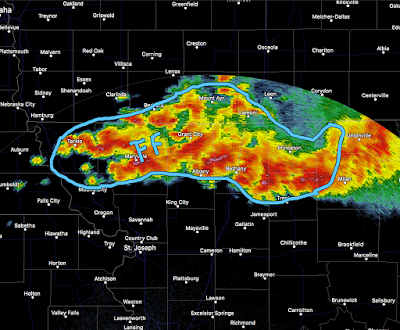
There is a serious flash flood threat developing in northern Missouri and far southern Iowa about halfway between Des Moines and Kansas City.
The radar echoes are from 8:15pm CDT. The area outlined in blue is the area at greatest risk for flash flooding. More than 5 inches have already fallen in parts of the area and an additional 7 to isolated 10 inch total rainfalls are possible. Rainfall in the area has been heavier than normal the last five days.
With darkness falling, please do not try to travel in this area (including I-35). If you encounter water over a road, turn around, don't drown!


Comments
Post a Comment