Posts

Showing posts from June, 2017

The Tragic Story of DDT

Banning DDT was one of the human race's worst moves, ever. Why? Deaths from malaria skyrocketed after the ban. We need to bring it back. Story here .

Central Kansas: First Severe Thunderstorm Warning

Image
Large hail and, perhaps, damaging winds to 60 mph and 1" hail are possible. This will be the last update of the evening. Please monitor local sources of weather information during the night. Highly recommend the AccuWeather App for keeping you informed during the night.

Severe Weather Update: 9:15pm

Image
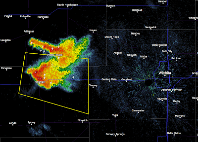
Thunderstorms now rapidly developing in south central Kansas, generally west of Wichita . I suggest that people in the greater Wichita area keep a close eye on the weather between now and 10:30pm. These storms may become severe. Radar is from 9:08pm. Farther west , the storms continue to grow over the High Plains. These may congeal and turn into a derecho overnight.

Damaging Wind Forecast - 8:30pm Thursday

Image
Here is the view from my back yard at 8:20pm CDT. This is of a dying thunderstorm over west Wichita. Radar at 8:24pm shows the dying storm near Wichita while near storms form quickly near Cheney Lake  (not shown) and Pretty Prairie. At the same time, thunderstorms are increasing in intensity and coverage in the High Plains. These are going to congeal over the next 4-5 hours and produce a threat of widespread damaging winds.  I agree that there will be a large area of wind damage potential over south central Kansas...in fact, I might add another 30 miles or so on the north side. Wind gusts could approach 75 mph in the red area and as far north as Hays and Russell. So, charge your phone and computer NOW (but take them off the chargers before any lightning arrives). There is a risk of scattered power failures. ---- UPDATE: 8:44PM. 8:49pm radar. And, at 8:40pm, From met back yard, the eastern (green) radar echo is in the foreground while the developin...

Two Areas of Tornado Risk

Image
The SPC has two areas of tornado risk this afternoon and evening. One is between Wichita and Kansas City and the second is between Yankton and Omaha. I suggest that people in those areas monitor local media when thunderstorms approach.

Lightning Deaths

Image
This is a very useful graphic from NOAA showing lightning deaths in the United States the last ten years. The vast majority of lightning deaths are men (blue). Unfortunately, the third of the year occurred yesterday, a construction worker in Florida.

Last Weather Update of the Night

Image
I outlined the 8 inch and 10 inch areas as of 9:45pm. As you can see, it continues to rain in the region with rainfall rates still greater than 2"/hr. at times. However, I believe the worst of the rain will end by around midnight in the areas I have outlined. Roads are closed and rivers (see below) will rise rapidly during the night. This is the last weather update for the evening. 

Update on Missouri Flash Flood

Image
Here is the radar at 9:29pm. I have plotted the 3" amount line and 5" amount line. There are a number of areas of 7" plus within the 5 inch area. US 69 is already flooded. There is the potential for I-35 to flood overnight. A few spots may receive storm totals of ten inches. Remember: Turn around, don't drown.  Because the rivers flow generally from north to south, rivers will rise rapidly later tonight and tomorrow  morning. If you live near a river that tends to flood, you may have to move to higher ground.

Flash Flood Threat

Image
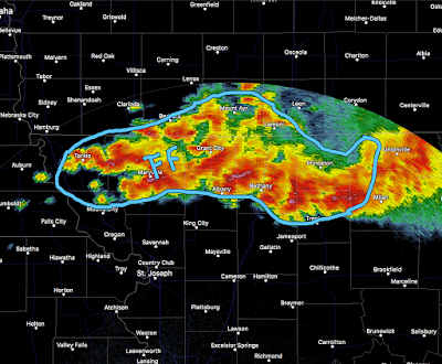
There is a serious flash flood threat developing in northern Missouri and far southern Iowa about halfway between Des Moines and Kansas City. The radar echoes are from 8:15pm CDT. The area outlined in blue is the area at greatest risk for flash flooding. More than 5 inches have already fallen in parts of the area and an additional 7 to isolated 10 inch total rainfalls are possible. Rainfall in the area has been heavier than normal the last five days. With darkness falling, please do not try to travel in this area (including I-35). If you encounter water over a road, turn around, don't drown!

Tornado Watch: Chicago and Rockford

Image
This is the fourth tornado watch of the day. In effect until midnight. Please keep up on the latest information.

Tornado Watch #3

Image
The tornado watch includes Madison and western suburbs of Milwaukee.

Second Tornado Watch Issued

Image
This tornado watch is in effect until 10pm and includes western Wisconsin and far eastern Minnesota including the eastern part of the Twin Cities area.

Large Tornado Watch for the Midwest

Image
This watch extends from Omaha and Tarkio to almost Madison, Wisconsin. At 3:02pm, thunderstorms are rapidly developing in the west and north part of the threatened area. Recommend monitoring local weather information sources.

Midwest Tornado Risk

Image
The area in brown has a significant risk of tornadoes later today. So, if you live in the area from Madison to Omaha and Tarkio, please keep up on local weather warnings.

Looks Like New Hard Cover Copies of "Warnings" are Gone

Image
The "1 to 3 weeks" (at right) means that none of their suppliers has a copy. It is unlikely they will find one. So, if you want to read Warnings, I recommend you save about $10 (over the hard cover version) and get the ebook version . It has more photographs than the hard cover book and you do not need a Kindle or Nook to read it. You can use the free Amazon Kindle Cloud Reader . With the Cloud Reader, the pages will look exactly the same as if you had a Nook or Kindle.

Gorgeous Time Lapse

Take just two minutes and 15 seconds and watch this. It is a supercell (with tornado) forming and then merging with a second storm.

"The Science Police"

On highly charged issues, such as climate change and endangered species, peer review literature and public discourse are aggressively patrolled by self-appointed sheriffs in the scientific community. A must-read article, here . H/T: Judy Curry.

Update on Flooding Risk

Image
Here is the 7-day rainfall amount forecast. I continue to be worried about flooding from northern Missouri into Michigan (where rivers are already running high). In addition, it looks like an active week for severe thunderstorms starting tomorrow. I'll have more on that later in the day.

This Week's Rainfall

Image
Looks like the Midwest is going to see another week of heavy rain.

No New Posting Today

Apologize for the lack of a posting today.

Thanks For the 5-Star Review

Image
Thank you for the latest 5-Star Amazon review from a verified purchaser. It is much appreciated.

Ohio Valley Tornado Threat Today

Image
There is an area with a significant tornado risk today and that is in the southern Ohio Valley. If you live in the area shaded in brown, I recommend you keep an eye on the weather.

Thursday 10:45am: Tornado and Flood Threat From Cindy

Image
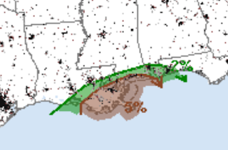
Cindy, itself, is inland and weakening. However, the threat for tornadoes and serious flooding continues. Here is the latest on the tornado threat from Tropical Storm Cindy: The area in brown is the significant threat area for tornadoes until 7am Friday. Heavy rain has fallen throughout the central Gulf Coast region. Below is the actual rainfall for the last seven days. I chose that number to illustrate how saturated the ground is already. More than ten inches have fallen in the purple areas. Here is the forecast for additional  rainfall until 7am Monday.

Major Flood Threat

Image
I continue to be concerned about serious flooding as rainfalls up to eight inches are forecast with Tropical Storm Cindy. Please keep advised as to local forecasts and warnings.

Spectacular Weather Video

This is just terrific. FRACTAL - 4k StormLapse from Chad Cowan on Vimeo .

Flood and Tornado Risk: Gulf Coast

Image
With the weak system in the tropics headed for the Texas-Louisiana area, here are some forecasts I want to bring to your attention. There is a significant risk of weak tornadoes (but all tornadoes are dangerous) along the immediate Gulf coast. There have already been tornado warnings this morning. The more widespread threat is flooding. Here is the rainfall among forecast for the next three days. Flooding is a possibility in the areas with heavier rains. 

Update on "Warnings"

Image
There are a few hardcover copies around still. While Amazon is out of hard cover copies, one of its suppliers says they have at least one. There are two other alternatives: If you wish to obtain a hard cover copy, personally autographed, send $25.00 (including tax and shipping) to: Mike Smith Enterprises, LLC, 4031 N Tara, Wichita, Kansas 67226. Be sure and let us know how you want the autograph to read. The second is to read it on Kindle , Nook or Amazon's free cloud reader. The ebook version has eight extra photos we were not able to get into the hardcover version. Happy Reading!!

This is a Terrible Day to Fly

Image
Wow, it has been a long time since I have seen a list of airports, coast-to-coast, with serious weather problems this long. Here it is as of 9:55am CDT: Boston DFW International Dallas Love Newark JFK Los Angeles LaGuardia Philadelphia Seattle And, this is just the beginning. Strong thunderstorms are forecast to begin after noon Central / 1pm Eastern in the yellow and orange areas. This means that Washington, Baltimore, the Washington, Albany and Richmond airports will get into the act and that Raleigh and Charlotte may, also. Atlanta may have a non-severe thunderstorm.  You might think, "But, I am flying to Minneapolis, which isn't on your list." True. But, with planes going back and forth to hubs the problems quickly spread. So, here is what I suggest: If there is an earlier flight, take it. Earlier is better when thunderstorms threaten. Patience, patience, patience.  Buy snacks and water but no so much you'll get stuffed. With thunderstorm...
I Have a Relative That Says This

Image
Via Twitter.

Sunday Fun: "Picnic" and the Tornado

Image
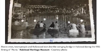
Via The Wichita Eagle A fascinating vignette from a story about the restoration of a Kansas bridge made famous by the movie, Picnic. The Wichita Eagle  explains in the story about the bridge and its fame, While the movie was being filmed in Kansas, Udall was struck by a tornado, killing more than 75 people, injuring more than three-fourths of the town and destroying 192 buildings. After the Udall tornado, the Hollywood film crew turned to Cecil Carrier, a local weather TV forecaster, to help soothe the nerves of Novak.  She wanted to have a personal briefing each day, because she was frightened of tornadoes. Read more here: http://www.kansas.com/news/state/article151876302.html#storylink=cpy Because there was zero warning, the Udall tornado, which killed 77 (out of a population of 500), was an especially terrifying event . I had never heard about Cecil and Kim Novak. Thank you, Beccy Tanner, for your interesting story! BTW: Significant tornadoes are much less...

If You Are Flying East Monday...

Image
...it looks like a mess. This is SPC's forecast of severe thunderstorms from 7am Monday to 7am Tuesday. Yellow (15%) is the significant threshold. The red area is double that. It is forecasting the chance of large hail and damaging thunderstorm winds. If this is a good forecast, the airlines will melt down. So, I suggest the following: See if the airline will let you go tomorrow. Or, go Monday morning when the thunderstorms will be less widespread. If you are flying Monday afternoon or evening, be prepared for major delays. 

A Fascinating Story About What Happens to People Struck By Lightning

It is here .

Heads Up: Kansas, Northern Oklahoma, Western Missouri

Image
A very strong line of thunderstorms is moving across Kansas overturning 18-wheelers, causing small tornadoes and power failures. It looks like it will sweep across Wichita and Topeka in the next few hours and into western Missouri and northern Oklahoma before it is finished. Please monitor local television and radio. Prepare for power failures that may  last more than a few hours. Take care of infirm friends and relatives well before the storms arrive. Put the car in the garage. Bring in lawn furniture and trampolines and other items that might blow about. This will be my only blog update on these storms. Follow me on Twitter:  @usweatherexpert 

And, They Want Us to Send Them More Money So They Can 'Fight' Global Warming

Image
According to the Associated Press, the WHO routinely has spent about $200 million a year on travel expenses—more than what it spends to fight AIDS and hepatitis ($70.5 million), tuberculosis ($59 million), and malaria ($61 million) combined. The story is here . The WMO's (United Nations' World Health Organization) plan for combatting global warming is here and it says, in 2015, the WHO Executive Board endorsed a new work plan on climate change and health. This includes:  Partnerships:  to coordinate with partner agencies within the UN system, and ensure that health is properly represented in the climate change agenda. Awareness raising:  to provide and disseminate information on the threats that climate change presents to human health, and opportunities to promote health while cutting carbon emissions.  Science and evidence:  to coordinate reviews of the scientific evidence on the links between climate change and health, and develop a global research a...

Conflicts of Interest at the EPA? Naaahh!

Image
I rest my case.

Tornado Watch: South Dakota, Wyoming and Nebraska

Image
Tornado watch in effect until 2am MDT/ 3am CDT.

PDS Tornado Watch: Colorado, Nebraska, and Wyoming

Image
This is a big deal. Please make sure your friends and relatives are aware of the situation. Please also make sure children and the infirm can get to shelter on  short notice.  There is a "high" chance of violent, long-track tornadoes as well as 4" diameter (!) hail. The watch includes Ft. Collins, Sterling, Wheatland and other cities in addition to the ones listed. It is vital you monitor the weather situation if you live in the tornado watch area.  PDS = "particularly dangerous situation" tornado watch. It is in effect until 8pm MDT. 

Flood Risk in Montana and Idaho

Image
More than four inches of rain are forecast to fall in the next two days over western Montana and northern Idaho.

Large Area of Tornado Risk Today

Image
The significant (5%, brown) area of tornado risk extends from Monday to the Mississippi River to the northern suburbs of Denver. The 15% area represents a serious risk with the hatching a forecast of violent tornadoes. There is also a risk of large hail throughout the region. I urge people in this region to keep a close eye on the weather later today. There is also a meteorological research project going on in the area. If you see odd-looking vehicles, please be courteous and let them move about.

Sunday Fun: Who Says Detailed Rules and Regulations are Required?

Image

Sunday Fun: Rural America and Weather

Image
From Twitter:

Tornado Risk: Wisconsin & Upper Michigan

Image
We have a tornado risk over northern Wisconsin and Upper Michigan later today. Also, the risk of a damaging wind event, large hail and, perhaps, a tornado has increased tomorrow. This includes the Twin Cities.

Updated Wheat Harvest Forecast

Image
From now until Sunday evening: No thunderstorms or showers in the area where the harvest is taking place. Sunday evening, as a front moves into the High Plains, a couple of thunderstorms could cause some light rainfalls. A few thunderstorms are possible Monday afternoon and evening but amounts will be quite light. Wednesday is the next time that significant rain is forecast in the areas where the harvest will be occurring. Note: These comments apply only to areas where the harvest is projected to be occurring on the days in question. Good luck!!

Wheat Harvest Weather

Image
For the next four and a half days, dry conditions are expected in Kansas and Oklahoma. The green you see is rainfall amounts (now until 7pm Tuesday) of less than 0.1 inches except the darker greens which are right around a tenth. With the warm weather and lower humidity, harvest conditions should be ideal.