Posts

Showing posts from February, 2017

Last Posting of the Night

This is the last posting of the night. Keep in mind there is a significant risk of tornadoes, even after 10pm, so keep up on the weather late tonight.

6:30pm Fat Tuesday Tornado Outbreak Update

Image
First, there is a new tornado watch in effect for western Missouri and southeast Kansas to the east of Kansas City. The watch is in effect until 2am. There have been numerous tornadoes in northern Illinois this afternoon. Serious damage reported in Ottawa, Illinois. I am increasingly concerned about the Ohio Valley region during the night.  This tornado situation could continue past 10pm. Please plan on monitoring the weather as long as you are in a tornado watch.

Fat Tuesday: Third Tornado Watch

Image
This tornado watch is in effect until 10pm CST.

Fat Tuesday Tornadoes: Second Tornado Watch Issued

Image
Thunderstorms have been developing rapidly the last 20 minutes or so and are expected to continue to intensify. This tornado watch includes Chicago and Peoria. This tornado watch is in effect until 10pm.

2:45pm Fat Tuesday: First Tornado Watch Issued

Image
The first tornado watch of the day has been issued. Please note the likelihood of tornadoes is "high" and the probability of strong tornadoes is "moderate." There is also a high risk of large hail. I recommending communicating with your friends and relatives in the region to insure they are aware of the risk. This includes people in the St. Louis-Branson-Springfield, MO areas.

2:30pm Fat Tuesday Tornado Risk Update

Image
Risk of Damaging Tornadoes and Damaging Hail Starting After About 4pm and Lasting Well Into the Nighttime Hours The NWS's tornado risk is unchanged from earlier with the exception of the 10% (yellow) being expanded in Missouri to include Sedalia, Warrensburg and Kirksville.  Please scroll down for preparation suggestions. One of the reasons I am urging you to put your car in the garage isn't just the risk of tornado damage but also the high risk of giant hail. This map has a significant probability threshold of 15% (yellow). The probability of 45% is quite high. The hatching is the area where hailstones larger than 2" in diameter are forecast. So, get those cars in the garage! The first severe thunderstorm warning has been issued (in Missouri). So, it is time to complete the preparations if you are in one of these areas. I recommend taking preliminary tornado and severe storm precautions which are: Make sure you have at least two sources for receiving w

Tornado Risk Raised

Image
According to the National Weather Service, the tornado risk has now moved into what I would call the serious category. Please compare the map below with the one I posted earlier this morning. The original elevated risk, 10% chance of a tornado within 25 mi. of any given point (yellow), hasn't changed much from the earlier forecast. However, the risk has been raised to 15% (red) in the Ohio Valley. This is a fairly big deal if the forecast turns out to be correct. There is the potential for tornadoes to occur well after dark. Please call your friends in this region and make sure they are aware of the risk. So, now I recommend taking preliminary tornado and severe storm precautions which are: Make sure you have at least two sources for receiving warnings. If one includes a NOAA Weather Radio, make sure the batteries are fresh and that it is turned on.  If you need a second source, the AccuWeather smartphone app will provide warnings for your area. But, if you decide you want

Significant Tornado Danger This Afternoon and Tonight

Image
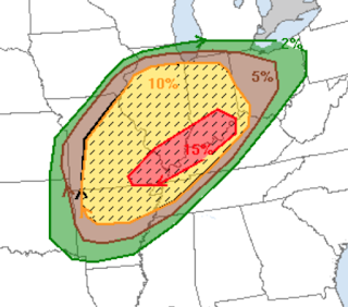
The forecast has worsened since yesterday. On this map the significant threshold for tornadoes is 5% (brown). The ten percent (yellow) is an elevated risk of violent tornadoes (hatched). This includes St. Louis, Little Rock and southwest suburbs of Chicago. If you live in the hatched area, I urge  you to monitor the latest weather information at the first sign of thunderstorms this afternoon and tonight.

The Crisis in Science (Continued)

Yet another report on the reproducibility crisis in science. A very basic tenet of the scientific method is that scientists report their experimental results (often in scientific journals) so that others can reproduce them to insure the results were valid. Report after report (red link) shows that bogus results are a huge, and growing, issue. I salute the journal Nature  for now requiring the data needed to reproduce the results be part of the publication.

ABC News and Wichita: Political Thoughts From the Heartland

ABC Breaking News | Latest News Videos ABC News visited Wichita and asked how people are feeling about the Trump Administration and about how people are viewing the economy. As this is a Wichita-based blog, I thought you'd be interested. Note: Sorry I cannot seem to get the video centered. All the important content is there.

Tornado and Damaging Wind Situation

Image
On this map, 15% (yellow) is the significant threshold for large hail, damaging winds or a tornado. This particular forecast has probabilities up to 30% (red) and an area (hatched) where highly damaging winds (gusts of 75 mph or higher) or a violent tornado could occur. If you are in the hatched area, you may wish to make preliminary  plans in case power should be cut off in your area. In any case, please plan on monitoring the local weather tomorrow.

The Real Dangers Posed by Big Climate

I frequently hear, "Even if the advocates of catastrophic global warming are wrong, what do we have to lose by implementing these changes?" I reply by explaining that turning the world economy upside down, making those living in extreme poverty less well off, and spending $19 trillion (yes, trillion) doing so would be an immoral misallocation of resources. Here is even more evidence from California: If [government] spending is the equivalent of prayer to a leftist, “climate change” is the equivalent of Christian “end-time” cultism. Let me share with you a very recent, and very relevant, example. Over the past week, we here in sunny insane California have faced the prospect of a major calamity as three merciless months of near-nonstop rainfall have led to the possibility of a massive failure at the tallest dam in the U.S., in Oroville, near Sacramento. It’s a big deal; 188,000 people have been evacuated. Concerns about how the aging Oroville Dam would fare in the face of

RIP: Bill Paxton

Learned this morning that Bill Paxton, start of Twister,  has passed away at age 61 due to complications from surgery. May he rest in peace. Details from Variety . 

Sunday Fun: Let Your Ideas Out

Image
Hat Tip: Ali Davis.

Spectacularly Beautiful Drone Images

Image

Tornado Risk in the Midwest

Image
There is a tornado risk, as well as a higher risk of thunderstorms with damaging winds, in the Midwest today. The storms will move very fast. Please monitor local weather information when things appear threatening.

An Interview With a Possible Science Advisor to President Trump

Andy Revkin has a great interview with Dr. Will Happer of Princeton, a candidate to be science advisor to President Trump. I concur with Dr. Happer's views of global warming.

Update on Blizzard and Wildfire Risk

Image
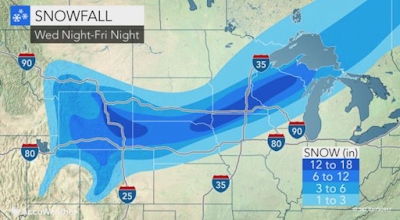
Here is AccuWeather's latest forecast of snowfall amounts. Update on watch and warnings: Orange is a blizzard warning. Pink is a winter storm warning (a slightly lesser condition). Blue is a winter weather advisory (a much lesser condition than a blizzard warning). Hunter green is a winter storm watch (Wisconsin area). Gray is a dense fog advisory. Magenta is a wildfire danger warning. Brown is a high wind warning. Below is the NWS's assessment of wildfire danger later today.

Lots of Watches and Warnings

Image
Lots going on with this NWS map. Orange is a blizzard warning  (the most serious condition) Pink is a winter storm warning. Magenta in the southern Plains is a high fire risk.  Lime green is a blizzard watch. The hunter green in the Upper Midwest is a winter storm watch. Green (Idaho) is a flood warning. The purple in the intermountain region is a winter weather advisory.  Here is a computer model forecast for noon Friday. The low pressure system is on the Missouri-Iowa border. The solid lines are "isobars" = lines of equal barometric pressure. Where they are close together, the winds are high. Green is rain with darker colors corresponding to heavier rains. The orange and magenta are sleet and brief freezing rain. The purples are heavier snow (darker purples are heavier snow).

Lots of Severe Weather to Talk About

Image
Florida The meteorological situation has not developed in the way I originally forecast. There could still be an isolated tornado or a thunderstorm could cause a damaging wind gust today but the threat is not particularly high. Blizzard The forecast has not changed much. The blizzard begins later today with high winds and low visibilities throughout the region where heavy snow is forecast to fall. This is forecast to be the worst storm in six years in the Twin Cities. More details from AccuWeather . Friday Severe Thunderstorm Situation Damaging winds and an isolated tornado possible. Details from AccuWeather .

"A Drought Forever"

As you watch the images of California flooding, keep in mind the global warming crowd told us , “We are in a drought forever,” Patzert said. “I can’t think of any scenario where we would have six wet El Niño years in a row, which would top out all the reservoirs and the ground water supply.”

Update on Blizzard Forecast

Image
Here is the forecast accumulation: High winds and low visibilities will accompany the snow. Full details from AccuWeather .

Florida Tomorrow

Attention Florida readers. There is a chance of tornadoes in the Sunshine State tomorrow and tomorrow evening as a low pressure system in the upper atmosphere moves across the Peninsula. I'll have an update tomorrow morning.

Essential Reading

I try not to label articles "essential" very often but this article from The Spectator  certainly is. While it makes a number of valuable points about global warming, I would like to focus on this statement: Two decades ago, air bags were made mandatory for all autos sold in the U.S. Over the years, the National Highway Safety Administration began to recognize research that found that air-bags could either deploy when inappropriate — even taking lives, especially of children — or not deploy in accident situations. But it refuses to reconsider its mandate or even to allow the removal of faulty airbags firing at 200 miles per hour when a scientific  Journal of Trauma  study reported by NIH found that airbags provided little protection beyond ordinary seatbelts. Independent research of mine, while I was working on Warnings , revealed exactly the same thing. Please consider: Airbags add about $1,000 to the cost of a new car.  While driver's side airbags have some value

Yes, A Blizzard

Image

Weather Science Does It Again

Image
According to preliminary reports, the tornado in San Antonio last night was preceded by a tornado warning. From the San Antonio Express News :  Griffin said soon after she got the notification for a tornado warning last night she heard strong winds that sounded "just like a train" coming down her street. and, later in the same article: According to San Antonio Fire Department spokesman Woody Woodward, only five San Antonio residents had minor injuries in the storms, even though more than 100 homes were damaged.  "Which is amazing," Woodward said. Again, while preliminary, it is not so much amazing as it is the warning system. Congratulations to the NWS and everyone involved!

Sunday Fun: Chemistry as Practiced in D.C.

Image
Yes, she really said that (in 2008).

Slight Tornado Risk Today

Image
The area in brown has a significant risk of a tornado or two later today. This includes Wichita Falls, Lawton and far west part of DFW Metroplex. Stay tuned to the weather in your area if thunderstorms approach.

Sunday Fun: Wichita is One of America's Most Artistic Cities

While this doesn't surprise residents, it may surprise those living in the rest of the nation. As Expedia, in an article about America's most artistic cities says, In true hipster fashion, if you want the insider scoop on the best art towns in America while they’re still under the radar, there’s no better place to be than Wichita. This is one of the greatest places in the country to live and visit. Come and see us!

Another Foot of Rain in California

Image
Yes, that is another 12+" forecast for the watershed above the Oroville Dam (which appears to be fixed) and another nearly 10 inches forecast in the coastal mountains just south of San Francisco. This is going to touch off another round of serious flooding. As to my comment (below) about the possibility of severe weather tomorrow in the Great Plains, here is the risk map. On this map, 15% (yellow) is the significant threshold. Here, the main threats are wind gusts of 60 mph with thunderstorms and some storms with 1" in diameter.

Saturday Weather RoundUp

Image
The storm in California was, unfortunately, as bad as I thought. There is excellent coverage at the Los Angeles Times .  There is a risk of flash flooding in the Southwest Desert region today and tonight. There is, yet another, flooding threat to central and northern California. There is some risk of severe thunderstorms in the Great Plains on Sunday. More on that later.

This May Be the Most Intense Storm in Southern California Since 1983

Image
Here is a regional radar map from the NWS: The line of thunderstorms is now approaching San Diego. Damaging winds and flash flooding are likely.

My Apology

I am dealing with some family medical issues and will not have a blog update today. Hope to have one tomorrow. I hope you will understand.

Major Flood Threat Throughout California

Image
More highly dangerous flooding likely for California.  Before getting into the serious topic of the floods that will occur as a result of latest storm to affect California, it need to point out another catastrophically wrong forecast from climate 'science.' The 100-year drought ended 97 years early. That terrible forecast enabled politicians and other decision makers to defer maintenance on dams and other projects to bring water to a thirsty state. Now, to the issue of more torrential rain coming to California. Yes, the NWS is forecasting 13.4" of rain over the next seven days in the Oroville River/Dam's watershed. It is also forecasting as much as 10.9 inches of rain near Santa Barbara with heavy rains extending east into the mountains above the Los Angeles basin. Given the wet soil and already high levels of water in reservoirs and rivers, flooding will likely  occur in areas that rarely flood. If you live in one of those areas, I urge you to plan

Another Day With a Tornado Risk

Image
The 2017 tornado season has been much more active than last year's to this point. We had six tornadoes in Texas yesterday with four in the Houston metro area. We have a risk of tornadoes in the Southeast today. I have included the scale. The threshold I consider significant (enough to make me want to monitor the weather when thunderstorms approach) is 5% (brown). The highest probabilities are very rarely used values of 45% and 60%. The definition of the probability is the chance of one or more tornadoes within 25 miles of any given point. When you see black hatching it means the tornadoes are forecast by the NWS Storm Predication Center to be "significant" -- meaning EF-2 or stronger in intensity.

But, We Are Supposed to "Trust Science"

Image
Or, as Slate  writes further into the article, A decade later, comprehensive smoking bans have proliferated globally. And now that the evidence has had time to accumulate, it’s also become clear that the extravagant promises made by anti-smoking groups—that implementing bans would bring about extraordinary improvements in cardiac health—never materialized.  Yet, we are supposed to completely overturn the world economy and spend $19 Trillion (yes, trillion) dollars on less-reliable energy sources because of scientific studies of the same quality as the one in Helena.

Valentine's Day Suggestion

If you haven't made a plan for this evening for you and your sweetheart, may I suggest taking him or her to see La La Land?  It is the perfect Valentine's Day movie.

New Tornado Watch

Image

Gulf Coast Tornado Risk

Image
The brown and yellow areas have a significant risk through this evening. There is currently a tornado warning in the Houston area. Please keep up on the weather in this region.

Sometimes Old Advice is Worth Repeating

Older men should not shovel heavy snow. Details here . I finally hired a shoveling service three years ago and haven't missed a minute of it.

Heads Up: Western Gulf Coast Region

Image
The National Weather Service is quite concerned about tornadoes as well as severe thunderstorms in the region tomorrow. Please keep in mind that 15% (yellow) is the significant threshold on this particular map. If you live in the region, please monitor the weather all day tomorrow.

AccuWeather Still Up and Running!

Image
UPDATE: 3:10PM CST: Pleased to report the NWS has fixed the outage and data is now flowing normally.  Original Posting From the Washington Post: This what people seeking radar data from the National Weather Service are currently receiving.  Sorry to report the National Weather Service (NWS) is experiencing a nationwide data interruption that includes radar and other important data. At this point, the loss of data is approaching 2.5 hours. Fortunately, AccuWeather has a number of redundant sources for data and we are able to service our clients and the public with no interruption in radar or any other data. This outage affects the NWS itself. Even with a blizzard in New England and a storm in Texas, their national weather radar map is blank. Had this occurred last week at this time, users would not have been able to receive radar information as the New Orleans tornado was occurring. In the meantime, AccuWeather is serving all of its users as we normally do.

The End of California's 'Permanent' Drought

Image
A nice posting at WattsUpWithThat.  So far, the spillway has held. I wonder if all of the "permanent drought" nonsense caused by the global warming crowd provided a rationalization for delaying necessary water projects. The last I heard, the spillway has held. The Sacramento Bee  has had good coverage. UPDATE 7:38am. Sure enough. Warnings of the dam's failure were not acted upon . Heavy rains expected the next seven days.

Dam Failure Crisis in California

Image
The auxiliary spillway on the Oroville Dam is likely to fail within the hour according to news reports. The town of Oroville, immediately downstream, is being evacuated on an emergency basis. Traffic is gridlocked just outside of town. Evacuations are being conducted downstream in the river's flood plain. Here is a link to The Sacramento Bee's   emergency coverage . UPDATE 6:53PM PST: California Department of Water Resources has released this photo of the damaged spillway. UPDATE 6:59PM PST: If you need an inundation map, it is here . Here is the NWS's flash flood and flood warnings: This is the last update on this situation. Please check the purple link above for updates.