Posts

Showing posts from January, 2017

A Modern Coal-Fired Plant Would Solve the Problem

Image
The New York Times   apparently misses the irony in its story about air pollution in Mongolia. An estimated 7,000 people, many of them wearing air masks and gas masks underneath thick winter hats, braved temperatures that fell below minus 20 degrees Celsius (minus 4 Fahrenheit). Standing in the city's central Sukhbataar Square, they held black balloons and protest signs. One banner read: "Wake up and smell the smog." Ulaanbaatar is one of the world's coldest capitals, and more than half of the city's 1.3 million residents rely on burning raw coal, plastic, rubber tires and other materials to stay warm and cook meals in their homes. In impoverished neighborhoods that ring the city, known as ger districts, many herders and others live in traditional round tents without heating, leaving them to burn polluting fuels. Want to lift people out of dire poverty and  lessen pollution? In some parts of the world, traditional fuels are the answer. 

"I'm Glad I'm Young Enough"...

...said the 99-year old African-American women, who is the subject of Hidden Figures,  to see her work and the work of other black women to be recognized. Here name is Katherine Johnson, she went to high school at the age of 10, and the Washington Post  has a great story here .

Happy Birthday, Kansas

Image
Today is "Kansas Day," the anniversary of Kansas' admission to the Union. This state is such a wonderful place to live and has been very good to me and to my family. A photo I look in western Kansas in 2014. And, the Gyp Hills from 2014.

Saturday Fun: Popcorn Popping at Ultra Slow Motion

Image

50 Years Ago at this Time...

Image
NASA photo of Apollo One astronauts arriving for test.  The Apollo One crew was entering their capsule for a critical test on America's way to the moon. Later, fire swept through the capsule and the astronauts: Grissom, White and Chaffee, we all killed. I'll never forget ABC News breaking in with the bulletin while I was watching television with my family. If I recall correctly, that was a Friday, also. Here are two outstanding articles about this under-remembered event: Ars Technica and my friend, Eric Berger . Washington Post  is here .

A Great Summary of Last Weekend's Tornado Outbreak

Image
I spent most of last weekend tweeting about tornadoes and tornado warnings. Here is a summary of what actually occurred.

Things Have Really Calmed Down

Image
Other than lake effect snow, things have really calmed down across the nation. Here is the five day precipitation forecast across the United States.

Mary Tyler Moore, Pt. 2

Image
I wasn't planning a second posting about the death of Mary Tyler Moore. But, t have been some incredibly insensitive comments on Facebook about Mary's death. Today's women who wish to work or wish to make business a career seem to have no idea how much they owe her. ABC News, rightly in my opinion, broke into its programming with a four-minute (unusual for its length) bulletin about her passing. Please, young people: watch and learn.

Word to the Wise

Image

RIP, Mary Tyler Moore

Image
Just last week, I watched the "Chuckles Bites the Dust," one of the most loved episodes of the Mary Tyler Moore Show.  Kathleen and I loved spending Saturday nights in to watch Mary and Bob. May she rest in peace.

Why a Bathtub is Good Shelter in a Tornado

Image
If you don't have a basement, meteorologists emphatically recommend putting as many wall between you and an approaching tornado. That is why a small closet in the middle of a home or a bathtub are good places to take shelter. We learned of this rather exceptional experience in this past weekend's tornadoes: This occurred in east Texas and the story was via the Capital Weather Gang . It is also a good idea to drag a mattress or blankets over the tub with you in it.

Monday Fun: Congratulations Director Mike Pompeo

Image
Wichita's Mike Pomepo was confirmed as CIA director this evening. I'm sure I join everyone in wishing him success in his new position. He is a very smart person and an excellent choice for the job. If any of you have seen the movie  Zero Dark Thirty,  you'll remember that the late James Gandolfini played the CIA director in the movie. Here they are side by side. Which is which?

Hello, Everyone

Image
With all of the storm warning work over the weekend, I began the week a bit behind. So, it will take me just a little while to catch up. I do want to make sure that you know about the two areas of storms in the U.S. tomorrow. The first is in the Northeast.  These AccuWeather graphics pretty much tell the story. Farther west, another winter storm . If you live in these areas, please plan accordingly.

That's All For Tonight

After three very long days, I am calling it a night. There are no tornado warnings in effect anywhere in the U.S. and the storms -- which have taken at least 20 lives this weekend -- have calmed down a bit. Thanks for following the coverage.

6pm EDT Update

Image
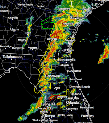
Here is a summary of the situation at this point. After a bit of a lull, several tornado warnings (red polygons) have been issued in Florida and southeast Georgia in the last ten minutes. This is still a potent weather situation. You may wish to make sure your friends and relatives are aware. We do know there have been tornado fatalities in Georgia, but we do not have any more information as to numbers or exact locations at this point.

Particularly Dangerous Situation Tornado Watch #3

Image
This for central Florida. According to SPC, there is a high risk of a violent tornado. This includes Orlando, Tampa and Daytona Beach. Please monitor for warnings as the line of thunderstorms moves onshore and strengthens.

Particularly Dangerous Situation Tornado Watch #2

Image
This watch is in effect until 10pm EST. Please make preliminary precautions (see below, scroll down) to take cover.

Large, Violent Tornado in Southern Georgia

Image
Here is what the tornado looked like as it moved through the Albany area. Radar shows the location of the tornado's circulation at 3:45pm. If you have friends, relatives or coworkers in the tornado warning areas, please urge them to take cover. This is the type of situation that gives meteorologists nightmares.

High Tornado Risk Extended South

Image
If you live in the brown area or into the areas with the higher numerical values, you need to be prepared for the possibility of a tornado warning being issued. Advice on how to prepare is below, please scroll down. The high tornado risk now extends south to Tampa. The hatched area is where violent tornadoes are forecast. The tornadoes may continue well after dark.

The New Round of Tornado Warnings Begins

Image
Here is the radar at 2pm Eastern. There is likely a tornado on the ground just southeast of Tyndall, AFB. Take cover, NOW!  There is a weaker rotation north of Cedar Grove. Both are moving northeast. This represents the round of tornado warnings we were confident would begin this afternoon. More will be issued. Please keep up with me on Twitter @usweatherexpert . 

1:58pm EST Tornado Forecast Update

Image
Here is my forecast of the highest risk between now and 3pm EST. The storms are moving as fast as 60 mph -- so you won't have much time to take shelter. So, if I were in the purple area, ahead of the storms, I'd be gathering up the kids/infirm relatives and would be monitoring the weather closely. For Atlanta, there is a second line of storms well to the southwest but could reach the area later this afternoon.

PARTICULARLY DANGEROUS SITUATION TORNADO WATCH

Image
Here we go again. Particularly Dangerous Situation Tornado Watches are rare and they command respect. If you live in the watch area and it is safe to do so (no thunderstorms in the immediate area), prepare now.  Note that this includes Atlanta where the Packers-Falcons game is going to be played. It also includes Jacksonville and Tallahassee. Note there is a "high" risk of violent tornadoes along with thunderstorm winds of more than 75 mph ("65+knots"). Please scroll down for preparatory suggestions for this dangerous situation. Stay tuned for update.

Coverage Update

Image
I will update the blog on the vicious tornadoes forecast for the Southeast periodically. I urge you to also follow me on Twitter   @usweatherexpert . While I am proud of our blog coverage, if you live in the threatened area (see below), you also need at least two sources for receiving warnings for your local area. I am expecting the NWS will be issuing additional tornado watches and I will post those when they are issued. And, if you have ever wondered how meteorologists save lives by forecasting and warning of tornadoes, we have a book for you !

A Terribly Dangerous Day Ahead

Image
There is a  high risk  of tornadoes the rest of today and this evening in the Southeast. I wish I had been able to stay up longer last night as at least 11 fatalities occurred when the thunderstorms reintensified (see below). I wanted to save some time for today because it is going to be a terrible day meteorologically. You'll recall that brown (5%) is the significant threshold for tornadoes. Thirty percent is an extremely high number. The hatched area is where violent  tornadoes are forecast. My advice if you live in these areas? Make sure your family and friends can get to shelter on short notice. If there is someone who is infirm and needs extra time, you might want to pick them up before the storms approach. In addition, make sure you have at least two ways to get warnings in addition to your local television: NOAA WeatherRadio  Sign up for the excellent  WeatherCall .  The AccuWeather app will let you know if a watch or warning is issued.  Put your car in the garag

Sunday Fun

Image
Artist Unknown

11:50pm Severe Weather Update

Image
The NWS particularly dangerous situation tornado watch continues until 3am. But, note there are no storms to the west of the watch and the storms in the watch itself have been weakening the last two hours. Here is what I believe is occurring: The low pressure system over the northeast Texas Panhandle (above) and the trough extending to near Houston are behind schedule. The low was supposed to have been over south central Oklahoma by now. The trough is strong enough to trigger showers and thunderstorms over southeast Texas but hasn't made it far enough east to trigger strong/tornadic storms over Louisiana or Mississippi. I believe storms will redevelop in that area after about 2-3am. However, it has been another long day, so this is my last post of the night. I still advice keeping up on the weather if you live in the tornado watch.

Updated Tornado Forecast: 9pm

Image
Here is my forecast as of 9pm valid until 2am Sunday morning. The red polygons are tornado warnings as of 8:47pm. Yellow polygons are severe thunderstorm warnings. I have sketched the area with a risk of tornadoes along with what I believe has the highest risk of violent tornadoes until 2am. Please keep up on the weather in this region!!

Tornado Watch Until 3am

Image
The risk of tornadoes is "high" and the risk of violent tornadoes is "moderate" until 3am. Please see below for preparatory advice. 

Rare PARTICULARLY DANGEROUS SITUATION TORNADO WATCH

Image
Very Dangerous Situation. See forecast for entire region below tornado watch.  Has been issued until 3am for the southern two-thirds of Alabama, the Florida Panhandle and a small part of eastern Mississippi. Very few tornado watches, fewer than one in twenty, are "particularly dangerous situation" watches. Note: Watch extended into Florida at 9:50p CST. Please note the risk of violent tornadoes overnight is "high." The advice I gave earlier should be reinforced: Have two ways (at least) to get the warning: NOAA WeatherRadio  Sign up for the excellent  WeatherCall .  The AccuWeather app will let you know if a watch or warning is issued.  Put your car in the garage and bring in trampolines or anything that can be blown about.  Here is the forecast for tornadoes from now until 7am.  Brown, 5%, is the threshold for tornadoes. Yellow is an elevated risk. Red is, in my opinion, a high risk. The hatched area means violent  tornadoes are possible.  T

6:15pm Update

Image
The yellow is a tornado watch until 9pm and the red are tornado warnings. There are indications that the storms in central Louisiana may begin to strengthen and increase the chance of overnight tornadoes farther east. Stay tuned.

First Tornado WARNING Issued

Image
While there have been lots of tornado warnings today, this is the first tornado warning with the second wave of storms. It is in the Ark-La-Tex area northwest of Shreveport. I do not live-blog storms. I'm posting this just to make you aware that if you live in one of the tornado watches (see below) it is time to begin focusing on the weather at the first sign of a thunderstorm. 

Tornado Watch for the Ark-La-Tex Region

Image
This tornado watch is in effect until 9pm. In addition to the risk of tornadoes, note the forecast for >1" hail is a "high" probability.

Tornado Watch Just Issued

Image
The NWS has issued a tornado watch for parts of Louisiana and Mississippi. It includes New Orleans and Hattiesburg (which was hit by a fatal tornado at 4am this morning). This watch expires at 9pm. Please note there is a "moderate" chance of strong tornadoes.

Very Dangerous Tornado Situation Developing

Image
Please take a good look at the post below if you live in the Southeast. The probability of violent tornadoes has increased for the nighttime hours.  Four people died in Hattiesburg because of a 4am tornado. The same type of situation could develop this evening and overnight. Please allow me to explain what you are viewing. The brown area has a significant chance of a tornado, it is roughly the threshold of the NWS issuing a tornado watch. The yellow is a an enhanced risk of a tornado. The red is a high (in my opinion) risk of a tornado. The hatched area is where violent  tornadoes could occur.  There is also the risk of giant hail, similar to the risk this morning. The hatched area may have hail >2" in diameter. So what do you do? Make sure you have at least two ways of getting a warning. NOAA WeatherRadio  Sign up for the excellent WeatherCall .  The AccuWeather app will let you know if a watch or warning is issued.  You have time to do all of these. Also

Updated Tornado and Giant Hail Outlook

Image
Please take note of these forecasts if you live in the Southeast. Tornado Forecast The brown area has a significant risk of tornadoes between now and sunrise Sunday. There is an enhanced risk in the 10% (yellow) areas. The hatched area, which has been extended into South Carolina, has a risk of violent tornadoes. Giant Hail Forecast On this map, the significant threshold for >1" hail is 15% (yellow). There is a very high probability of 45% in parts of Mississippi, Arkansas and Louisiana. Where you see the hatching, the hail is forecast to be larger than 2" in diameter. 

9am Saturday: Elevated Tornado Risk in the Southeast

Image
There is a large area with a significant (brown, 5%) tornado risk between now and sunrise Sunday. There is an enhanced risk in the yellow areas with violent tornadoes possible in the hatched area. Currently, there is a tornado watch in effect until 11am for parts of Alabama and Florida. And, a second tornado watch in effect until 3pm EDT.

One More Update: 11:10pm

Image
Tornado Watch just issued until 7am. These are issued by NWS. My forecast is below. If you are in either, please have a way to get warnings during the night. The tornado watch for southwest Louisiana and far southeast Texas (light pink) continues in effect. At 11:05, thunderstorms near Palmetto (northeastern storm) and Welsh, Louisiana (southwestern storm) may develop tornado potential during night. This is the last update of the night.

10:45pm Friday: Tornado Outlook for the Rest of the Night

Image
Here is my forecast for the rest of the night with regard to the tornado risk: Please find two ways to get any tornado warnings during the night. There is also the potential for very large hail and damaging thunderstorm winds. Here is the NWS radar at 10:42pm. No tornado warnings at this time but the storms are intensifying. This is the last update for the night.

That Ice Storm That Was Over Forecasted??

I just learned that more than 5,000 homes are still  without power in northwest Oklahoma and the Oklahoma Panhandle from last weeks ice storm. I also understand there are still homes -- a week later -- without power in southwest Kansas. Consider: We gave the region four days of advance notice so they could prepare for this serious ice storm.

Serious Overnight Tornado Risk

Image
There is already a tornado warning  in effect. Please keep an eye out if you live in these areas. Also, there is a larger risk area later during the night.  The brown, 5%, risk area is the significant tornado risk threshold. The yellow has an elevated risk and the hatched area is where a violent tornado could occur. More tornadoes likely Saturday.