Posts

Showing posts from February, 2016

Severe Weather Potential

Image
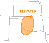
There is also a pretty good chance of large hail later today and this evening in Oklahoma.

Sunday Fun: Oh, NO!

Image
The last thing you want to see when a brand new, freshly painted locomotive comes off the assembly line. http://tracks.lionel.com/the-bigger-they-are-the-harder-they-fall-watch/ And, while we are on the subject: The funny piece is here . (link fixed)

More Winter Weather

Image
Yet another winter storm for the Midwest. AccuWeather has details.

Must Read: Paris Agreement Will Not Put a Dent in Global Warming

Yep. The Paris Agreement will cost trillions but will perhaps avert 0.17°C of warming. Environmentalist Bjorn Lomborg has details .

If You Don't Have a Basement....

Image
....there is a simple tornado safety rule: Put as many walls between you and the tornado as possible. From Twitter:

Weather Science's Eternal Issue

Image
From Twitter, the comment meteorologists make among ourselves over and over. And, I agree completely with Blaine and Kate. The issue is that weather science has done almost nothing to market the value we produce to society. One would think that during a major tornado outbreak, where people are reported to be killed, it would be obvious. But, it is not. I propose solutions here:

Tornado Outbreak Continues

Image
So far, three deaths have been reported this afternoon. Via Twitter: Here is map of the tornado watches (yellow), tornado warnings  (red), winter storm warning (pink) and blizzard warning (orange).  The greens are flood warnings and browns are high wind advisories and warnings. 

Second Day of Tornadoes Likely

Image
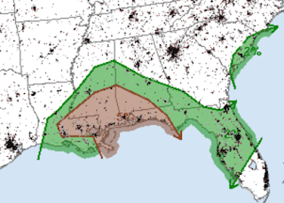
After tornadoes killed three yesterday, there is a chance of major tornadoes in the hatched area which includes Norfolk and Raleigh with significant threat area (brown) into central Florida as far south as Ft. Myers. Please keep an eye on the weather in this region.

6:20pm Tornado Risk Update

Image
The tornado threat continues over a broad area of the South. Below is the updated tornado forecast at 7pm. The area outlined in purple has, in my opinion, a dangerous risk of tornadoes between now and 11pm. As of 6:14pm, a number of tornado warnings are in effect (red polygons). Now that it is dark across the area, the danger goes up. Please keep an eye on the weather if you are in these areas. 

5pm Tornado Update

Image
Jeff Piotrowski intercepted this tornado coming off northwest Lake Ponchartrain at 4:46pm. Here are the two tornado watches in effect until 11pm: There is a watch to the southwest of New Orleans that expires in one hour. Scroll down for the tornado probability map through 6am CST Wednesday.

"Particularly Dangerous Situation" Tornado Watch!

Image
These are rare -- only one of these was issued in all of 2015. A particularly dangerous situation (PDS) tornado watch is issued when there is a "high" likelihood of strong tornadoes. I urge you to prepare your family, friends and relatives for the possible of taking shelter if a tornado warning is issued or if the situation appears threatening in your area.

Tornado Outbreak Under Way

Image
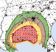
Here is an earlier photo of three tornadoes over Lake Pontchartrain via Facebook. Several tornadoes -- at least one with damage -- have already occurred. Here is the latest tornado probability outlook. Please keep in mind that brown (5%) is the significant threshold. If you live in that area or the 10% area (yellow) you should monitor the weather. If you live in the hatched 15%, hatched area (where violent tornadoes are forecast)  I strongly recommend keep the children nearby and making provisions for the infirm now , before a tornado warning is issued. A reminder: We no longer live-blog storms but I will update the situation at least once more this evening.

Update on Tornado Threat

Image
Here is the updated "tornado only" probabilities from the Storm Prediction Center. Five percent (brown) is the significant threshold (which includes Atlanta). Fifteen percent is quite high. The hatched area is where violent tornadoes are forecast to occur. A number of school districts have called off school. If you live in the hatched area, I recommend: Making sure you have a shelter area ready to go. It should include a flashlight with fresh batteries. A radio or television that will work even if the power fails. If you don't have a TV/radio of that nature, a smartphone will work. Make sure you wear shoes into the shelter.  If you are hit, know where to turn off the electricity and gas. Keep the kids nearby.  If you have an infirm friend or relative, make provisions now.  Make sure you have adequate gas in the car. Pumps in your area may not be working if the power goes out.  I no longer "live blog" storms but I will update at least two more time

More Great Reviews of "Warnings"

Image
With a major tornado threat for tomorrow and tomorrow night, this popped up on Facebook a few moments ago: So very pleased that Scott enjoyed Warnings  and recommends the book. For those outside of the South, James Spann is a legendary television meteorologist who has saved countless lives with his superb severe storm coverage. This is how James' review begins: Most of you know I work a pretty long day… up before 5 a.m… not home until around midnight. My passion for weather keeps me going and energized. Unfortunately the long hours prevents me from reading many books, but I was able to finish “Warnings: The True Story of How Science Tamed the Weather” by my friend Mike Smith this month. For those that love weather, this is one of those books that is hard to put down. Not only is it a history of the severe weather warning system in the United States, it also weaves in the personal story of Mike’s long career. James' entire review is here . So, if you are interes

Dangerous Tornado Threat Tuesday

Image
If you live in the 15% or higher area, it would be good to keep on eye on the weather Tuesday and Tuesday night.  In the hatched area, there is the potential for violent tornadoes -- including after dark in the eastern half of the area. So, this a situation where people should keep a close eye on reliable local weather information sources.

Tough Week East of the Mississippi

Image
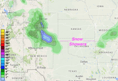
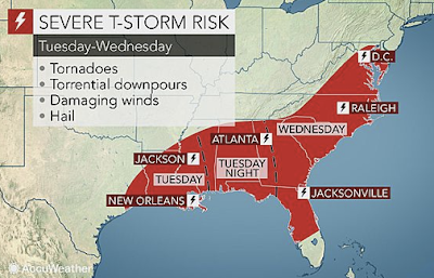
If you are traveling, it may be a messy period as a significant storm is now beginning to develop. So, let's run it down chronologically. Tonight and Tuesday As the storm gets organized, snow showers will occur in the Plains and Colorado Rockies. Very heavy snow will occur near the New Mexico-Colorado border. A winter storm warning is in effect for that area. Midweek The storm gets much better organized Tuesday night and by Wednesday and Thursday heavy snow and ice will be a problem in the indicated regions. AccuWeather has more. Tornado and Severe Thunderstorm Risk Keep up on the weather if you live in the outlined areas. 

Increasing Tornado/Severe Thunderstorm Threat

Image
Please keep an eye on the weather mid-week as the chances of tornadoes and severe thunderstorms increase to potentially dangerous levels. I'll be updating with additional forecasts as the event approaches.

Sunday Fun: Investigative Journalism Today

Image
Without comment...

Rainfall This Week

Image
Here is the new Global Forecast Model forecast of rainfall amount for the next seven days.

Change in Weather Pattern

Image
Several changes are going to occur to the weather pattern next week that I thought you would want to know about in chronological order: Needed Rains Although the geographic extent of the rain is still somewhat in question, badly-needed rains in the central and southern Plains will occur early next week. Snow The next winter storm is going to set up farther west than recent storms. AccuWeather has more. Severe thunderstorm/Tornado Potential So, you may wish to factor all of this into your plans for next week.

Badly Needed Rain Next Week

Image
From yesterday's extremely high fire danger one could tell that the central and southern Plains needed rain. Finally, some is in the picture next week!

Need a Book for Spring Break?

Image
Here is the perfect book for spring break. The book is a smash with both readers and critics alike as the reviews demonstrate. It is an uplifting story of heroic ventures by the pioneers of the storm warning system that saves thousands of lives each year.

A Very Rare Occurrence

Image
My brother was driving along I-70 near Hays, Kansas, a little while ago and sent me this photo of his car thermometer. Mark said the thermometer topped at 91°F. Based on weather stations in the western half of Kansas, this is the warmest February day, ever, since records began being kept in the late 1880's. But, here is the just amazing part. There is snow on the ground. Speaking as a person how has been interested in weather for 59 years, I've never seen this before!

But the Science Has Been Settled For Years

Image
From Instapundit:

Extreme Fire Danger!!

Image
I have never  seen an outlook this severe over this large an area. Please use extreme caution with anything that could cause a fire today and this evening. 

Extreme Fire Danger

Image
The dry weather in most of the central and southern Plains since January 1 is catching up with us as very high west wind gusts and very low humidities are going to combine to extreme wildfire danger Thursday with elevated danger today. Today's Fire Danger Thursday's Fire Danger I can't overemphasize how serious this danger is. Please be extremely careful with anything that could potentially start a fire.

Where Tornado Deaths Occur

Image
The number of tornado deaths, by state, is highest in the South

Our Hearty Congratulations to the Airline Industry Worldwide

Image
With the exception of airlines being shot down (which is considered a criminal act), there were zero  airline deaths worldwide  in 2015. The Wall Street Journal  has details. A significant contribution to this accomplishment is improved weather data and weather forecasts for aviation purposes. Air travel may be cramped and in many ways miserable but it is exceedingly safe. For that, the airline industry deserves our thanks.

Bring Back DDT! Fast!

Between 600,000 dead children in Africa each year and the new Zika virus, it is time to declare war on mosquitoes. Now. Today. Before another state follows Hawaii's lead and has to declare a state of emergency. For those too young, DDT was an incredibly effective tool against mosquitoes that was thought to harm birds. We now know it does not. Environmentalists hate to admit they are wrong to the extent that children are expendable. While some contend, perhaps correctly, the mass fumigation was a problem, the judicious use of DDT under the present circumstances should be immediately considered.

Good Rich, Bad Rich

Image
When did it become a crime to succeed  in this country?! n   Bobby Axelrod, character in Showtime’s Billions I hope you don’t mind me writing about economics today because, after some comments made during last week's debates, I believe there is a vital point to be made in this Presidential election year. This same topic is the reason for so much superheated debate about global warming. We’ve heard a lot recently about the evils of “the rich” or the “1%.” That is not an accurate description of the problem. I believe there is an important distinction to be made depending on how the person becomes “rich.” Here’s an example: the late Walt Disney (and, to a lesser extent, his brother Roy) built the Walt Disney Company with a vision of providing wholesome family entertainment. After nearly going bankrupt several times, they succeeded. Given the inflation since Walt passed away in 1966, in today’s dollars he would be a billionaire many times over. And, that is just fine

Tornado Risk Today

Image
The brown area has a risk of tornadoes from now through this evening. A tornado watch is currently out for part of the area. If you live in the brown area, please keep up on the weather as thunderstorms approach or the skies darken. Note: As previously announced, this blog no longer does live blogging of storms.

International Association of Venue Managers

For those who manage venues, large or small, weather is a serious concern . So, I am pleased to be one of the instructors of this year's severe weather course at the meeting of the International Association of Venue Managers in Dallas on Friday, February 26. Please click the blue link for more information.

Rest in Peace, Justice Scalia

I thought the final paragraph of the story about Scalia's life in this morning's Wichita Eagle  was the perfect way to sum up his distinguished career. "We don't sit here to make the law, to decide who ought to win. Scalia said. We decide who wins under the law that the people have adopted. And, very often, if you're a good judge, you don't really like the  result you are reaching." Rest in peace, Justice Scalia.   

Valentine's Fun: "Nothin' Says Love Like Cows..."

Image
...said my Valentine a few minutes ago. My delightfully crazy friend, Marion County Kansas farmer Derek Klingenberg, brings everyone a Valentine's message.

Tornado Season Rapidly Approaching!

Image
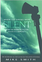
As the 2016 tornado season approaches, may I modestly recommend my book, When the Sirens Were Silent, which is the story of what went wrong with the warning system during the Joplin tornado. As you know, Joplin (161 deaths) is the only tornado to cause triple-digit tornado fatalities since the warning system was created. The book also includes complete tornado safety rules for businesses, for schools and for home. Sirens  is probably the best bargain around with a price of $2.99; but it is available now in Kindle only as the paper books sold out very quickly. The Barnes & Noble Nook version is here . The Amazon Kindle (plus the free cloud reader, you don't need a Kindle to read this version) is here . It is a quick read that will help you and your family take the warning system seriously if a tornado warning is issued this spring. 

2015 Tornado Map

Image
National Weather Service Here is a map of the paths of the tornadoes of 2015. Red numerals highlight states with above normal numbers of tornadoes.

Eastern Storm the First of the Week

Image

Mild Weather Next Week

Image
Depending on your point of view, ore mild weather is expected across the U.S. next week with the exception of Florida. Dry weather is forecast in California and the Plains. There are indications that California will get into a wetter pattern in about two weeks. Note: Apologize for the light blogging. Kathleen and I have been ill this week.

Weather as an Essential Business Tool

Image
I simply don't understand this: Florida Today Just a couple of months after the sinking of the El Faro during Hurricane Joaquin in the Bahamas, Royal Caribbean's Anthem of the Sea  had an encounter with extreme winds and seas damaging the ship, causing extreme discomfort for the passengers and crew, and sending the ship into port prematurely. The cruise line, in a statement sent to USA TODAY, suggested the "extreme wind and sea conditions" that hit as the ship sailed south from the New York area to Port Canaveral, Fla., were unexpected, noting that the wind speeds were higher than what was forecast. While I do not follow marine forecasts closely, I noticed the "hurricane force wind warning" was even on Facebook! Any ship that sails into a forecast of hurricane force winds can't say the winds were "unexpected." USA Today   "The storm was well forecast by many different weather models from every agency. This was not a surprise