Posts

Showing posts from November, 2015

Winter Wheat Boost

Image
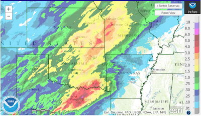
Here is the last week's rainfall up to this morning. Of course, additional precipitation occurred in the Midwest. The message from this map is that the 2016 winter wheat crop will get a major boost from these rains. Amounts over the heart of the winter wheat belt were 1.5 to 3.5 inches generally.

The Value of Meteorology

Image
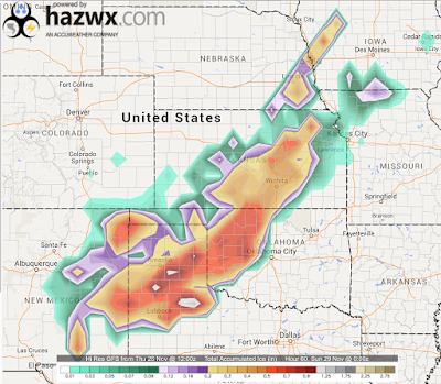
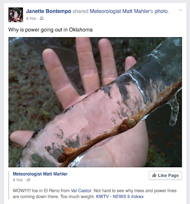
Ice storms are, to me, the most difficult type of weather to forecast. Give me a tornado, hurricane or even snow situation any time. Of course, accurate forecasts are essential because ice storms can cause terrible misery, financial loss and occasionally, injury or death. Part of the difficulty is that ice storms require a specific, and uncommon, structure of the air above the ground. And, the worst ice can be in an area small enough that it is not sampled by weather balloons or instrumented aircraft. So, improving our forecasting tools is essential. Nearly 400,000 people in Oklahoma lost power at one point or another Friday into Saturday evening due to massive amounts of ice. Some are still without power. How can can electric utilities know to prepare for these storms? In 2007, Sidney Sperry (Oklahoma Electric Coops) and meteorologist Steve Piltz (NWS Tulsa) created an index that used wind, forecast ice thickness and temperature to assess the likelihood and severity of...

Cyber Monday Meteorology

Image
The best book about weather is on sale this cyber Monday. Three copies sold at Amazon overnight and they were down to 8 as I am writing this.

Monday, 7:45am: Update on Winter Storm

Image
Ice storms move out, snow moves in. Here is the latest from AccuWeather .

Update on Thanksgiving Return Travel

Image
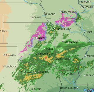
Radar at 9:30am CST. Purple = freezing rain areas. Here is the latest AccuWeather forecast snow starting today and increasing tonight through Tuesday. It is snowing in Denver now. The pink and purple, especially the latter, have ice storm conditions with trees down and icy conditions in places. This includes I-70 between Topeka and Salina. Below is the area where flooding is occurring in the different shades of green. Please do not enter floodwaters.

Global Warming: Can't Resist Commenting on This

New York Times  this morning on global warming: When the Earth’s slow cyclic tilting and wobbling along its eccentric orbital path once again leads to a major cooling period some 50,000 years from now, enough of our heat-trapping carbon emissions will still remain in the atmosphere to warm the planet just enough to weaken that chill. In other words, our impacts on global climate are so profound that we will have canceled the next ice age. They think this is a bad thing? Considering the next ice age would wipe out tens of millions of people through starvation, 'canceling the next ice age' is a great thing!! P.S. I believe the claim is questionable science.

Sunday Fun: Terrific Article About Being a Female Television Meteorologist

Amy Sweeney is a great meteorologist. She has written an insightful blog posting about what it is like to be a female meteorologist that I highly recommend.

Thanksgiving Return Travel: Another Storm!!

Image
To start your day , here is the forecast radar for 5am CST Sunday. Purple is freezing rain. Blue is snow. Darker shades equal respectively heavier precipitation. Greens and yellows are traditional radar colors. A low pressure system in the upper atmosphere will begin to move ENE out of the Rockies Sunday and Monday bringing the following weather: One More Round of Ice With This Low This will fall from now through Sunday evening. The chances of  additional power problems is low. Heavy Snow Calendar Day Sunday accumulations. Calendar Day Monday accumulations: So, the snow may cause travel difficulties in the northern Plains and into the Upper Midwest. Finally, here is an overview of the flood situation: Remember: Yellow: Near flood stage. Orange: Minor flooding occurring or will occur shortly. Red: Moderate flooding in progress or will occur shortly. Purple: Major or Record flooding in progress or will occur shortly.  Water in front of you? Turn a...

Wrap Up of Ice Storm Coverage

Image
Here is the AccuWeather Regional Radar at 2:15pm: There is quite a bit of freezing drizzle along I-35 from Lebo to Emporia to Wichita that radar does not show up. I just finished driving it and it was wet between Emporia and El Dorado with temperatures between 28 and 30 degrees. Just received a report of a power failure in Hutchinson, Kansas, in the band of freezing rain north and west of Wichita. From NewsOK : Here is the headline about the ice storm in Oklahoma. 54,000 "outages" = about 170,000 people affected. AccuWeather has video coverage from El Reno, OK here . There isn't much more to "forecast" so this is the end of the original ice storm coverage. I'll update regarding the early week snow storm shortly. ADDITION FROM OKLAHOMA VIA TWITTER:

Ice Storm/Power Outage Update

Image
Here is the latest AccuWeather Regional Radar. Purple is freezing rain (freezing drizzle is falling in some of the areas that show up blank). The blue (usually snow) in western Oklahoma is sleet. In Kansas, the power loss situation is very mild: Westar Energy The map is the number of clusters  of outages in each reporting area. However, total number of people affected is only about 500 (easy for me to say, I have power and am warm) and the situation is improving. However, it is a completely different situation in Oklahoma. Much of Oklahoma City and central and western Oklahoma are without power. It is so serious, I can't get to Oklahoma Gas & Electric Co.'s site to get an updated map to post. If you were considering returning to Oklahoma today, you may want to keep that in mind. There is also severe flooding in southeast Oklahoma and southwest Arkansas. Purple is the ice storm warning. Freezing rain is now occurring in West Texas.

Terrific Christmas Gift

Image
Five-star reader rating, outstanding critical reviews. The  book for people who have an interest in weather . It is a compelling story  of people, not a "science book." If you like this blog, support it by purchasing a terrific gift for friend or family member -- or, wrap it up and put it under the tree for yourself!

5pm Friday: Multi-State Flood Update; Next Winter Storm

Image
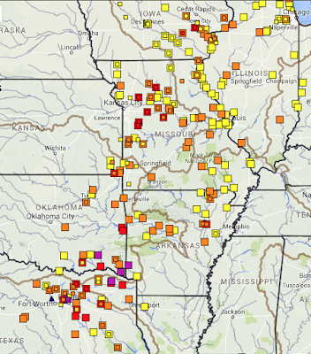
The squares represent locations along rivers that area: Yellow: Near flood stage. Orange: Minor flooding now or expected in the near term. Red: Moderate flooding now or in the near term. Purple: Major or Record flooding now or in the near term.  Here is the forecast for additional precipitation from now until 6pm Tuesday. Note: The bullseye in the northern Plains is a moderate snow storm (scroll down) that will develop.  An additional six inches is forecast in southwest Arkansas! Preliminary Look at Next Winter Storm AccuWeather  has more details.

Forecast Radar for 6am Saturday

Image
Via Twitter from Hammond, Oklahoma: To give you an idea about travel conditions when you get up in the morning: Purples are freezing rain. It is a new area of ice that is forecast to be moving from southwest to northeast. The forecast precipitation amounts from now until 6am look like this. There is a small area of 4"+ in far southeast Oklahoma where flooding is already forecast. We have reports of as many as four people killed in flooding in North Texas today. Think about it: Is trying to cross a flooded area worth your life and your families? Turn around, don't drown. 

Storm Coverage Update

As you can see from the coverage below, I have spent quite a bit of time on storm coverage the last three days. However, I have some AccuWeather work I must do so the next round of updates will not occur on the blog until mid- to late afternoon. The forecasts below look solid. 

10:30am, Ice Storm Update

Image
Here is the AccuWeather Regional Radar as of 10:15am. The gaps in Kansas and Oklahoma are freezing drizzle which does not show up well on radar. Purple is freezing rain and sleet. Blue is light snow. Remainder of colors are those of classic radar. AccuWeather's model shows, below, the amount of freezing rain the next six hours. I urge you to take the weather conditions into your travel plans. And, in Oklahoma, if you are in one of the area of heavy freezing rain (scroll down) plan for the likelihood of power failures.

9:40am Storm Update

Image
Here is the amount of precipitation that has fallen up to 6am (it takes are few hours to collect and process the data). Six plus inches of rain have fallen near Dallas with considerable flooding already in progress. Here is the forecast precipitation from 6am today through Sunday night. Note, that is an an additional 8" on the Arkansas-Texas border. Flooding will worsen over this region through the weekend. Note that in the cold air, considerable sleet and freezing rain has yet to fall.

Oklahoma: Potential Widespread Power Outages

Image
This is index is very reliable in forecasting ice storm-related power failures. Where you see red, purple or black, power failures range from quite possible to almost certain (respectively). The power failures may last more than 24 hours. Please prepare accordingly. There may be scattered power outages in the orange area. Roads will be very icy in the yellow area with, at most, isolated shorter term power outages.

5pm Ice Storm Update: Kansas City

Image
The latest data says that western and northern parts of the KC Metro area could get some freezing rain...with bad roads possible early tomorrow morning.

Ice Storm Update, 3:40pm Thursday

Image
Update on the serious ice storm in the Central Plains: There is a report the power is out in northwest Wichita. It is unclear if this was directly caused by the ice storm. Regardless, this is the first of many areas that will be having power problems tonight. If you live in the area I have outlined, you may wish to fill your car with fuel and get some extra cash at the ATM before the ice arrives . I apologize for the coarseness of this particular model but if you smooth it out a bit in your mind, it gives a very good idea of the consequences of this storm. Green: Bad driving, with the worst conditions on secondary roads.  Yellow: Bad driving conditions on all roads, impassible side roads. A few power outages. Red: Scattered power outages. I believe the red area should extend up to about Wichita.  Dark red to white: Widespread power outages possible.  Please make sure friends and family in the affection regions are aware.  Here is the forecast radar (gr...

Major Flood Update

Image
Flood Situation: Here is a rainfall amount graphic created by the National Weather Service in Norman, OK: click to enlarge Yes, that is more than ten inches in south central Oklahoma!!  There is a serious flooding risk as the holiday weekend advances from the Ozarks to north central Texas. It is a good idea to stay off secondary roads. If you live in this region and your home or area flooded last May, it is a good idea to prepare for flooding again. If you are traveling on Amtrak's Heartland Flier  you may want to double check as that route may be subject to flooding.

Please Be Thankful For Meteorologists

Image
One of my meteorologist friends posted on Facebook: Meteorologists work 24/7/365! I've been working with our superb team of AccuWeather meteorologists in both Wichita and State College today due to the ice storm and the serious problems (power failures and impassible highways) it will cause. We work with highway departments, hospitals, electric utilities, railroads and many other critical organizations to insure their response to the storm is the best it can possibly be. Would I, and we, prefer a quiet Thanksgiving period? Of course! But, our job is to make sure everyone is informed, as safe as possible, and the inconvenience lessened. So, if you know a meteorologist, thank them for all they do.

Rough Idea of Freezing Rain Accumulations

Image
Here is the current precipitation type AccuWeather Regional Radar as of 11am: Freezing drizzle is occurring in the High Plains of Kansas and the Oklahoma Panhandle but radar does not show it well. The purples are various types of freezing rain (mixed with sleet in a few locations). The models have trouble (won't go into the reasons) dealing with freezing rain. That stated, here is a rough  idea of the amount of freezing rain to expect. Click to enlarge If you happen to be in a "hole" between accumulations, don't believe it. Unfocus your eyes and look at these forecasts (i.e.., smooth them in your mind) and it will be more accurate than a specific point forecast.

Serious Ice Storm!

Image
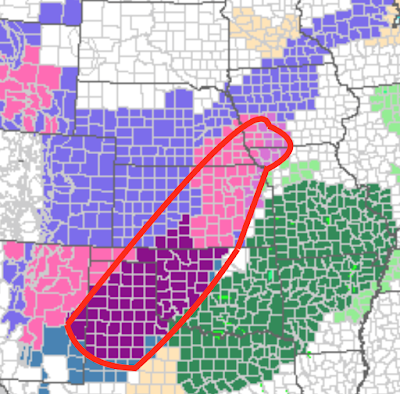
There is a serious ice storm developing in the Central United States.  Power failures and impassible roads will likely result. The area outlined in red is at risk of dangerous to impassible roads. And, from Wichita southwest through the purple area there is a risk of power failures. Icing conditions will begin later today and last into Saturday morning.  The green areas are flood risk areas. The blue to the northwest of the ice storm is for snow or light mixed changing to light snow. The pink areas west of the ice storm warning area is for heavy snow.

Happy Thanksgiving!!

Wishing you the most wonderful Thanksgiving to you and your family!!

4:10pm Wednesday: Updated Storm Warnings

Image
Orange is a blizzard warning along I-80 in Wyoming and Utah. Purple is an ice storm warning in the Texas Panhandle. Pink is a winter storm warning. The greens are flood watches. Here is the probability of a 0.1 inches of freezing rain (glaze ice) or more Thanksgiving Day through Saturday. This has the potential to make highways dangerous and, perhaps, cause power interruptions. I'll provide additional updates on the ice storm threat. Finally, here is the latest 5-day precipitation amount forecast. Please keep all of this information in mind as you plan your travel this weekend. 

10:30am Wednesday Thanksgiving Weather Update

Image
The forecast hasn't changed very much from what I published below. The risk of flooding is considerable. Here is the five-day precipitation amount forecast: Courtesy of Dr. Ryan Maue, here is the forecast which shows scattered showery rain at 5pm this afternoon. At 9am Thanksgiving morning, the rain is much more widespread and freezing rain starts to mix in from Sioux City to Kearney. At 5pm Thanksgiving Day, snow is falling from the Michigan UP to south central Nebraska. Snow is also falling from south central Wyoming to southeast Colorado. Freezing rain is occurring from near Omaha to western Kansas in scattered locations. Thunderstorms with heavy rain over southern Kansas and Oklahoma. Black Friday:  Because you wouldn't get me out there without a court order, I have no idea what time would be best, so I have guessed at 4am CST. Freezing rain is occurring in scattered locations from south central Iowa to eastern New Mexico with widespread, heavy rain fro...