Posts

Showing posts from October, 2015

Tornado Watch Until 7pm

Image
There have been several tornadoes already today. Please keep an eye out. I will not be live-blogging the storms.

Don't Turn Around, Get Stuck in a Tree!!

Image
If you drive into a flooded area, you may find yourself 20 feet up a tree. These incidents are completely preventable. Not only do you put yourself in danger, you put first responders in danger. Turn Around, Don't Drown!!

Happy Halloween!!

Image
Most of the 1.3 billion pounds of pumpkins produced in the U.S. end up in the trash,  says  the  Energy Department ’s website, becoming part of the “more than 254 million tons of municipal solid waste (MSW) produced in the United States every year.” Municipal solid waste decomposes into methane, “a harmful greenhouse gas that plays a part in climate change, with more than 20 times the warming effect of carbon dioxide,” Energy says. Full details here . 

An Interesting Article About Storm Warning Understandability

It does no good to issue a storm warning if no one understands it. Some thoughts on improving warning communication, here .

"This Child Does Not Need a Solar Panel"

While environmentalist Bjorn Lomborg and I don't agree on a lot of things, his commentary in the Wall Street Journal  is exactly on the money: In a world in which malnourishment continues to claim at least 1.4 million children’s lives each year, 1.2 billion people live in extreme poverty, and 2.6 billion lack clean drinking water and sanitation, this growing emphasis on climate aid is immoral. Not surprisingly, in an online U.N.  survey  of more than eight million people from around the globe, respondents from the world’s poorest countries rank “action taken on climate change” dead last out of 16 categories when asked “What matters most to you?” Top priorities are “a good education,” “better health care, “better job opportunities,” “an honest and responsive government,” and “affordable, nutritious food.” According to a recent  paper  by Neha Raykar and Ramanan Laxminarayan of the Public Health Foundation of India, just $570 million a year—or 0.57% of the ...

Really, Really Cool Video

Image
Why does a curve ball curve? Take a look!

No Scientific Reason to Believe in the Global Warming Consensus

Image
And in this short article I have certainly not been able—any more than the IPCC in its lengthy reports—to present a convincing case, based on logic and observations, of why anyone should believe the consensus statements. Couldn't have said it better myself. The full article is here .

Glad to Hear About the Makeover for the Gateway Arch

Details, here .

Climate Scare's "Useful Idiots"

A valuable editorial .

They Love "Warnings" in Canada

Image
They love it in Canada! If you haven't read Warnings , you are missing a great read about storms and the heroic people who risked their reputations to tame them.

Wichita in One Sentence

Liz [Koch] continued. "He could have moved many times. [He] could have moved Koch Industries anywhere in the world you wanted to. But this is a great place for raising children and running a business with values." I am not a native but Kathleen and I chose to start WeatherData here, raise our family here, and AccuWeather Enterprise Solutions has prospered here. Looking for a place to start a family or a business? Check Wichita out!

More Global Warming Propaganda

Image
Please realize all of this is designed to influence public opinion leading up to the Paris climate talks. It will all be forgotten the day after the meetings end. Let's assume for a minute that we all had to move to Antarctica. Did you know the entire population of the world could be comfortably  housed in the states of New Mexico, Texas, Oklahoma, Arkansas and Louisiana? There is plenty  of room in the world.

Update on the South Central Flooding

Image
Here is the current AccuWeather Regional Radar. Here is the rain that has fallen up to 7 o'clock this morning. And, this is the forecast rainfall from 7am this morning to 7am Wednesday. Here is a summary of forecast river stages. Reds = moderate flooding. Purple = severe flooding. Yellow is near flood stage and orange is minor flooding.

Sunday Fun: Good Morning!!

Image
Kathleen looked out our window yesterday afternoon and saw this fellow. Thought it would be a nice way to start a new week. And, a special Happy Birthday  to my brother, Phil!

End of a Long Week

Image
Record hurricane, serious flooding, etc., etc., at least this week has come to an end with a spectacular sunset over Wichita.

Updated Rainfall Forecast and Impacts For Texas and Louisiana

Image
First, here is the rainfall that has fallen with this storm up to 2pm CDT. The NWS is forecasting an additional foot  of rain to fall in the vicinity of Houston and the Orange Triangle with heavy rains east into Louisiana and more than seven inches likely. The torrential rains (upper map) south of Dallas, near Corsicana, will generally flow south southeast toward the Gulf (arrows). This additional rain will fall on top of the rising rivers, rapidly and significantly worsening the seriousness of the flooding. Here is just one example on the Trinity River: click to enlarge The river, after a dry autumn to date, hardly had any water in it. But, in a period of 72 hours, it is going to rise more than 40 feet (!!) to a major flood.  So, I'd like to reiterate our flood safety recommendations: Plenty of extra cash. A full tank of fuel for your vehicle. Freshly refilled prescriptions. Valuables gathered together so they can be quickly put into the trunk so...

Tornado Watch for Texas

Image
The rotational remains of Hurricane Patricia are helping to induce a situation where thunderstorms can rotate sufficiently to produce weak to moderate intensity tornadoes. I will not  be live-blogging these storms. This watch does include Houston and Galveston.

"How Wet...Is..It?"

Image
Johnny Carson and Ed McMahon used to have a bit about the weather where Johnny would say something about a weather extreme and Ed and the audience would ask, "How Hot/Cold/Wet Is It?" You can see one of them at the link. Somehow, I was reminded of "How Wet Is It?" when I saw this sign: It isn't every day you see a rain gauge attached to a booster's sign at a football game!

Arrrgh!!

Image
I tuned in FS1 to watch my K-State Wildcats take on Texas and Kris Budden, the sideline reporter, tells us that "Mother Nature is unpredictable" and that they didn't know it was going to be raining!! All you have to do is scroll down and you will see the flooding rains in Texas were extremely well forecast. AccuWeather, the National Weather Service and just about everyone else forecast it as well. I have no problems with sideline reporters and, earlier this week, wrote a post defending CBS's Allie LaForce against unfair criticism. But, repeating silly clichés about meteorologists is not news reporting. AccuWeather has video of the Austin flooding.

First Assessments on Patricia's Damage

Wow. It looks like the warnings worked. According to CNN : MEXICO CITY — Early reports in the aftermath of Hurricane Patricia — one of the biggest storms to ever make landfall — were cautiously optimistic: No deaths were reported and no signs of major damage were seen along Mexico's Pacific seaboard. Mario Anguiano, governor of the state of Colima, which includes the coastal city of Manzanillo, toured the impacted area just before midnight Friday – nearly six hours after Patricia's landfall – and saw minor damage to buildings and roads but said there were no reported deaths or major damage to infrastructure, such as downed bridges. "The saving of lives has been exceptional," he said in an interview with Milenio Television. Let's home the final reports are as wonderful.

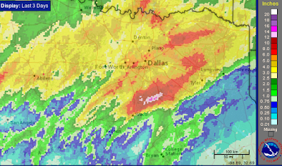
Extreme Rains in Texas

Image
Yes, that is more than 20" in two days south of Dallas. But, the rain is hardly over. The remains of Hurricane Patricia will cause more rain in south Texas.

Does AccuWeather Minutecast™ Work? You Bet!

Image
When the announcers mentioned that rain was headed toward Kaufman Stadium, I set Minutecast for Kaufman where the Royals and Toronto are playing for the ALCS. At 9:27, it said the rain would begin in 33 minutes. Sure enough. The rain began at 10pm. Nothing in meteorology in meteorology is perfect but Minutecast does an amazing job!

10pm Update on Patricia

Image
Earlier today, a weather satellite took this image of the eye of Hurricane Patricia. It illustrates what meteorologists call "the stadium effect." In other words, if you were in a boat, it would look like you were standing in the middle of a major league football field. Here is the 10pm position of Patricia. The storm still has 135 mph winds. At 7am Saturday, the storm will be of tropical storm strength. It is expected to be a tropical depression tomorrow evening. The red on the coast is the continuing hurricane warning because of the winds on the backside of the hurricane.

8:45pm Update on Hurricane Patricia

A weather station in Mexico, near Cuixmala, recorded a sustained winds of 185 mph with a gust to 211 mph before the power failed. That will cause catastrophic damage. If you are on Twitter, click here for a video showing the storm surge reaching the city of Manzanillo. As you can see, it looks like a tsunami as it moves inland.

Special Texas Flood Update

Image
Here is the storm total rainfall through 7pm: The deeper purple colors are more than 14 inches. The Corsicana airport has received more than 13.5", so these radar-based estimates are correct. Severe flooding is reported. Below is the NWS radar from 7:45pm. It was knocked out of service at that time, likely due to lightning. The green outlined counties are under flash flood warnings. The flood situation in Texas will worsen through the weekend.

4:15pm Texas & Louisiana Flood Update

Image
Here is the rainfall that has fallen over the last three days up to 3 o'clock this afternoon. There is already one small area of 10" south of Dallas. Considerable flooding is occurring in that area. Here is the forecast additional rainfall for the next three days. Per the NWS's rainfall forecast above, another 6" is likely south of Dallas. The remains of Hurricane Patricia will cause a second area of extreme rainfall with about 15" near Houston. This is a major flood situation and people in or near these areas should be prepared for flooding..please note that Louisiana is now at risk. Here are some flood preparation recommendations: Plenty of extra cash. A full tank of fuel for your vehicle. Freshly refilled prescriptions. Valuables gathered together so they can be quickly put into the trunk so you can leave quickly if rising waters force you to do so.  A place to go:  A relative's home on high ground, a motel, a public shelter, etc. If you...

4pm Update on Hurricane Patricia

Image
Here is the 3:30pm satellite image of Patricia. The hurricane is an hour or two from the eye's landfall in or just west of Manzanillo. I expect the hurricane's damage to be devastating in and around that city and just inland.   The 4pm advisory from the National Hurricane Center says the pressure has risen to 903 mb (for those interested) with sustained winds of 190 mph. That is still an unbelievable value.  However, even though the storm has "weakened" it is still a category 5 hurricane. You may recall the devastating storm surge associated with Katrina. Even though it was 'only' a Cat. 3 at landfall, the storm surge, which built up while it was a Cat 5 at sea, devastated the southwest Mississippi coast. It is likely, but not certain, that will be the case here, especially around the bay at Manzanillo. UPDATE: 4:32PM. The Manzanillo beach camera just failed.

For the Sake of Decency, Could We Have a Moratorium on the Patricia = Global Warming Stories...

Image
...until at least the storm has made landfall and the injured are attended to? Above is one of more than a half-dozen stories tying Patricia to global warming. It is more likely tied to the El Nino, but that is not important now! Some of us are working as hard as we can to warn the unfortunate people in the path of this monster. People are going to die in this storm but we want the death toll to be as small as it possibly can. Opportunistically taking the focus off the warnings for global warming stories is in terribly bad taste in my opinion.  So, please, give global warming a rest until at least Monday. Thank you. 

Update on Texas Rainfall

Image
Here is the storm total rainfall up to 10 o'clock this morning. More than six inches have fallen in several areas. Here is the forecast for additional rainfall for the next three days. I'll have a complete update late this afternoon.

Strongest Winds Ever Recorded By the National Hurricane Center

Image
The U.S. NHC is designated a regional hurricane center by the United Nations. Therefore, it measures, and offers advice to, other nations' meteorological services with regard to hurricane warnings. A  hurricane hunter aircraft measured Patricia (below) and found 200 mph -- the strongest winds ever measured by NHC -- in the storm which will hit the west Mexico coast this afternoon. Here is a map of the hurricane warning area. I placed an arrow pointing to Puerto Vallarta to orient you. This storm will increase the flood threat to Texas over the weekend and the first of the week. I also liked the Hurricane Center's parting paragraph: The Air Force and NOAA scientists who fly into hurricanes put their lives in danger for us and sometimes we forget that. Yes, thank you US Air Force. I'll update on the Texas rain threat this morning.

Texas Flood Threat Increases

Image
Here is a map of the amount of rain that has already fallen over the past three days. Additional rain over the next 72-hours ending 7pm Monday evening: As previously mentioned, the threat of flooding is high. Part of the reason is the remains of Hurricane Patricia, now a Category 4 hurricane headed for Mexico's west coast, are going to affect Texas. You may recall the fatal flooding in Texas in May. If you live near one of the streams that flooded then, you are at risk of flooding again. Please do not wait until the rivers and streams are rising; prepare now. Here are some flood safety recommendations: Plenty of extra cash. A full tank of fuel for your vehicle. Freshly refilled prescriptions. Valuables gathered together so they can be quickly put into the trunk so you can leave quickly if rising waters force you to do so.  A place to go:  A relative's home on high ground, a motel, a public shelter, etc. If you go to a hotel, have a reservation. You may wi...

Rainfall for 24 Hours Ending at 7am This Morning

Image
Yes, that is more than six inches in west Texas.

The Rains Have Begun

Image
Here is the AccuWeather Regional Radar from 7:15pm CDT: And, the latest 5-day rainfall forecast: Yes, that is a maximum of 11 inches. Flooding is likely. Please see below for preparation recommendations.

7-Day Rainfall Forecast

Image
This is the seven-day rainfall forecast for the south central United States. Two areas are forecast by the NWS to have more than ten inches of rain. Needless to say, this could result in serious flooding. You may recall the fatal flooding in Texas in May. If you live near one of the streams that flooded then, you are at risk of flooding again. Here are some flood safety recommendations: Plenty of extra cash. A full tank of fuel for your vehicle. Freshly refilled prescriptions. Valuables gathered together so they can be quickly put into the trunk so you can leave quickly if rising waters force you to do so.  A place to go:  A relative's home on high ground, a motel, a public shelter, etc. If you go to a hotel, have a reservation. You may wish to consider an "extended stay" type of hotel. Be prepared to put valuable items you cannot take with you on top of tables, on the second floor, or in the attic to hopefully protect them from floodwaters.  If you evacu...

Serious Flood Threat For Parts of Texas

Image
This is the forecast rainfall for Texas for the next three days. Southern Oklahoma is at threaten, as well. Looks like next week may see additional rains, some heavy, in the southern half of the Plains. I have more details on the blog this evening.

Major Rain Event for Central and South Central United States

Image
Here is the latest AccuWeather Regional Radar: Large hail has already been reported in New Mexico this morning. Above is the forecast rainfall for the next seven days. That 7.5 inch maximum is over the DFW Metroplex. The rains will come in one event that will start tonight and continue into the weekend with a second round the middle of next week. Stay tuned for updates.